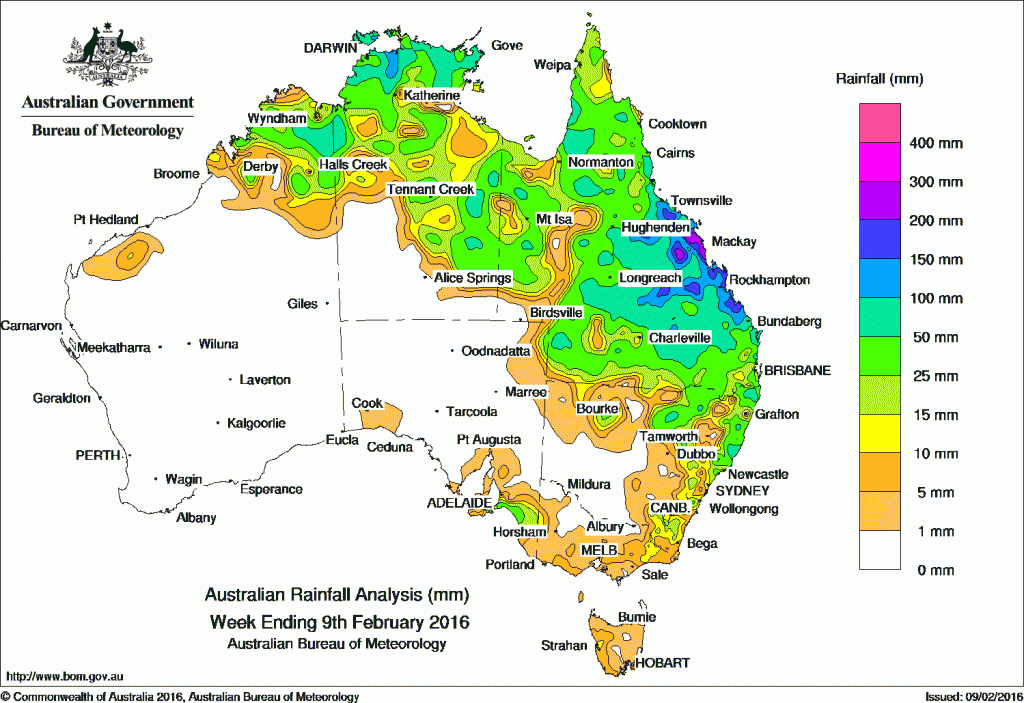
Widespread rain was recorded across large areas of northern and eastern cattle producing country including the Kimberley, large parts of the Northern Territory, Queensland, and eastern and northern New South Wales in the past week.
The remnants of ex-tropical cyclone Stan started the week over the agricultural districts of South Australia. The weakening system generated isolated thunderstorms with moderate falls recorded in areas of southeast South Australia.
From the start to mid-week, an active monsoon trough located across northern Australia brought areas of cloud with embedded thunderstorms to the Kimberley, northern parts of the Northern Territory and the Gulf Country.
A moist, unstable airmass extended over Queensland and northeastern New South Wales, and a deepening low pressure centre along an inland trough produced moderate falls across eastern Australia. Heavier falls were recorded in parts of the central and Wide Bay coasts of Queensland.
At the end of the week, a low pressure system developed near the central Queensland coast and slowly tracked north, generating areas of heavy rainfall about the central coast, and Herbert and Lower Burdekin in Queensland. Moderate, widespread rainfall was also recorded across the Central Highlands and Coalfields districts, extending into parts of the southern interior of Queensland.
Rainfall totals between 100 mm and 200 mm were recorded in the northwest Top End, and in the north tropical coast, Central Highlands and Coalfields, central coast and Wide Bay and Burnett districts in Queensland. Falls in excess of 200 mm were recorded in the coastal strip between Bowen and St Lawrence, and the northeast Coalfields in Queensland, including the highest weekly total of 321 mm at Carmila Beach Road on the central coast of Queensland.
Rainfall totals between 50 mm and 100 mm were recorded in parts of the Kimberley, across the Top End and in the east of the Northern Territory, pockets of western and northern Queensland, and a large area extending from Townsville to Winton and across to Noosa. Similar totals were also recorded in parts of northern and eastern New South Wales.
Rainfall totals between 10 mm and 50 mm were recorded in most of the remaining parts of the Kimberley, the northern half and in the east of the Northern Territory, most of Queensland except the far southwest, northern and eastern pockets of New South Wales. Similar totals were recorded in eastern Victoria and southeastern South Australia.
Most of Western Australia, apart from the Kimberley, all of South Australia away from the southeast, the southern parts of the Northern Territory, western and central New South Wales, most of Victoria, and most of Tasmania recorded little or no rainfall this week.
New South Wales and Australian Capital Territory
236 mm Careys Peak (Barrington Tops)
160 mm Mooral Creek (The Den)
126 mm Port Macquarie Airport AWS
Victoria
36 mm Mount Baw Baw
26 mm Bullumwaal
22 mm Haines Junction (Mount Sabine)
Queensland
321 mm Carmila Beach Road
319 mm Mount Jukes
313 mm Mt Jukes
Western Australia
116 mm El Questro
96 mm Ellenbrae
95 mm Camballin
South Australia
59 mm Goolwa Council Depot
46 mm Meningie
44 mm Victor Harbor (Encounter Bay), Goolwa Barrage
Tasmania
18 mm Mount Read
16 mm Lake Margaret Power Station
11 mm Queenstown (South Queenstown)
Northern Territory
147 mm Gunn Point
123 mm Point Stuart
115 mm Darwin River Dam
More weekly rainfall totals:
- NSW/ACT totals click here
- Vic totals click here
- Qld totals click here
- WA totals click here
- SA totals click here
- Tas totals click here
- NT totals click here
Source: BOM


HAVE YOUR SAY