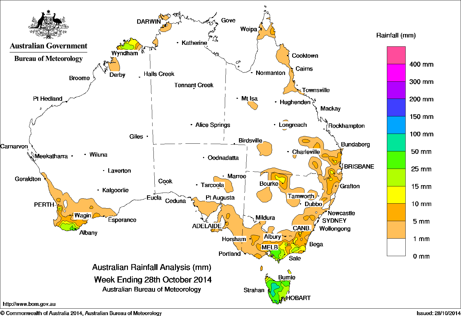
 Rainfall for the past week was recorded in the far north and southwest of Western Australia, southeast South Australia, Victoria, Tasmania, parts of eastern Queensland, and across northern and eastern New South Wales.
At the start of the week, a low pressure system was located over southwest Western Australia with an associated surface trough extending into the Kimberley region in Western Australia which produced moderate rainfall in the South West Land Division. A surface trough over western New South Wales associated with another low pressure system centred over western Victoria triggered isolated thunderstorms through inland and eastern New South Wales.
A weak cold front crossed Tasmania during the middle of the week, bringing light to moderate rainfall to most of Tasmania. A lingering surface trough over Bass Strait and a broad trough of low pressure across southern and western New South Wales resulted in moderate totals through northern Tasmania and in parts of southern Victoria, and light rainfall through much of Victoria and parts of southeast South Australia. A deepening area of low pressure along the northwest coast of Western Australia brought isolated falls to parts of the Kimberley
At the end of the week, a cold front crossed Victoria and Tasmania with an associated surface trough extending northward and connecting with the monsoon trough in northern Australia. Thunderstorms were triggered across parts of eastern Australia, resulting in moderate rainfall totals to western Tasmania and eastern Victoria with some light rainfall also recorded in southeastern Queensland.
Rainfall totals over 50 mm were reported in western and northeastern Tasmania. The highest weekly total was 62 mm at Mount Read in Tasmania.
Rainfall totals between 25 mm and 50 mm were recorded through much of northern and western Tasmania, in a small area of southwest Western Australia and in West Gippsland in Victoria.
Rainfall totals between 15 mm and 25 mm were recorded in the Kimberley and in areas surrounding higher falls in southwest Western Australia, most remaining parts of Tasmania, and through West and East Gippsland in Victoria.
Rainfall totals between 10 mm and 15 mm were recorded surrounding higher falls in southwest and northern Western Australia, eastern Victoria, isolated parts of eastern and western New South Wales, and small areas of southeast Queensland.
The Northern Territory, most of Western Australia except for the southwest and far north, South Australia, inland New South Wales and Queensland, away from the coast, recorded little or no rainfall during the week.
Highest weekly totals by state:
| State | Highest | 2nd Highest | 3rd Highest |
|---|---|---|---|
| WA | Albany (45 mm) (South Coast) |
King River (44 mm) (South Coast) |
Barrett Meadows (40 mm) (South Coast) |
| NT | Channel Island (33 mm) (Darwin-Daly) |
Charles Point (22 mm) (Darwin-Daly) |
Nightcliff Pool (17 mm) (Darwin-Daly) |
| SA | Crafers West (13 mm) (East Central) |
Longwood (12 mm) (Barron Coast) |
Adelaide (Keswick) (12 mm) (East Central) |
| Qld | Queen Mary Falls (55 mm) (East Darling Downs) |
Daintree Village (31 mm) (Barron) |
Jimna Forestry (31 mm) (Moreton) |
| NSW/ACT | Ulladulla (33 mm) (South Coast) |
Daintree Village (31 mm) (Barron North Coast) |
Blackheath (25 mm) (Central Tablelands) |
| Vic | Mount Baw Baw (41 mm) (West Gippsland) |
Ferny Creek (39 mm) (East Central) |
Nilma North (38 mm) (West Gippsland) |
| Tas | Mount Read (62 mm) (West Coast) |
Mount Read (62 mm) (West Coast) |
Pyengana (57 mm) (West Coast) |
Source: BOM
HAVE YOUR SAY