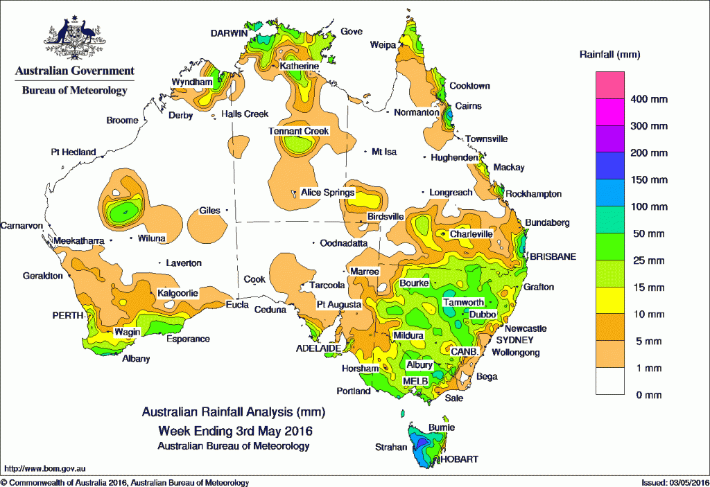
Parts of Central and western New South Wales received some of the best falls recorded in months over the weekend.
At the beginning of the week, a cold front tracked across southwest Western Australia generating widespread, light to moderate rainfall totals in the South West Land Division.
Another cold front moved through the Great Australia Bight, and an associated cloudband with embedded thunderstorms produced light falls in southwest Western Australia and southeastern South Australia. A weak low-level trough lingered over southwest and central New South Wales, before a cold front tracked across the State producing moderate rainfall totals in New South Wales, Victoria and Tasmania.
In the last part of the week, a low pressure system intensified to the northwest of Tasmania on an approaching cold front. The low deepened as it tracked across the State, with a northwest airstream generating heavy rainfall totals in western and northern Tasmania.
Throughout the week, a near stationary high pressure system located in the Tasman Sea directed a moist onshore airstream and persistent shower activity to the east coast of Queensland, with locally heavy falls recorded in the north tropical coast.
Rainfall totals in excess of 100 mm were recorded in western Tasmania, the Victorian Alps and the northeast tropical coast of Queensland, including the highest weekly total of 132 mm at South Johnstone in northern Queensland.
Rainfall totals between 50 mm and 100 mm were recorded in the northern Top End, the south coast of Western Australia, southern and northeastern Victoria, most of western and northern Tasmania, central New South Wales, and small pockets of coastal Queensland.
Rainfall totals between 10 mm and 50 mm were recorded southwest Western Australia, the southern coasts of South Australia, much of Victoria except the east and northwest, Tasmania, central and western New South Wales, along the east coast of Queensland and across much of the Top End of the Northern Territory.
Remaining parts of Western Australia away from the southwest, the Northern Territory except the Top End, most of South Australia, much of Queensland away from the east coast, parts of the southeast coast and far west of New South Wales, and eastern and northwestern Victoria recorded little or no rainfall this week.
Highest rainfall totals in each state and territory
New South Wales and Australian Capital Territory
83 mm Coonamble Airport AWS
80 mm Gilgandra (Chelmsford Ave)
72 mm Dandaloo (Kelvin), Alectown (Cawdor)
Victoria
110 mm Mount Hotham
105 mm Falls Creek (Rocky Valley)
102 mm Haines Junction (Mount Sabine)
Queensland
132 mm South Johnstone Exp Stn
128 mm Innisfail
114 mm Landsborough
Western Australia
60 mm Barrett Meadows
59 mm Denmark
57 mm Grassmere
South Australia
53 mm Mount Schank (Jethia)
44 mm Nangwarry Forestry
40 mm Mount Hope (Fairview), Lake George
Tasmania
131 mm Lake Margaret Power Station
123 mm Quamby Bluff
120 mm Jackeys Marsh
Northern Territory
91 mm Middle Point Rangers
83 mm Middle Point
58 mm Mcminns Lagoon
More weekly rainfall totals:
- NSW/ACT totals click here
- Vic totals click here
- Qld totals click here
- WA totals click here
- SA totals click here
- Tas totals click here
- NT totals click here
Source: BOM


HAVE YOUR SAY