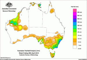
 Rainfall was mainly confined to the south east corner of the country and the far western Kimberley and Pilbara in the past week, which most other areas experiencing a dry week.
Rainfall totals between 50 mm and 100 mm where recorded in the Pilbara and Gascoyne, and in eastern Victoria and southeastern New South Wales. Rainfall totals in excess of 150 mm were recorded in areas of the central coast of New South Wales and parts of east Gippsland in Victoria. The highest weekly total was 324 mm at Maitland Belmore Bridge in the Hunter district in New South Wales, of which, 307.5 mm was recorded in the 24 hours to 9am on the 22nd.
Rainfall totals between 10 mm and 50 mm were recorded across most of eastern New South Wales, eastern and southern Victoria, northeastern and parts of western Tasmania, southeastern and central agricultural South Australia, and large parts of the western Kimberley, Pilbara, Gascoyne and central Western Australia.
Remaining parts of Western Australia, the Northern Territory south of the coastal Top End, western and central Queensland, New South Wales away from the east, northwestern Victoria, and most of South Australia received little or no rainfall this week.
An intense low pressure system located near the boundary of the Hunter and Mid North Coast districts in New South Wales slowly tracked southeast, bringing heavy rainfall to the central coast of New South Wales, with moderate rainfall totals in eastern Victoria. The slow-moving low pressure system weakened off the Hunter coast, and decayed into a broad trough over the Tasman Sea. Moderate falls continued along the southeast coast of New South Wales and in East Gippsland, Victoria through to mid-week.
Light rain fell through central Western Australia as a surface trough along the west coast of Western Australia moved inland. The trough and low pressure system off the east coast of New South Wales generated a cloudband with embedded thunderstorms and brought further light to moderate falls in East Gippsland, southeastern New South Wales, and eastern Tasmania.
In the middle of the week, a cold front tracked across the Southern Ocean, generating light falls in parts of southern South Australia. The cold front associated with a deepening low pressure system located in the Great Australian Bight, tracked across southeastern Australia, bringing moderate rainfall for the Lower Eyre Peninsula, Yorke Peninsula and Mount Lofty Ranges in South Australia, northeastern Tasmania and parts of northeastern Victoria. Light rain continued to fall along parts of coastal South Australia, central Tasmania, southern Victoria and southern New South Wales, with moderate falls recorded across parts of eastern Victoria and southeast New South Wales in a southerly airstream that persisted to the end of the week.
Table of highest weekly totals
| State | Highest | 2nd Highest | 3rd Highest |
|---|---|---|---|
| WA | Newman Aero (58 mm)  (East Gascoyne/Murchison) |
Mount Florance (56 mm)  (Fortescue) |
Coolawanyah (50 mm)  (Fortescue) |
| NT | Yirrkala Tropical Gardens (97 mm)  (Arnhem) |
Gove Airport (87 mm)  (Arnhem) |
Alcan Minesite (66 mm)  (Arnhem) |
| SA | Mount Compass (52 mm)  (East Central) |
Longwood (50 mm)  (East Central) |
Mount Lofty (46 mm)  (East Central) |
| Qld | Coconut Island (15 mm)  (North Peninsula) |
Palmerville (9 mm)  (South Peninsula) |
Cania Gorge Park (4 mm)  (Port Curtis) |
| NSW/ACT | Maitland Belmore Bridge (324 mm)  (Hunter) |
Maitland Visitors Centre (280 mm)  (Hunter) |
Beaumont (The Cedars) (264 mm)  (Illawarra) |
| Vic | Weeragua (170 mm)  (East Gippsland) |
Combienbar (147 mm)  (East Gippsland) |
Cabbage Tree Creek (142 mm)  (East Gippsland) |
| Tas | Ringarooma (Main Street) (43 mm)  (Northern) |
Low Head (38 mm)  (Northern) |
Gray (Dalmayne Rd) (36 mm)  (East Coast) |
Source: BOM

HAVE YOUR SAY