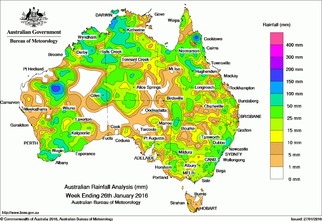
A number of troughs and associated lows brought rainfall to large parts of Australia over the past week.
At the beginning of the week, an upper-level and surface trough triggered thunderstorms over the central and interior parts of Western Australia. A complex low pressure system moved across the southern coast and brought moderate to heavy falls to the South West Land Division and southern Goldfields of Western Australia. A surface trough extended from the Northern Territory to southeastern Australia, and was responsible for cloud and embedded thunderstorms over the Northern Territory, most parts of South Australia, southern parts of New South Wales and over Victoria.
In the middle of the week, a number of troughs and an associated low moved through South Australia and into Victoria. Another trough tracked east over southwest Queensland and New South Wales, with a low forming near the coast. Warm and humid air feeding into this trough generated widespread moderate falls over southern and eastern New South Wales, and eastern Victoria.
In the last part of the week, a deepening surface trough near the west coast of Western Australia produced thunderstorms with moderate to heavy falls recorded from the Pilbara down to the South West Land Division. In the east, a broad area of low pressure triggered thunderstorms over much of northern and eastern Queensland, and eastern New South Wales, with moderate falls recorded. Heavier falls were recorded over central Queensland. Areas of low cloud lingered near the coasts of Victoria and Tasmania, with light rain falling due to an onshore airstream.
Scattered thunderstorm activity over northern Australia brought moderate to heavy falls to the Kimberley, Top End, Gulf Country and the Cape York Peninsula as a monsoon trough developed north of Australia during the week.
Rainfall totals exceeding 100 mm were recorded in the western Top End, parts of inland Pilbara and west Kimberley in Western Australia, areas of the Manning district in New South Wales, and in isolated pockets of the Cape York Peninsula and north tropical and central coasts in Queensland. The highest weekly total was 199 mm at Yarras in New South Wales.
Rainfall totals between 50 mm and 100 mm were recorded in the Kimberley, Pilbara, Gascoyne and isolated parts of central and southwest Western Australia, the northwest, southwest and central parts of the Northern Territory, parts of northern and central Queensland along with small parts in the southeast and southwest, and isolated parts of the central coast of New South Wales.
Rainfall totals between 10 mm and 50 mm were recorded in most of the western half and northern Western Australia, most of the Northern Territory except the southeast corner, northern, southern and parts of southeastern South Australia, most of Queensland except the far southwest and areas in the Herbert and Lower Burdekin district, most of New South Wales apart from the northwest, most of Victoria away from the southwest, and a small area in southwest Tasmania.
Little or no rainfall was recorded this week in central and southeastern parts of Western Australia, western, central and northeastern South Australia, far southwestern Queensland, a small area in the southeast of the Northern Territory, and most of Tasmania.
New South Wales and Australian Capital Territory
199 mm Yarras (Mount Seaview)
131 mm Craven (Longview)
127 mm Mount George (Manning River)
Victoria
60 mm Natimuk
50 mm Cann River, Dimboola
Queensland
144 mm Laura Post Office
119 mm Cairns Aero
116 mm Carfax
Western Australia
136 mm Weelarrana
135 mm Fitzroy Crossing Aero
133 mm Bulloo Downs
South Australia
64 mm Sandalwood (280 Gowling Road)
46 mm Brownhill Creek (Scotch College)
41 mm Uraidla
Tasmania
17 mm Maatsuyker Island Lighthouse, Deal Island
16 mm Fern Tree (Grays Road)
Northern Territory
146 mm Geriatric Park (Dundee Downs), Upper Seventeen Mile Creek
More weekly rainfall totals:
- NSW/ACT totals click here
- Vic totals click here
- Qld totals click here
- WA totals click here
- SA totals click here
- Tas totals click here
- NT totals click here
Source: BOM


HAVE YOUR SAY