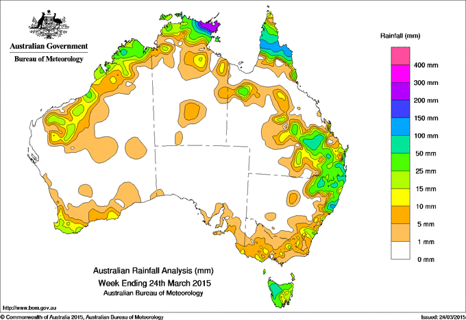
Rainfall recorded across Australia over the past seven days.
Showers and thunderstorms delivered some handy rainfall to a footprint stretching from northern New South Wales and south East Queensland into Central Queensland during the week.
At the beginning of the week, tropical cyclone Nathan was located northeast of Cooktown, on Queensland’s northern coast. The cyclone intensified before making landfall early on the 20th between Cape Melville and Cape Flattery as a category 4 system. Heavy rainfall was recorded along the north tropical coast and across the Cape York Peninsula during the middle of the week as the cyclone passed. Tropical cyclone Nathan then tracked through the Gulf of Carpentaria and crossed the eastern Top End coast on the 22nd, bringing heavy rainfall to eastern parts of the Top End in the Northern Territory during the last days of the week.
At the start of the week a complex low pressure system south of the Great Australian Bight swept a series of cold fronts and a broad trough through southeastern Australia, bringing moderate falls to southwest Western Australia followed by isolated thunderstorms over southeastern South Australia, western Victoria with moderate falls across Tasmania. An area of moderate rainfall recorded in northeastern New South Wales at the start of the week was also associated with a surface trough.
During the middle of the week surface troughs triggered showers and thunderstorms over inland southeastern Queensland and northeastern New South Wales, resulting in generally moderate rainfall totals in some areas.
At the end of the week, a cold front tracked across southeastern Australia, with an associated rainband generating moderate rainfall totals in western and northern Tasmania and light falls in southeastern New South Wales and isolated parts of southern Victoria. A broad area of low pressure over the north of Western Australia also brought moderate to heavy rainfall to the Kimberly and Pilbara regions.
Rainfall totals in excess of 150 mm were recorded in the northeastern Top End. Higher totals in excess of 200 mm observed in Arnhem Land, including the highest weekly total of 410 mm at Nhulunbuy.
Rainfall totals between 50 mm and 150 mm were recorded in coastal parts of the northern Kimberley in Western Australia, the northeastern Top End, across most of the Cape York Peninsula, in parts of southeastern Queensland extending into northeastern New South Wales, and in northwestern Tasmania. A large part of the southern Cape York Peninsula record weekly totals in excess of 100 mm.
Rainfall totals between 10 mm and 50 mm were recorded in a band along the northwest coast of Western Australia, in southwest Western Australia, across the Top End surrounding higher falls, in areas of central and southern Queensland, around higher falls in northeastern New South Wales extending to pockets of southern coastal New South Wales, and isolated locations in southern and eastern Victoria, and southeastern South Australia, as well as remaining parts of Tasmania.
Much of South Australia, northern Victoria, western New South Wales, western and parts of northern Queensland, areas of Western Australia away from the southwest and northwest coasts and the Northern Territory away from the Top End recorded little or no rainfall for the week.
Highest weekly totals in each State:
| State | Highest | 2nd Highest | 3rd Highest |
|---|---|---|---|
| WA | Mount Elizabeth (62 mm)  (North Kimberley) |
Cygnet Bay (57 mm) (West Kimberley) |
Burringurrah Airstrip (49 mm) (East Gascoyne/Murchison) |
| NT | Nhulunbuy (410 mm) (Arnhem) |
Alcan Minesite (374 mm) (Arnhem) |
Gove Airport (308 mm) (Arnhem) |
| SA | Parawa (Sharon) (21 mm) (East Central) |
Murray Bridge Comparison (13 mm) (Murray River) |
Hindmarsh Island (12 mm) (East Central) |
| Qld | Brisbane (158 mm) (Moreton) |
Greenslopes Private Hospital (134 mm) (Moreton) |
Noosaville (134 mm) (Moreton) |
| NSW/ACT | Woodenbong (Unumgar St) (166 mm) (Northern Tablelands) |
Killabakh (149 mm) (Manning) |
Wingham (Lanark Close) (145 mm) (Manning) |
| Vic | Wyelangta (44 mm) (West Coast) |
Beech Forest (28 mm) (West Coast) |
Haines Junction (28 mm) (West Coast) |
| Tas | Mount Read (115 mm) (East Coast) |
Quamby Bluff (66 mm) (West Coast) |
Erriba (66 mm) (Northern) |
Source: Bureau of Meteorology
HAVE YOUR SAY