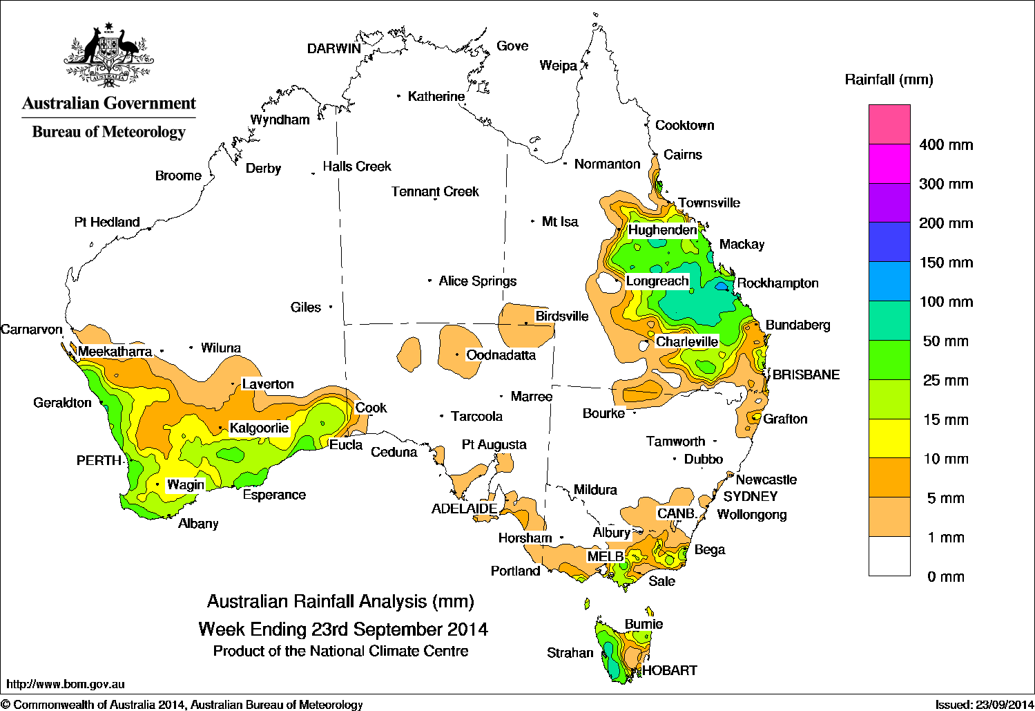
Rainfall received across Australia for the week to yesterday. Click on map to view in large format.
Rainfall was recorded over central Queensland, eastern parts of Victoria, Tasmania, and southern Western Australia.
At the beginning of the week, a low pressure system located in the southern Tasman Sea extended a trough through to northern Queensland. Light to moderate daily totals were recorded over eastern Victoria, southeastern New South Wales, and in Tasmania’s northwest and west.
During the middle of the week a series of surface troughs and cold fronts crossed the Great Australian Bight, bringing moderate rainfall totals to Tasmania’s west coast with light falls extending through to southern Victoria.
During the latter part of the week, a deepening surface trough located over Queensland brought light to moderate falls for the central interior, followed by widespread rainfall with moderate totals in most of the southeast quarter of the state. Isolated areas of heavier falls were recorded in Queensland’s Central Highlands district. A strong cold front and associated cloudband crossed southern Western Australia at the end of the week resulting in moderate falls being recorded in areas along the southwest coast.
Rainfall totals over 50 mm were reported in the Capricornia coast and adjacent inland districts in central Queensland, with isolated areas along the coast receiving over 100 mm. Parts of the west coast in Tasmania also received totals over 50 mm.
Rainfall totals between 15 mm and 50 mm were recorded in the west and north of Tasmania, eastern parts of Victoria, and in the western and southern coastal parts of Western Australia.
Rainfall totals between 10 mm and 15 mm were recorded in areas surrounding higher falls in southwest Western Australia, parts of eastern Victoria, northeastern Tasmania and in southeastern Queensland.
The Northern Territory, remaining parts of northern Western Australia, South Australia, most of New South Wales, northwestern Victoria and inland and far northern Queensland away from coast recorded little or no rainfall for the week.
Late season El Niño remains possible
Despite most ocean and atmospheric indicators falling short of El Niño thresholds, model outlooks and recent observations indicate that a late El Niño remains possible. The Bureau’s ENSO Tracker indicates there is at least a 50% chance of El Niño developing over the coming months, which is double the long-term likelihood.
The Southern Oscillation Index (SOI) has now remained negative for several weeks, and some renewed warming has occurred across the equatorial Pacific Ocean over the past fortnight. Both support the possibility of an El Niño becoming established in the months ahead. Six of the eight international climate models surveyed by the Bureau indicate El Niño, or near El Niño, conditions are likely for the southern summer.
El Niño is often associated with below-average rainfall over large parts of southern and eastern inland areas of Australia and above-average daytime temperatures over southern Australia. Such impacts can often occur while an event is developing, as experienced in some locations over the past several months.
The Indian Ocean Dipole (IOD) in the tropical Indian Ocean continues to show signs that it has returned to a neutral state. Waters to the north of Australia and in the Timor Sea are now at near-average temperatures. All climate models surveyed by the Bureau indicate the IOD will continue to weaken, with neutral conditions likely to become well established during the coming months.
Highest weekly rainfall totals by state
| State | Highest | 2nd Highest | 3rd Highest |
|---|---|---|---|
| WA | Howatharra (63 mm) (North Coast) |
Moascar (62 mm) (North Coast) |
The Duke (56 mm) (South Coast) |
| NT | Nil rainfall recorded | ||
| SA | Neptune Island (10 mm) (Western Agricultural) |
Meningie (10 mm) (Murray River) |
Williamstown (9 mm) (East Central) |
| Qld | Melrose (120 mm) (Port Curtis) |
Broadmeadows (115 mm) (Port Curtis) |
Yaamba (100 mm) (Port Curtis) |
| NSW/ACT | Merimbula (39 mm) (South Coast) |
Candelo Post Office (34 mm) (South Coast) |
Grafton (25 mm) (Upper North Coast) |
| Vic | Mount Baw Baw (52 mm) (West Gippsland) |
Labertouche (40 mm) (West Gippsland) |
Walhalla (35 mm) (Upper Northeast) |
| Tas | Mount Read (117 mm) (West Coast) |
Lake Margaret (96 mm) (West Coast) |
Strahan (Andrew Street) (81 mm) (West Coast) |
Source: BOM
HAVE YOUR SAY