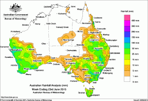
 Rainfall totals during the past week between 50 mm and 100mm were recorded along the west and south coast of Western Australia, parts of eastern New South Wales including Sydney, pockets of Gippsland in Victoria, inland southern and tropical east coast of Queensland, as wellas Kangaroo Island and the southern Eyre Peninsula in South Australia. Some locations on the west coast and in eastern Australia received weekly totals in excess of 100 mm.
The highest weekly total was 170 mm at Steep Point in the western Gascoyne in Western Australia.
Rainfall totals between 10 mm and 50 mm were recorded over a large part of Western Australia southwest of a line from Onslow to Eucla, between the Eyre Peninsula and North East Pastoral districts in South Australia, across most of New South Wales, eastern and coastal southwestern Victoria, southeast to central, and parts of the tropical east coast of Queensland, and nearly all of Tasmania.
At the start of the week, a surface trough combined with a complex low over southeastern Australia triggered thunderstorms and showers. Moderate to heavy rainfall was recorded in Queensland’s southeast quadrant and much of New South Wales. Light to moderate rainfall was also observed in parts of eastern South Australia, Victoria and Tasmania during the early part of the week in a moist southeast flow.
In Western Australia, a cloudband over the west coast produced isolated thunderstorms with moderate to heavy rainfall over the northwest Gascoyne and adjacent southwest Pilbara.
A cut –off low near southwest Western Australia, brought thunderstorms with widespread showers from the northwest of the State to the South West Land Division in the middle of the week.
In the latter part of the week, a broad cloudband off the northwest, followed by a strong cold front moved across Western Australia, bringing widespread moderate to heavy rainfall to western and central Western Australia, including the Central Wheat Belt and Great Southern farming regions, and Goldfields.
Some localised moderate falls were recorded along Queensland’s tropical east coast towards the end of the week, associated with onshore flow.
Nearly all the Northern Territory, much of South Australia, western and northern Queensland, northern and eastern Western Australia received little or no rainfall this week.
Highest weekly totals in each State:
- New South Wales and Australian Capital Territory
-
- 120 mmDover Heights (Portland St)
- 110 mmRandwick (Randwick St)
- 105 mmNelson Bay (Nelson Head)
-
- 131 mmMount Wellington
- 118 mmReeves Knob
- 87 mmMount Moornapa
-
- 109 mmMt Sophia
- 100 mmTree House Creek
- 91 mmTully Sugar Mill
-
- 170 mmSteep Point
- 130 mmUseless Loop
- 120 mmEneabba
-
- 85 mmTumby Bay
- 64 mmParndana (Turkey Lane)
- 59 mmParndana Cfs Aws
-
- 49 mmPremaydena Hatchery
- 46 mmFriendly Beaches
- 45 mmEaglehawk Neck (Jetty Road)
-
- 9 mmArltunga
- 7 mmJervois
- 5 mmAlice Springs Desert Park
- 5 mmAlcan Minesite
Source: Bureau of Meteorology

HAVE YOUR SAY