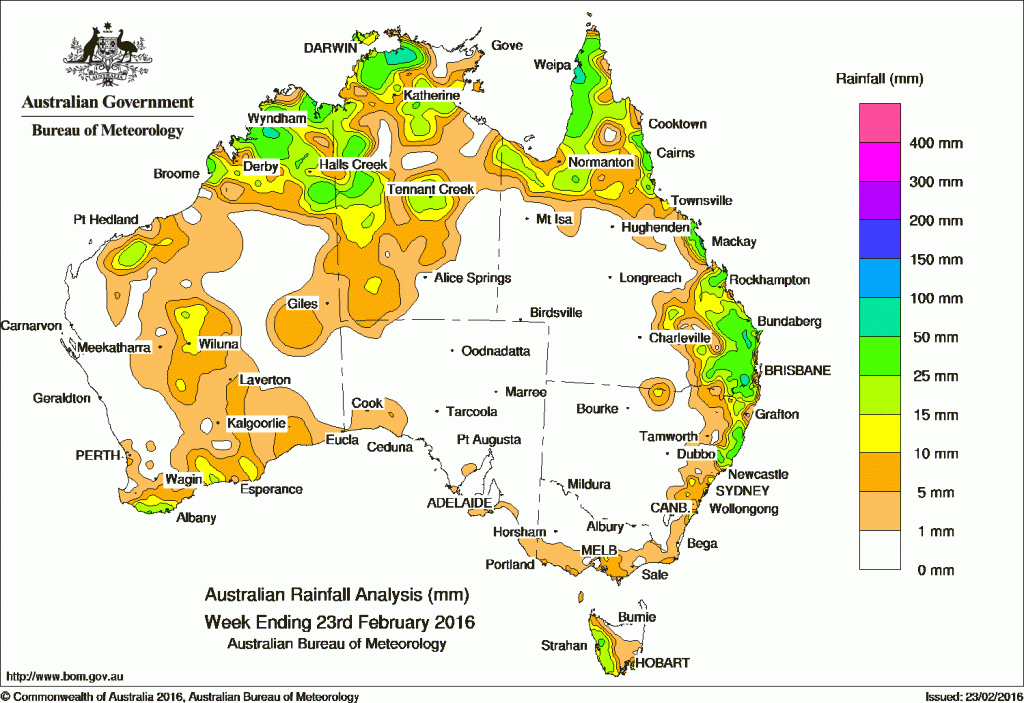
Rain for the past week was restricted mainly to north western Australia, far northern Queensland and parts of the eastern Australian coast.
At the beginning of the week, a high pressure system located south of the Great Australian Bight directed a vigorous southwesterly airstream across western Tasmania and parts of southern Victoria, resulting in light rainfall. A surface trough extended across northern Australia resulted in showers and storms across much of the Top End of the Northern Territory, the Kimberley, the Gulf Country and the Cape York Peninsula.
In the middle of the week, a surface trough extended from the Northern Territory into New South Wales. The slow-moving system produced moderate falls across southeast Queensland, including the Darling Downs, Wide Bay and Burnett districts. Moderate falls were also recorded in northeastern New South Wales. The trough extended south into central New South Wales, bringing moderate falls to parts of the central coast and light falls to the south coast.
At the end of the week, a surface trough and an associated upper-level disturbance produced a band of cloud with embedded thunderstorms extending from the Pilbara district into central and southern Western Australia. Light to moderate falls were recorded throughout parts of the Gascoyne, and in central and southern areas of Western Australia. A surface trough and low pressure system located across the north of the Northern Territory produced moderate falls in the Kimberley, the western border and southwest parts of the Northern Territory. A low pressure trough extending across Queensland and a moist onshore flow brought moderate falls to Cape York Peninsula and the central coast of Queensland.
Rainfall totals between 50 mm and 100 mm were recorded in parts of the Kimberley, the central Top End, parts of the Cape York Peninsula, and southeastern Queensland. Isolated totals exceeding 100 mm were recorded in parts of the southeastern Queensland, including the highest weekly total of 111 mm at Tarome in Queensland.
Rainfall totals between 10 mm and 50 mm were recorded in the Kimberley, inland east Pilbara, and along the southern parts of Western Australia. Similar totals were recorded along the western border, central parts and across the Top End of the Northern Territory; also across the Gulf Country and the Cape York Peninsula. Totals between 10 mm and 50 mm were also recorded in southeastern Queensland and northeastern New South Wales, a small area of southern central Victoria, and in western Tasmania.
Most of the west coast and eastern Western Australia, South Australia, the southwest of the Northern Territory; western, central and southern Queensland, inland New South Wales, remaining parts of Victoria, and central and eastern Tasmania recorded little or no rainfall this week.
Highest totals in each State and Territory:
New South Wales and Australian Capital Territory
95 mm Nymboida (Nymboida River)
78 mm Moppy Lookout (Barrington Tops
77 mm Bowra Sugarloaf
Victoria
19 mm Ferny Creek
18 mm Mount Baw Baw
17 mm Lilydale
Queensland
111 mm Tarome
97 mm Alderley
96 mm Miva
Western Australia
73 mm Wyndham Aero
68 mm Mount Elizabeth
53 mm Mornington
South Australia
13 mm Parawa (Second Valley Forest A
11 mm Parawa (Sharon)
5 mm Goolwa Barrage, Lake George, Kingscote
Tasmania
56 mm Mount Read
31 mm Lake Margaret Power Station
30 mm Scotts Peak Dam, Queenstown (South Queenstown)
Northern Territory
92 mm Dum In Mirrie Airstrip
68 mm Elizabeth Valley
63 mm Oenpelli Airport, Point Stuart, Jabiru Airport
More weekly rainfall totals:
- NSW/ACT totals click here
- Vic totals click here
- Qld totals click here
- WA totals click here
- SA totals click here
- Tas totals click here
- NT totals click here
Source: BOM


HAVE YOUR SAY