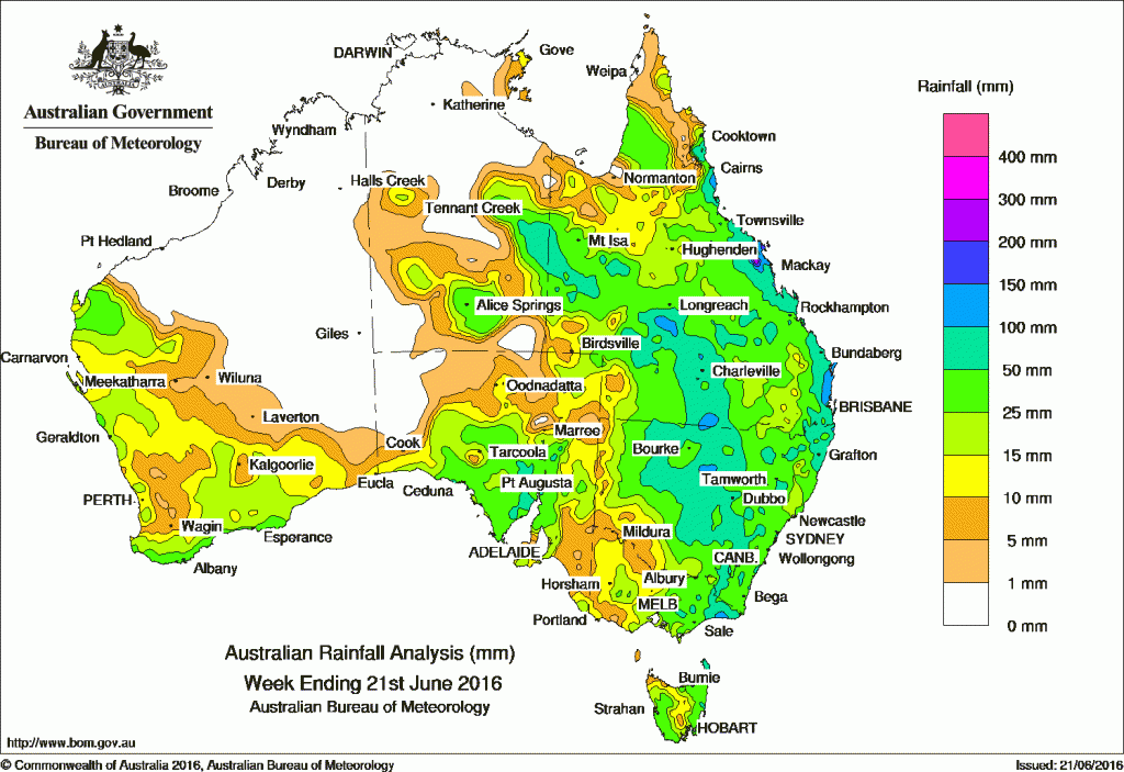
Widespread, moderate falls were recorded across much of Queensland and New South Wales, eastern and central Victoria, western Tasmania, southern and central areas of South Australia, eastern and southern areas of the Northern Territory and southern areas of Western Australia.
At the start of the week, a low pressure system and surface trough moved slowly across southern parts of Western Australia and produced moderate falls in the Goldfields and along the southern coast. The low pressure system tracked over the Great Australian Bight with the associated surface trough extending into South Australia. Moderate rainfall totals were recorded in the Northwest Pastoral district and in parts of the Eyre and Yorke Peninsulas. Middle-level cloud extended into western Victoria and western New South Wales, producing moderate rainfall in northwestern New South Wales, parts of northern Victoria, and western Tasmania as a weak cold front also tracked across Tasmania.
By the middle of the week, a cloudband formed east of a deep surface trough located over western Queensland and New South Wales. The trough moved eastwards, generating thunderstorms and widespread rainfall, with moderate rainfall totals in the southern interior of the Northern Territory, western and southern Queensland, and northern and central New South Wales.
An upper-level trough intensified as it tracked east into western Queensland, resulting in a deepening of a surface tough over the interior of Queensland and northern New South Wales. Widespread, moderate falls were recorded across most of Queensland. As the system continued to move eastwards, and a low pressure centre developed over central New South Wales, generating moderate to heavy falls across large parts of eastern Australia, including eastern Victoria.
A moist, onshore southeasterly flow brought persistent shower activity to Queensland’s north tropical coast during the week.
Rainfall totals between 50 and 100 mm were recorded in parts of the Eyre Peninsula and southern parts of the Northwest Pastoral districts in South Australia, parts of the elevated areas of the Victorian Alps and Snowy Mountains in New South Wales, and in central and northern New South Wales. Similar totals were recorded in western and central Queensland extending just across the Northern Territory and Queensland border, and along the east coast of Queensland and northeastern New South Wales. Totals in excess of 100 mm were recorded in Queensland’s central west, and along its north tropical, central and southeast coasts.
Rainfall totals between 10 mm and 50 mm were recorded in southwest and southern Western Australia, central and northeastern areas of South Australia, most of Victoria except the western areas, and in western and northern Tasmania. Similar totals were recorded across most of New South Wales, Queensland, and in southern and eastern parts of the Northern Territory.
Remaining parts of Western Australia, the northwest of South Australia and the north and west of the Northern Territory recorded little or no rainfall this week.
Highest weekly totals in each State and Territory
New South Wales and Australian Capital Territory
124 mm Mullumbimby (Fairview Farm)
115 mm Bangalow (Fowlers Lane), Murwillumbah
Victoria
147 mm Cabbage Tree Creek
127 mm Cape Conran (Yeerung Park)
105 mm Orbost
Queensland
186 mm Oakpark
164 mm Peachester
159 mm Mount Jukes
Western Australia
51 mm Walpole
49 mm Denmark
47 mm Walpole Forestry
South Australia
138 mm Whyalla (Mullaquana)
81 mm Cleve
76 mm Cleve Aerodrome
Tasmania
73 mm Memana (Babel Farm)
55 mm Friendly Beaches
53 mm Bicheno (Council Depot)
Northern Territory
57 mm Alice Springs Desert Park
53 mm Undoolya
52 mm Trephina Gorge
More weekly rainfall totals:
- NSW/ACT totals click here
- Vic totals click here
- Qld totals click here
- WA totals click here
- SA totals click here
- Tas totals click here
- NT totals click here
Source: BOM


HAVE YOUR SAY