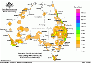
Slideshow of the past 10 weekly rainfall maps in order from August 19, 2015 to October 20, 2015. Click on buttons below right of image to control slideshow.
 Rainfall over the past week was recorded in southeastern and southern Queensland as well as the north tropical Queensland coast, parts of eastern and northern New South Wales, southwest Western Australia, a small part of the coast of southeastern South Australia and western Tasmania.
At the beginning of the week a surface trough extended from southern Queensland to northeastern New South Wales producing showers and thunderstorms with moderate rainfall totals in northeastern New South Wales and widespread light to moderate rain across the southeastern quarter of Queensland.
Light rainfall was recorded in parts of the Southwest Western Australia as a cold front connected to an intense low pressure system over the Southern Ocean track across the Great Australian Bight. Light rainfall was recorded in western Tasmania as this cold front and trough tracked across Bass Strait..
In the middle of the week, a cloudband associated with a surface trough extended from the interior of Western Australia to the southeast of the continent. Isolated thunderstorms embedded within the cloudband produced localised, light rain totals in parts of central Western Australia, the Pilbara, South Australia and central New South Wales.
During the last part of the week, a deep surface trough extended across Western Australia, a cold front that followed the trough tracked across the southwest, producing light to moderate falls in the far southwest of Western Australia.
Meanwhile, a moist southeasterly airstream was directed across the north tropical Queensland coast bringing isolated, moderate falls to the area extending between the Whitsunday Islands and Cooktown in northern Queensland.
Rainfall totals in excess of 50 mm were recorded in parts of the north tropical Queensland coast, and on the central New South Wales coast. The highest weekly total was 76 mm at Kempsey in New South Wales.
Rainfall totals between 10 mm and 50 mm were recorded in southwest and the south coast of Western Australia, a small area of coastal southeast South Australia, and an area of western Tasmania. Similar totals were recorded in southeastern and southern Queensland, and along the north tropical and central coasts of Queensland.
Most of Western Australia, the Northern Territory, South Australia, Victoria, western and southern New South Wales, eastern Tasmania, and a large area of northern, central and western Queensland away from the southeast and north tropical coasts recorded little or no rainfall this week.
New South Wales and Australian Capital Territory
76 mm Kempsey Airport AWS
75 mm Wittitrin
63 mm Yarras (Mount Seaview)
Victoria
6 mm Tubbut, Annuello
5 mm Pira Wild Horse Plains. Ouyen (Post Office). Falls Creek
Queensland
65 mm South Johnstone Exp Stn
62 mm Victoria Sugar Mill
58 mm Crows Nest John St
Western Australia
33 mm Willare Bridge
29 mm Anketell
27 mm Jarrahdale
South Australia
9 mm Lenswood (Stringybark), Ashton
8 mm Lobethal Woodside (Wicks Estate), Montacute
Tasmania
23 mm Mount Read
13 mm Butlers Gorge
12 mm Queenstown (South Queenstown)
Northern Territory
6 mm Dum In Mirrie Airstrip
5 mm Charles Point
4 mm Thorak Cemetery
More weekly rainfall totals:
NSW/ACT totals click here
Vic totals click here
Qld totals click here
SA totals click here
Tas totals click here
NT totals click here
Source: BOM

HAVE YOUR SAY