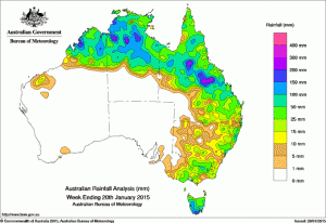
Some further good falls of rain across northern and eastern Australia have helped to consolidate a wetter than expected start to the year for many livestock producers in the past week.
However, most of Western Australia, South Australia, the south of the Northern Territory and the area between southwestern Queensland and northwestern Victoria recorded little or no rainfall for the week.
At the start of the week, a strong low was located off Tasmania’s east coast, with an associated pressure trough extending into Queensland where it connected with the monsoon trough across northern Australia. Rainfall across Victoria, southern New South Wales and Tasmania was recorded on the first day of the week. Very heavy rain in southeastern Tasmania fell on the morning of the 14th resulted in storm damage and some flooding.
In the north, frequent showers and storms were recorded across eastern and northern Queensland, the northern half of the Northern Territory and across the Kimberley in Western Australia. Some of these storms brought very heavy rain, with flash flooding reported in parts of north and north-west Queensland at mid-week.
Cold fronts crossing Tasmania in the second half of the week brought moderate rainfall totals to the east coast.
At the end of the week the monsoon trough weakened as a tropical low developed over the Kimberley before moving off shore of the Pilbara coast. This low was associated with very heavy rainfall and flash flooding in parts of the Kimberley.
During the last day of the week, surface troughs over the eastern mainland combined with onshore flow to generate moderate rainfall along the coast in the northern half of New South Wales and in southeastern Queensland, with some areas of heavy falls in New South Wales.
Rainfall totals in excess of 100 mm were recorded in parts of the Kimberley, large areas of the north of the Northern Territory, parts of inland northern Queensland, western and southern Tasmania and a small pocket on New South Wales’ Lower North Coast. The highest weekly total was 264 mm at Dum In Mirrie Airstrip in the Darwin–Daly District of the Northern Territory. A scattering of other locations in the areas listed recorded totals in excess of 150 mm or 200 mm.
Rainfall totals between 10 mm and 50 mm were recorded surrounding areas of higher falls and across the remainder of northern and eastern Queensland, eastern to central New South Wales, much of Victoria except the northwest, and the remainder of Tasmania. Small parts of the Pilbara coast and southeastern South Australia also recorded weekly totals in excess of 10 mm.
Highest weekly totals by State
| State | Highest | 2nd Highest | 3rd Highest |
|---|---|---|---|
| WA | Warmun (246 mm) (East Kimberley) |
Willare Bridge (163 mm) (West Kimberley) |
Napier Downs (155 mm) (West Kimberley) |
| NT | Dum In Mirrie Airstrip (263 mm) (Darwin-Daly) |
Timber Creek (228 mm) (Victoria) |
Walker Creek (214 mm) (Darwin-Daly) |
| SA | Price (18 mm) (West Central) |
Millicent (17 mm) (Lower Southeast) |
Ashton (12 mm) (East Central) |
| Qld | Frankfield Station (202 mm) (Central Lowlands) |
Eastmere (171 mm) (Central Lowlands) |
Carmichael (171 mm) (Central Lowlands) |
| NSW/ACT | Kalang (Kooroowi ) (227 mm) (Lower North Coast) |
Kalang (Spicketts Ck ) (172 mm) (Lower North Coast) |
Cooks Ck (Kalang) (146 mm) (Lower North Coast) |
| Vic | Wyelangta (83 mm) (West Coast) |
Benwerrin (75 mm) (West Coast) |
Boonah (71 mm) (West Coast) |
| Tas | Mount Wellington (198 mm) (Southeast) |
Leslie Vale (179 mm) (Southeast) |
Longley (176 mm) (Southeast) |
Source: Bureau of Meteorology


HAVE YOUR SAY