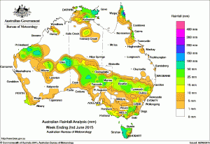
 A band of rain delivered falls of between 10mm and 50mm across northern New South Wales and northern South Australia over the past week.
The week began with showers developing over the Pilbara and surrounds, extending inland along a broad, slow-moving cloudband associated with an upper level trough.
The system went on to produce moderate falls over parts of northern South Australia throughout the week, yielding cumulative totals more than the monthly average in two to three days at some locations.
In the second half of the week light to moderate falls were also recorded across northern New South Wales.
The Top End received moderate falls around the middle of the week, as a southerly dip in an offshore trough brought showers and storms to the region, while the tip of the Cape York Peninsula recorded moderate to heavy rainfall in generally easterly flow.
Northern Tasmania received light falls early in the week as cold fronts crossed the southeast, with light to moderate falls continuing over western Tasmania and parts of the mainland southeast, associated with the passage of a cold front and a cold outbreak with deep southerly winds driven through eastern Australia ahead of a high pressure system which was over the east of the Great Australian Bight at the end of the week.
Parts of southwest Western Australia received some light to moderate falls at the end of the week as a cold front crossed the region.
Weekly rainfall totals in excess of 100 mm were observed in locations on the east coast of the northern Cape York Peninsula, the coastal Top End, the coastal Pilbara, and in western Tasmania. The highest weekly total was 145 mm at Yirrkala Tropical Gardens at the eastern tip of the Top End.
Rainfall totals between 50 mm and 100 mm were recorded in parts of the Pilbara, around Giles in Western Australia, in the eastern Top End, parts of the east coast of the far northern Cape York Peninsula, and across most of the western half of Tasmania.
Rainfall totals between 10 mm and 50 mm were recorded along a line extending through the Pilbara, parts of Western Australia’s interior, most of the northern half of South Australia and adjacent areas across the border of the Northern Territory, and through most of northern New South Wales.
Weekly totals of 10 mm to 50 mm were also received in far southwest Western Australia, pockets of the western Kimberley and the north of the Northern Territory, more broadly in the central to eastern Top End, in parts of Queensland’s tropical coast between Townsville and Cooktown, across the northern half of Tasmania, in southeastern South Australia and southwestern Victoria, and along the Great Dividing Range between South Gippsland in Victoria and the Central Tablelands in New South Wales. Most of Queensland, southwestern and coastal southern New South Wales, northwestern Victoria, southern and far western South Australia (except for the southeast), much of Western Australia (except for the Pilbara, southern Interior and far southwest), and most of the Northern Territory south of the Top End recorded little or no rainfall during the week.
Highest weekly rainfall totals in each State:
-
- 67 mmPerisher Valley Aws
- 54 mmRowena Post Office
- 51 mmCabramurra Smhea Aws
- 51 mmHanging Rock (Andeva)
-
- 57 mmWyelangta
- 56 mmBeech Forest
- 54 mmHaines Junction (Mount Sabine)
- 54 mmCape Conran (Yeerung Park)
-
- 124 mmLockhart River Airport
- 98 mmHorn Island
- 81 mmCoconut Island
-
- 122 mmIndee
- 62 mmBonney Downs
- 62 mmGiles Meteorological Office
- 56 mmRoebourne Aero
-
- 42 mmArkaroola
- 41 mmMount Barry Station
- 40 mmMintabie
-
- 112 mmMount Read
- 102 mmLake Margaret Power Station
- 101 mmQueenstown (South Queenstown)
-
- 145 mmYirrkala Tropical Gardens
- 100 mmWarruwi Airport
- 90 mmAlcan Minesite
Mount Read was affected by snow during the last two days of the week. The true total is unknown but will be higher as it includes snow yet to melt.
Source: BOM

HAVE YOUR SAY