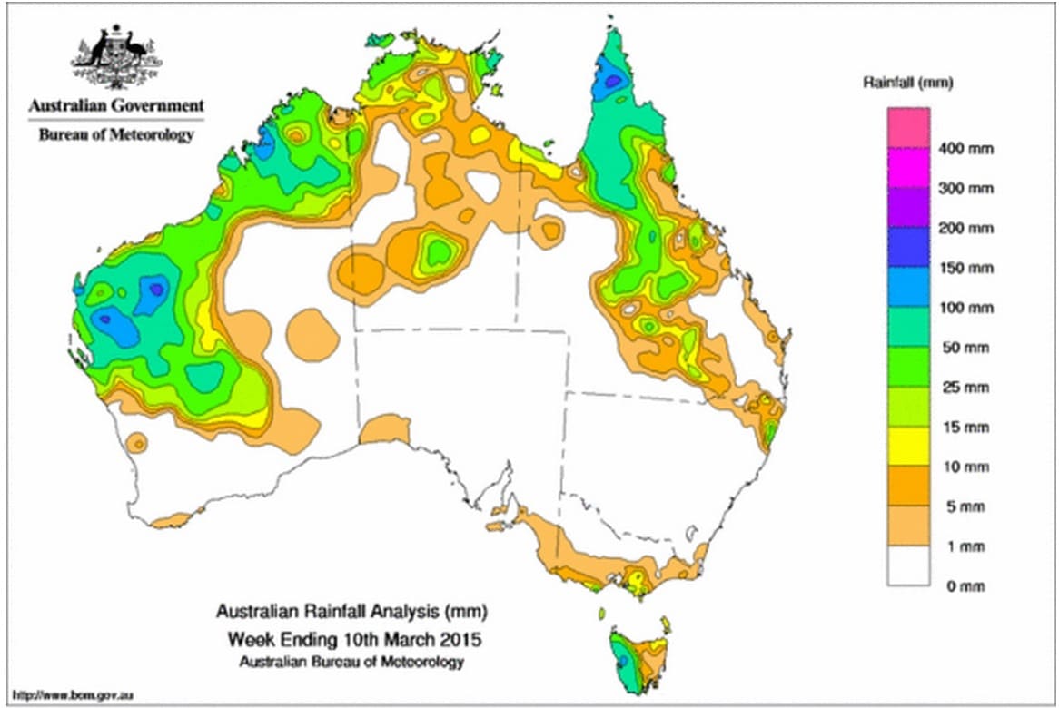
GOOD rainfall was recorded in parts of the Kimberley, Pilbara and Gascoyne districts of Western Australia and the north of the Cape York Peninsula over the past week, while southern Australia generally received little moisture.
The exception was Tasmania’s west coast, where Mt Read recorded the nation’s highest weekly total of 232 mm.
At the beginning of the week, a broad surface trough was located across inland parts of the Pilbara and Kimberley, along with a tropical low off the WA Pilbara coast. Moderate to heavy falls were recorded across the Pilbara and Gascoyne, and moderate totals in the Kimberley.
A slow-moving surface trough extended over western Queensland, generating moderate totals across much of the Cape York Peninsula.
A strong cold front tracked across Tasmania and produced moderate rainfall totals in western Tasmania, and light falls in parts of southern Victoria and the southeast coast of South Australia.
In the middle of the week, thunderstorms and showers continued to form about the Kimberley and Pilbara coasts of WA due to the lingering low pressure trough extending along the west coast. An active area of storm activity also occurred over central Australia. Moderate to heavy rainfall totals continued to accumulate in much of the Pilbara, Gascoyne and Goldfields in WA, and across the northern Cape York Peninsula. The interior of the NT recorded moderate rainfall totals north of Alice Springs.
Moist and humid winds continued to feed into a low pressure trough across northern Australia, with moderate to heavy falls recorded in the Kimberley, across the Top End and large parts of Cape York. A surface trough extending from the northwest to southeast interior of Queensland produced moderate rainfall totals through the State’s northern interior.
Late in the week, isolated convective activity about parts of northern WA and in a line stretching from Cape York Peninsula to the southern interior of Qld brought moderate falls in the western Kimberley, the western Top End, large parts of Cape York extending down through inland and southern Qld.
A series of cold fronts tracked across Tasmania and southeast Australia during the second half of the week, producing moderate rainfall totals in western Tasmania during the middle of the week followed by light falls in Tasmania, southern and southwest Victoria and moderate falls on Tasmania’s west coast at the end of the week.
Rainfall totals between 50mm and 100mm were recorded across large areas of the Gascoyne, Pilbara and Kimberley, and parts of the Goldfields districts in Western Australia, much of the Cape York Peninsula and most of western Tasmania.
Rainfall totals between 10mm and 50mm were recorded across most of northern WA, the western half of WA north of the Central Wheat Belt, most of the Top End and parts of the interior of the NT, through the interior of central and southern Qld, in a small area of southeastern Qld and northeastern NSW, parts of central southern Victoria, and in the west and northeast of Tasmania.
Most of South Australia, Victoria away from the southern coast, southern and inland WA, the south and interior of the NT, nearly all of NSW, large parts of western and south Qld recorded little or no rainfall for the week.
Source: Bureau of Meteorology


HAVE YOUR SAY