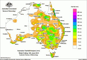
 Some useful falls of rain were recorded in dry areas of north western and south western Queensland, western NSW, western Victoria and South Australia in the past week.
Earlier this week a surface trough and low formed and moved across the south of Western Australia and South Australia, producing showers with light to moderate falls to southern Western Australia and central South Australia.
A cloudband associated with a middle level trough developed over eastern parts of the Northern Territory and South Australia.
The system strengthened while tracking east into western parts of Queensland, New South Wales and Victoria. Showers and thunderstorms with moderate rainfall were recorded in southern, Arnhem Land and Barkly districts of the Northern Territory, the eastern Pastoral districts of South Australia, southern Queensland, western and central New South Wales, western and northern Victoria, and western Tasmania.
An established high pressure system in southeastern Australia directed an easterly flow along the east coast, producing a string of moderate falls along the tropical east coast of Queensland down to the central New South Wales coast.
Rainfall totals between 50 mm and 100 mm were recorded along Queensland’s tropical east coast and northwest, with some locations receiving weekly totals in excess of 200 mm. The highest weekly total was 228 mm at Tree House Creek, south of Cairns in Queensland.
Rainfall totals between 10 mm and 50 mm were recorded along the southern Western Australia coast, central and northern parts of South Australia, Arnhem Land and the Barkly districts of the Northern Territory, northwestern and inland southern Queensland, inland New South Wales, western Victoria, and western Tasmania, as well as a long stretch of the east coast from Queensland’s central coast to the southern coast of New South Wales.
Nearly all of Western Australia away from the south coast, the western to central Northern Territory, western parts of South Australia, and eastern Tasmania received little or no rainfall during the week.
Highest weekly totals in each state:
New South Wales and Australian Capital Territory
-
- 51 mmTweed Heads Golf Club
- 48 mmWanaaring (Owen Downs)
- 46 mmBourke Airport Aws
-
- 33 mmBeulah
- 30 mmBeulah West
- 29 mmSwan Hill Aerodrome
-
- 238 mmTree House Creek
- 211 mmInnisfail
- 208 mmDaradgee
-
- 37 mmNannup
- 35 mmCape Leeuwin
- 31 mmHopetoun North
-
- 47 mmWudinna Aero
- 38 mmMinnipa Pirsa
- 32 mmDarke Peak
-
- 36 mmMount Read
- 32 mmLake Margaret Power Station
- 28 mmQueenstown (South Queenstown)
- Northern Territory
- 45 mmMount Skinner
- 45 mmMilingimbi Airport
- 34 mmBenmara
- 21 mmManingrida Airport
Source: Bureau of Meteorology

HAVE YOUR SAY