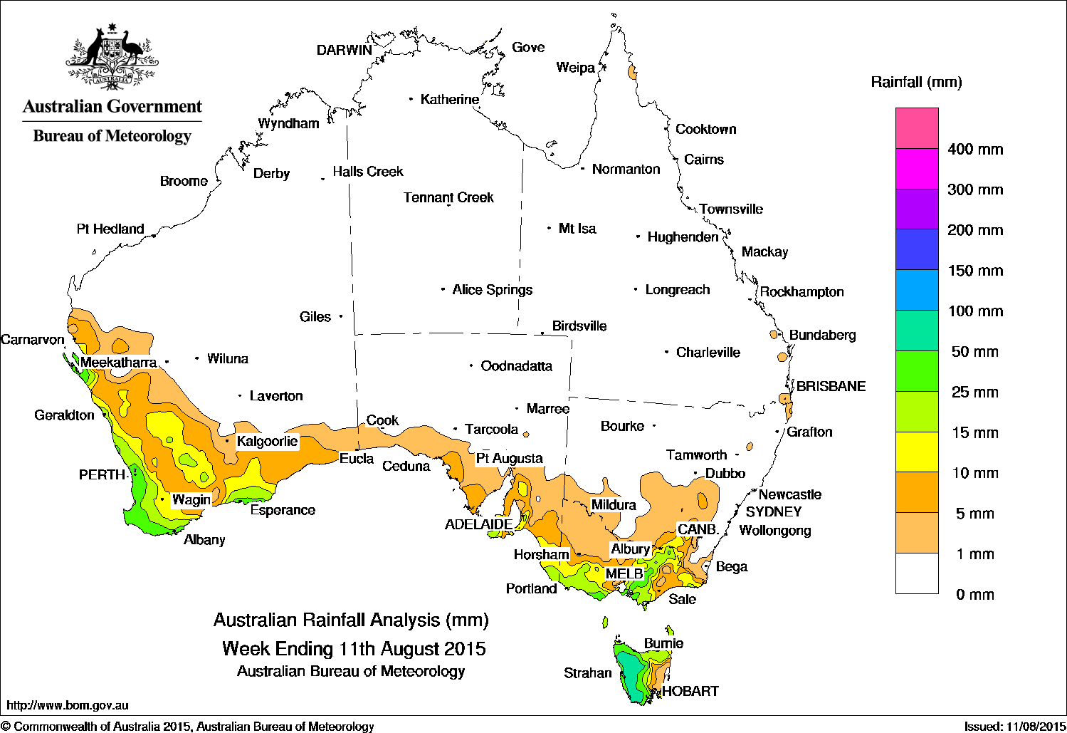
 Most of the continent experienced little to no rainfall over the past week, with the best falls of 50-100mm limted to small areas of south west Western Australia, southern Victoria and western Tasmania.
At the start of the week, a cold front crossed Tasmania and Victoria bringing widespread light rainfall across southeastern South Australia, Victoria, and southeastern New South Wales. Western Tasmania along with parts of southern and alpine Victoria recorded moderate rainfall totals before the system moved off the east coast of Australia.
By the middle of the week, a broad area of low pressure and an upper-level disturbance off the west coast of mainland Australia generated a cloudband extending into southern parts of Western Australia, with light to moderate falls recorded in coastal parts of the Gascoyne and the west coast of Western Australia.
Following the passage of the surface trough, a cold front and an associated cloudband tracked across southern Western Australia and extended south into the South East Coastal district near Esperance.
Areas of embedded thunderstorms forming within the cloudband produced moderate rainfall totals across parts of southwest Western Australia, while lighter rainfall was recorded in parts of the South West Land Division, in eastern South Australia and northern Tasmania. A low pressure centre deepened behind this front, bringing severe weather and moderate falls across northwestern Tasmania.
At the end of the week, another cold front and associated trough swept across southern Western Australia, bringing moderate rainfall to the far southwest of Western Australia, with light rainfall in southeastern South Australia and much of Victoria.
Rainfall totals between 50 mm and 100 mm were recorded in small areas of southwest Western Australia, locations in southern Victoria, and across the west of Tasmania. The highest weekly total was 81 mm at Haines Junction in Victoria.
Rainfall totals between 10 mm and 50 mm were recorded in much of the South West Land Division and around Esperance in Western Australia, in southeastern South Australia, northern and western Tasmania, across most of southern and eastern Victoria, excluding some parts of East Gippsland, and also in parts of southeastern New South Wales.
The Northern Territory, Queensland, most of Western Australia, South Australia away from agricultural areas, parts of northwestern and eastern Victoria and most of New South Wales recorded little or no rainfall.
Highest weekly totals in each state
New South Wales and Australian Capital Territory
18 mm Perisher Valley
16 mm Argalong (Sandy Creek)
16 mm Mullumbimby (Fairview Farm)
16 mm Burrinjuck Dam
Victoria
81 mm Haines Junction (Mount Sabine)
71 mm Mount Baw Baw
62 mm Wyelangta
Queensland
10 mm Canungra Finch Road
3 mm Oxenford (Oberon Way)
3 mm Beaudesert Drumley Street
Western Australia
64 mm Northcliffe
60 mm Useless Loop
54 mm Karri Valley Resort
54 mm Karnet
South Australia
52 mm Bridgewater
29 mm Parawa (Sharon)
27 mm Uraidla
Tasmania
71 mm Warra
70 mm Zeehan
62 mm Mount Read
62 mm Loongana (Serendipity)
62 mm Butlers Gorge
Northern Territory
0.6 mm Centre Island
0.2 mm Gove Airport
Source: BOM
HAVE YOUR SAY