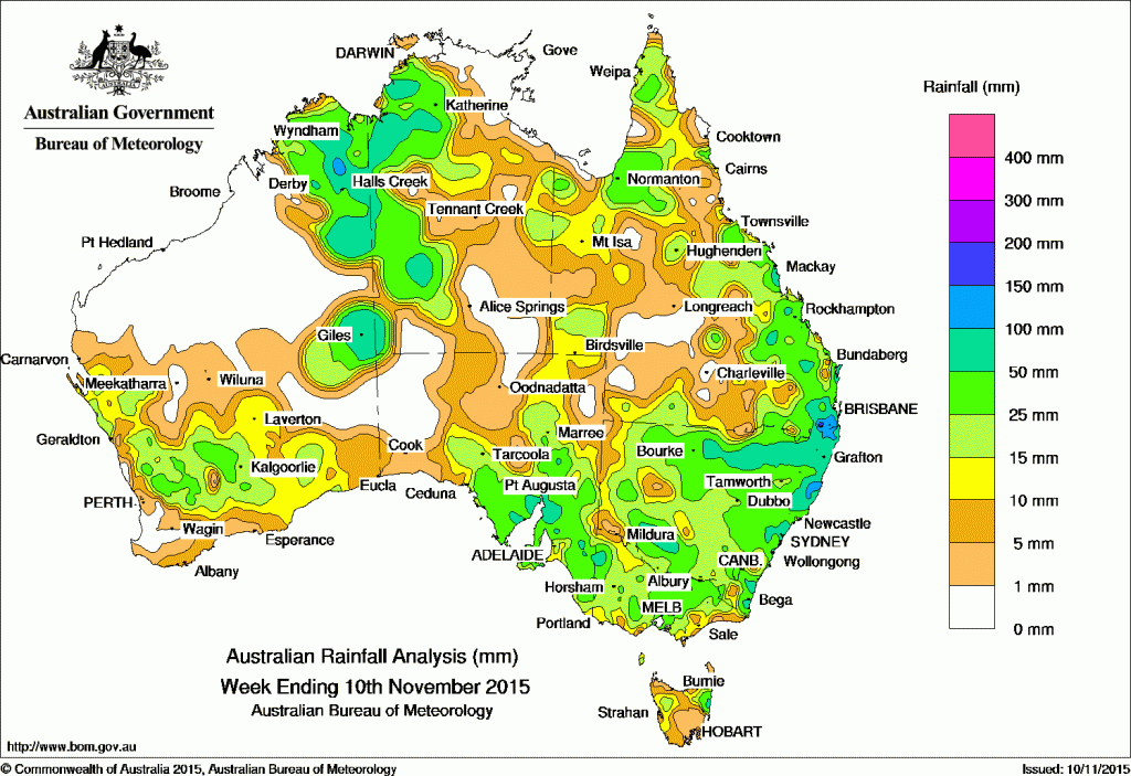
 For the week to 10 November 2015, rainfall was recorded in all States and Territories.
At the beginning of the week, a broad cloudband with embedded thunderstorms extended from the Kimberley in the northwest through central Australia to a deepening low pressure system located over South Australia. Moderate rainfall was recorded across the Eyre Peninsula, West Coast and Pastoral districts of South Australia, central and western parts of the Northern Territory and the northern Kimberley. Another surface trough extended from the Gulf Country, through western Queensland and into northern New South Wales, with showers and thunderstorms forming along the trough.
The low pressure system over South Australia moved eastwards, bringing moderate falls to southeast South Australia, with lighter falls over most of western to central Victoria. The surface trough extending from this low merged with the trough in the east, and deepened over western New South Wales. Moderate to heavy rainfall was recorded in western, central and northern New South Wales, while isolated, moderate totals were recording across northern Australia.
In the middle of the week, areas of low pressure extended across northern and eastern Australia, with low pressure centres forming over the southeast of the continent. Scattered areas of moderate rainfall was recorded in the Kimberley, the Darwin–Daly region in the Northern Territory, and the Gulf Country, with light to moderate falls recorded along most of the eastern coast of the mainland and some parts of central Victoria and northeastern Tasmania.
During the last part of the week, a broad area of low pressure generated a convective cloudband with embedded thunderstorms extending from the Northern Territory through the Kimberley down to the southwest of Western Australia. Moderate falls were recorded in the north of the South West Land Division extending into the Goldfields district, and also in the Kimberley and parts of the northwestern Northern Territory, with isolated storms bringing moderate totals to areas along the Western Australia and Northern Territory border in the last two days of the week.
In the east, a surface trough extended from southeastern Queensland to the Tasman Sea, triggering thunderstorms in parts of eastern Australia and generating moderate rainfall totals in the Cape York Peninsula and along the east coast of Queensland and New South Wales.
Rainfall totals in excess of 100 mm were recorded in parts of northeastern New South Wales, southeast Queensland, and the Kimberley—including the highest weekly total of 190 mm at Drysdale River Station in Western Australia (not visible on map). A small area in southeast Queensland recorded rainfall in excess of 150 mm.
Rainfall totals between 50 mm and 100 mm were recorded in parts of the eastern Kimberley and the eastern interior of Western Australia; in the west of the Northern Territory; areas of the Mid North, Flinders and Eyre Peninsula districts in South Australia; a small area of northwest Victoria; isolated parts of southwest, eastern and northeastern New South Wales; and in parts of southeastern Queensland.
Rainfall totals between 10 mm and 50 mm were recorded in large parts of western, southern and northeastern Western Australia (although missing the southwest), much of the western half of the Northern Territory, the east and south of South Australia, most of Victoria and New South Wales, parts of western and northeastern Tasmania, and eastern and northern Queensland.
Remaining parts of Western Australia, South Australia, the Northern Territory and Queensland recorded little or no rainfall this week.

HAVE YOUR SAY