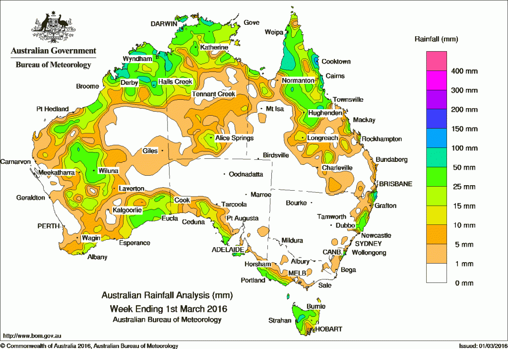
The best falls of rain for the past week were largely confined to far northern Australia, central Western Australia and Tasmania.
At the beginning of the week, a broad area of low pressure produced an area of cloud with embedded thunderstorms that extended from the inland areas of Western Australia and southern South Australia. Moderate falls were recorded in the southwest, Goldfields and Eucla districts of Western Australia, and on the western coastal regions of South Australia. An upper-level trough over the north tropical coast and a surface trough over the Coral Sea produced moderate to heavy falls in parts of northern Queensland, while a surface trough generated showers and thunderstorms across the Top End and Kimberley district.
A cold front tracked across the Great Australian Bight, sweeping the southern coast of southeastern South Australia and western Victoria. A westerly flow produced moderate falls in Tasmania as a cold front approached from the west, with moderate falls recorded across the northern half of the State.
From the middle of the week, a surface trough extended along the west coast of Western Australia, with light to moderate rain falling in western parts of the State, and moderate falls recorded in the Kimberley and bordering areas of the Northern Territory, and the Top End.
At the end of the week, a ridge of high pressure along the coast of New South Wales and an inland trough located over the interior of Queensland and New South Wales produced moderate falls in northeastern New South Wales, and light to moderate falls in parts of the northern interior and central Queensland.
Low pressure troughs were responsible for thunderstorm activity throughout much of the northern Queensland, with moderate falls recorded.
Rainfall totals between 50 mm and 100 mm were recorded in parts of the Kimberley, the Top End, the Cape York Peninsula, northeastern New South Wales and a small pocked in western Tasmania. Isolated totals exceeding 100 mm were recorded in the north tropical coast of Queensland, and the upper north coast of New South Wales, including the highest weekly total of 159 mm at Bangalow.
Rainfall totals between 10 mm and 50 mm were recorded in the north, west and south of Western Australia, areas around Alice Springs in the Top End of the Northern Territory, northern and southern interior parts of Queensland, and along parts of the New South Wales coast. Similar totals were also recorded along coastal areas of South Australia, southwest Victoria, and most of Tasmania except the far southeast.
The interior and parts of the west coast of Western Australia, parts of the southwest and southeast of the Northern Territory, western and southern Queensland, and away for the coasts of New South Wales, South Australia and Victoria recorded little or no rainfall this week.
New South Wales and Australian Capital Territory
159 mm Bangalow (Fowlers Lane), Rosebank (Repentance Creek)
146 mm Nashua (Wilsons River)
Victoria
58 mm Portland (Cashmore Airport)
52 mm Cape Nelson Lighthouse
38 mm Haines Junction (Mount Sabine)
Queensland
153 mm Cooktown Airport
148 mm Bramwell
118 mm Mt Sophia
Western Australia
80 mm Lake Argyle Resort
78 mm Derby Aero
75 mm Lansdowne
South Australia
50 mm Cape Borda, Parndana (Turkey Lane)
48 mm Mount Gambier Council Depot
Tasmania
92 mm Mount Read
68 mm Lake Margaret Power Station
63 mm Queenstown (South Queenstown)
Northern Territory
110 mm Darwin Hospital
100 mm Gunn Point, Stokes Hill
More weekly rainfall totals:
- NSW/ACT totals click here
- Vic totals click here
- Qld totals click here
- WA totals click here
- SA totals click here
- Tas totals click here
- NT totals click here
Further easing of El Niño
The Bureau of Meteorology’s latest ENSO update issued on March 1 said the El Niño remains strong, but is continuing its gradual decline.
Climate models suggest a return to neutral levels in the second quarter of 2016.
Close to the equator, the surface of the Pacific Ocean has now cooled by 0.5 °C since the El Niño peaked in late 2015. Below the ocean surface, cooler than average waters now extend into the central tropical Pacific Ocean. In the atmosphere, trade winds have recently returned to near-normal levels in the central and eastern Pacific, although the Southern Oscillation Index (SOI) has been strongly negative in recent weeks. During Australia’s northern wet season, it is not unusual to see big fluctuations in the SOI due to the passage of tropical systems, and hence its value may not be representative of the overall ENSO state.
Based on the 26 El Niño events since 1900, around 50% have been followed by a neutral year, and 40% have been followed by La Niña. Models suggest the neutral state is most likely for the second half of 2016, followed by La Niña, with a repeat El Niño assessed as very unlikely. Historically, the breakdown of strong El Niño events brings above-average rainfall to some, but not all, parts of Australia in the first half of the year.
The Indian Ocean Dipole has little influence on Australian climate between December and April. However, Indian Ocean sea surface temperatures remain very warm across the majority of the basin which may provide extra moisture for rain systems across Australia.
Source: BOM


HAVE YOUR SAY