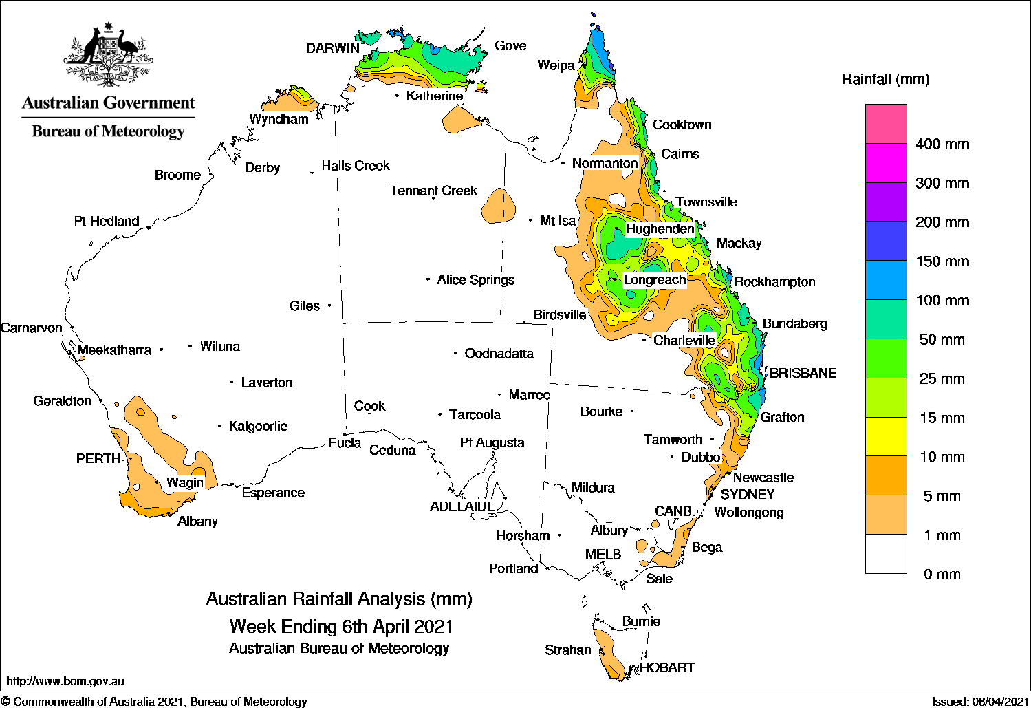
A MONSOON trough developed to the north of Australia this week and produced moderate rainfall in the north Kimberley in Western Australia, the Northern Territory’s top end, the north Cape York Peninsula and north tropical coast in Queensland.
Onshore flows generated light to moderate rainfall from the central and south coast of Queensland to the north and central coast of New South Wales.
During the middle of the week, a tropical low formed well off the north-west of Australia, in the vicinity of the monsoon trough, and later developed to Tropical Cyclone Seroja on 5 April in the Timor Sea, north of Kimberley in Western Australia, and also connected to a tropical low well off the north-west Western Australia, Moderate rainfall continued in the northern Australian tropics.
An inland trough in the central Queensland combined with onshore flows, to produce moderate rainfall in the state’s Northern Goldfields and Upper Flinders, and Central West districts, as well as along the central and south-east coasts, and the adjacent north-east of New South Wales.
At the end of the week, a coastal trough formed off the Queensland coast and a weak low pressure system developed near south-east coast, rainfall increased in the south-east coast and further inland in Queensland and north-east New South Wales.
A broad surface trough in the west of Western Australia triggered isolated thunderstorms with light rainfall for the second part of the week.
Rainfall totals in excess of 100 mm were reported in the north-eastern Arnham District in the Northern Territory; in the northern Cape York Peninsula, tropical north coast and south-east coast in Queensland; in the north-east coast of New South Wales. The highest weekly rainfall was 213 mm at Horn Island at the tip of Cape York Peninsula in Queensland, though Cape Wessel in the north-eastern Arnhem District in the Northern Territory had a higher total at 301.6 mm (not shown in the list).
Rainfall totals between 50 mm and 100 mm were recorded in the coastal Top End in the Northern Territory, areas in the central, and along the east coast of Queensland.
Rainfall totals between 10 mm and 50 mm were recorded in the north Kimberley in Western Australia, the northern Top End of the Northern Territory, the central, south-east inland, and along the east coasts of Queensland; the north-east of New South Wales.
Highest weekly totals
New South Wales and Australian Capital Territory
162 mm Mullumbimby (Fairview Farm)
156 mm Murwillumbah (Dungay (Taleswoo
149 mm Ballina Airport Aws
Victoria
20 mm Falls Creek (Rocky Valley)
4 mm Combienbar Aws
2 mm Mount Moornapa
Queensland
213 mm Horn Island
188 mm Peachester
182 mm Lady Elliot Island
Western Australia
45 mm Troughton Island
23 mm Faraway Bay
20 mm Perenjori
South Australia
0.4 mm Stenhouse Bay, Cape Jaffa (The Limestone)
Tasmania
9 mm Maatsuyker Island Lighthouse
6 mm Lake Margaret Power Station
5 mm Hartz Mountain (Keoghs Pimple). Mount Read
Northern Territory
183 mm Mccluer Island
160 mm Croker Island Airport
119 mm Gove Airport
Rainfall outlook
HAVE YOUR SAY