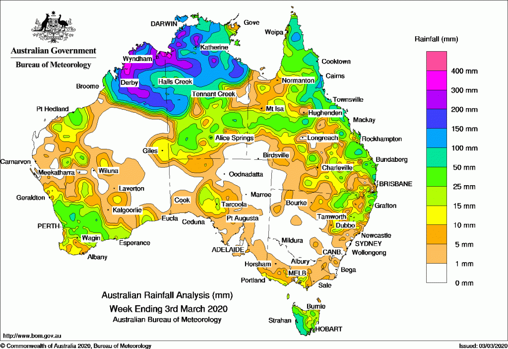
EX-TROPICAL cyclone Esther produced heavy falls in northern Australia, while thunderstorms brought moderate rainfall across parts of south-west and eastern Australia.
The highest weekly total was 366 mm at Mount Hart Station in the Kimberley in Western Australia.
Past seven days: In the first part of the week, ex-tropical cyclone Esther was situated on the monsoon trough over the top end of the Northern Territory. Large areas of convective cloud and thunderstorms generated moderate to locally heavy falls across northern Australia. A low pressure surface trough extended from ex-tropical cyclone Esther through western and central Queensland to north-eastern New South Wales, and another was situated along Queensland’s east coast. Thunderstorms and showers generating moderate falls developed about Queensland’s north tropical coast, the northern and central interior and the south-east coast.
A slow-moving trough of low pressure off the west coast of western Western Australia produced a series of thunderstorms developed in that state’s south-west. A strong cold front passed over Tasmania, and westerly winds ahead of the front produced areas of low cloud and isolated showers across the southeast coast of South Australia, coastal Victoria and parts of Tasmania.
The surface trough was persisted across northwest to southern inland Queensland into the middle of the week, with a moist and unstable air mass across most of eastern Queensland. Shower and thunderstorm activity and moderate falls affected much of the Queensland coast and northeastern New South Wales, with falls becoming light by mid-week.
Large areas of cloud persisted over northern Western Australia and the western Top End as ex-tropical cyclone Esther moved westward across the Kimberley before reversing track. Further moderate to locally heavy falls were recorded in the Kimberley and in most parts of the Northern Territory during the second half of the week.
At the end of the week, a cold front and pre-frontal trough tracked over southern and then southeast Australia, generating light falls along parts of the southern coastline, and moderate falls to Tasmania.
Rainfall totals in excess of 200 mm were recorded in across parts of the Kimberley in Western Australia and adjacent areas in the northwest and Top End in the Northern Territory. The highest weekly total was 366 mm at Mount Hart Station in the west Kimberley.
Rainfall totals in excess of 100 mm were recorded in most of the Kimberley, most of the Top End of the Northern Territory, and along the northeast to central coasts of Queensland.
Rainfall totals in excess of 50 mm were recorded in small parts of the South West Land Division and northern Western Australia, most of the northern half of the Northern Territory, across much of northern and east coast Queensland as well as isolated spots in the central west of that State, isolated locations in northeastern New South Wales, and western Tasmania.
Rainfall totals between 10 mm and 50 mm were recorded in much of western and northern Western Australia, most of the Northern Territory, except in the far southeast; most of Queensland except in the far southwest; northeastern New South Wales; far southern Victoria; an area north of Ceduna in Australia and most of Tasmania.
Little to no rainfall was recorded in areas in the far northwest coast and central interior parts of Western Australia, western and eastern South Australia, far southeastern parts of the Northern Territory, far southwest Queensland, western New South Wales and northern Victoria.
Highest weekly totals
New South Wales and Australian Capital Territory
90 mm Nimbin (Goolmangar Creek)
73 mm Nimbin Post Office
72 mm Mullumbimby (Fairview Farm)
Victoria
33 mm Ferny Creek
25 mm Mount Baw Baw, Monbulk (Spring Road)
Queensland
241 mm Caloundra Airport
183 mm Piccaninny Plains Station
152 mm Mulgrave Mill
Western Australia
366 mm Mount Hart Station
307 mm Kununurra Aero
279 mm Ellenbrae
South Australia
20 mm Parawa (Second Valley Forest A
18 mm Tarcoola Aero
16 mm Tarcoola (Mulgathing)
Tasmania
121 mm Mount Read
105 mm Lake Margaret Dam
85 mm Queenstown (South Queenstown)
Northern Territory
341 mm Labelle Downs
339 mm Buley Rockhole
302 mm Batchelor Airport
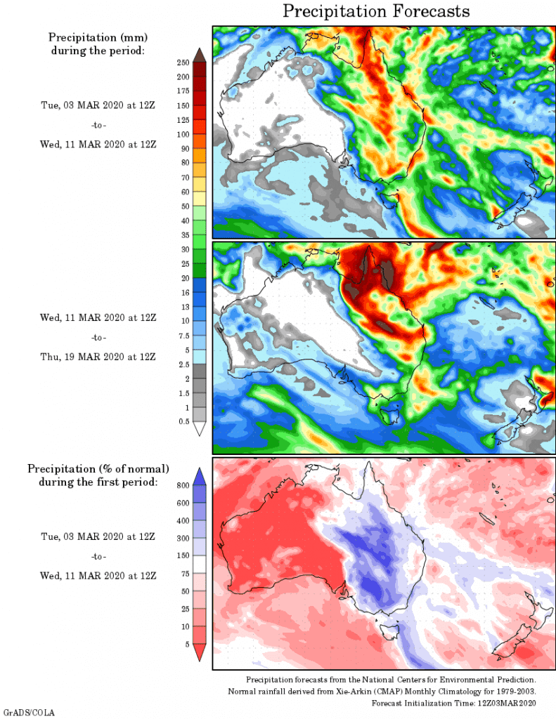
Rainfall outlook


HAVE YOUR SAY