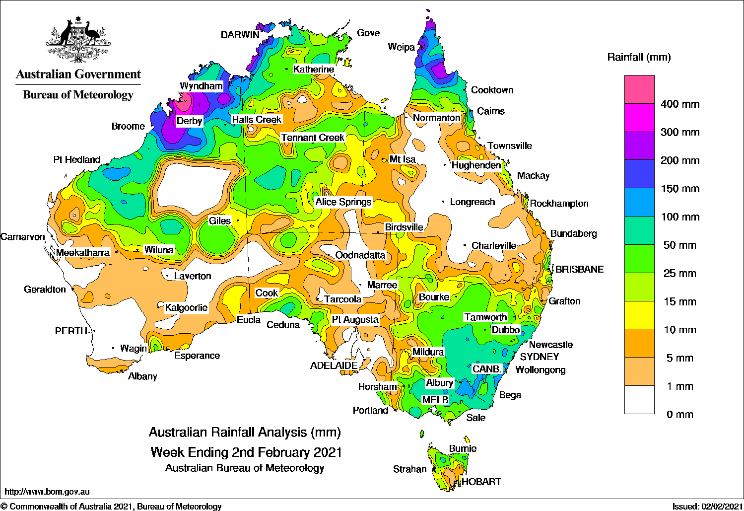
AN active monsoon trough and tropical lows produced heavy falls in the northern tropics. Cold fronts and surface troughs generated moderate falls across south-east Australia.
Past seven days: At the start of the week, an active monsoon trough across northern Australia and two embedded tropical lows were located in the eastern Gulf of Carpentaria and in the Kimberley in Western Australia. The systems generated heavy falls from the Kimberley, through the Top End in the Northern Territory, to the Cape York Peninsula.
A surface trough extended from southern parts of the Northern Territory, to the south-east mainland. Showers and thunderstorms produced moderate falls in eastern Victoria, southern and eastern New South Wales, southern parts of the Northern Territory and across the border in agricultural districts of South Australia.
A weak low pressure system and associated cold front developed in southern South Australia and moved east, with a pre-frontal trough stretching north-west through Central Australia to the tropical low in the Kimberley in Western Australia, drawing moist tropical air down to the south-east. Moderate falls were recorded in southern and eastern parts of South Australia, Victoria, northern Tasmania, and western and southern New South Wales.
Moderate to heavy falls continued across the northern tropics along the monsoon trough in the middle of the week. Showers and thunderstorms also developed over southern parts of the Northern Territory and through the Interior District in Western Australia, while onshore flow produced showers and mainly light falls along the east coast of New South Wales and parts of the Queensland east coast.
In the last part of the week, the tropical low over the Kimberley tracked south-west along the Pilbara coast, generating moderate falls in the western Kimberley, Pilbara and the Southern Interior districts. In the east, the tropical low developed into tropical cyclone Lucas in the Coral Sea, well off the north-east coast of Queensland on 31 January, and moved east-south-east outside the Australian tropical cyclone region.
At the end of the week, a trough and associated cloudband extended from central Australia and moved across south-east Australia while a weak cold front brushed Tasmania, producing moderate falls in central to eastern parts of New South Wales, eastern Victoria, and parts of eastern Tasmania. Storms and showers produced moderate falls over far south-east Queensland.
Rainfall totals in excess of 300 mm were recorded in the west Kimberley in Western Australia, including the highest weekly total of 476 mm at Mount Hart Station.
Rainfall totals in excess of 200 mm were reported across large parts of the Kimberley, the north-west Top End and the northern Cape York Peninsula.
Rainfall totals between 50 mm and 100 mm were reported in a large part of north-west Australian from the east Pilbara and Kimberley in Western Australia to the north-west Top End in the Northern Territory, the northern Cape York Peninsula, areas in central and south-east New South Wales, and in central and north-east Victoria.
Rainfall totals between 10 mm and 50 mm were recorded across most of central to northern Western Australia and in pockets along that state’s south coast; most of the Northern Territory; areas in the north, south and east of South Australia; western, southern and parts of east coast Queensland including the Cape York Peninsula; most of New South Wales; Victoria, and in northern and south-west Tasmania.
Highest weekly totals
New South Wales and Australian Capital Territory
150 mm Thredbo Village
147 mm Cabbage Tree Mountain
145 mm Thredbo AWS
Victoria
198 mm Falls Creek
135 mm Hunters Hill
129 mm Huon (Barkleys Camp)
Queensland
393 mm Lotus Bird Lodge
296 mm Southwell Station
259 mm Horn Island
Western Australia
476 mm Mount Hart Station
441 mm Myroodah
374 mm Debesa
South Australia
57 mm Lake George
54 mm Nundroo
44 mm Nullarbor
Tasmania
88 mm Gray (Dalmayne Rd)
67 mm Mount Barrow (South Barrow)
66 mm Mount Victoria (Una Plain)
Northern Territory
307 mm Charles Darwin University
Rainfall outlook
HAVE YOUR SAY