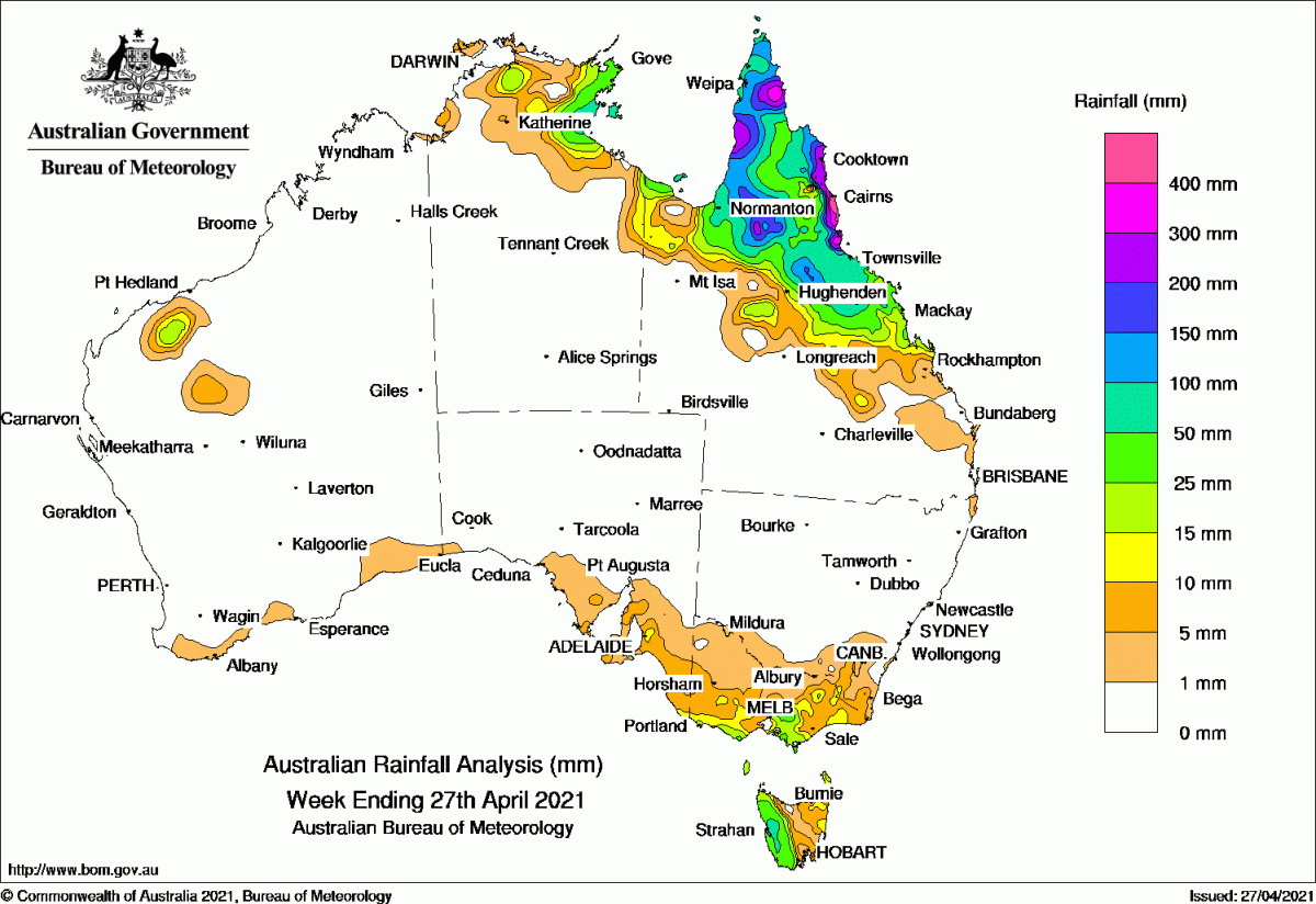
RAINFALL was observed across northern Queensland and the eastern Top End in the Northern Territory, most of Tasmania, southern and north-eastern Victoria, parts of south-eastern New South Wales, south-eastern South Australia, and isolated pockets in Western Australia’s southern coast and parts of the north-west.
Past seven days: At the start of the week, a lingering surface trough along the north-east coast of Queensland produced areas of heavy rainfall between Cairns and Ingham, and moderate falls across the southern Cape York Peninsula and northern interior of Queensland.
A cold front tracked across southern Australia, generating light falls on parts of the southern coast of Western Australia and South Australia. The cold front tracked over south-east Australia, and brought widespread showers extending into southern New South Wales, followed by a second weaker cold front later that day across western Tasmania and south-west Victoria.
In the west, a trough triggered showers about Western Australia’s De Grey, Fortescue, and East Gascoyne districts.
Another trough and low pressure system extended across the Gulf of Carpentaria and generated heavy falls about the Gulf Country and adjacent inland areas of Queensland’s northern interior during the first half of the week.
By the middle of the week, both troughs weakened and moved offshore, and rainfall eased to showers across tropical north Queensland, with some isolated moderate to locally heavy falls.
Mostly light falls continued across parts of Tasmania, Victoria, and south-east South Australia throughout the week, triggered by the passage of several weak cold fronts and a moist onshore flow.
Weekly rainfall totals in excess of 100 mm were observed across large areas of north tropical Queensland, with totals in excess of 300 mm for parts of the north tropical coast and in northern Cape York Peninsula. The highest weekly rainfall total was 684 mm at Mt Sophia in northern Queensland.
Rainfall totals between 50 mm and 100 mm were observed surrounding higher totals in tropical north Queensland, in the Arnhem and Roper–McArthur districts of the Northern Territory, and in western Tasmania.
Rainfall totals over 10 mm were observed in the De Grey and Fortescue districts of Western Australia, pockets of south-eastern South Australia, most of the southern half of Victoria, and north-east Tasmania.
Highest weekly totals
New South Wales and Australian Capital Territory
51mm Cathcart (Mount Darragh)
25mm Nimmitabel (Cottesloe)
22mm Byron Bay (Jacaranda Drive)
Victoria
62mm Wilsons Promontory Lighthouse
38mm Warburton (O’Shannassy Reservoir)
33mm Pound Creek Viewbank
Queensland
684mm Mt Sophia
538mm Tully Sugar Mill
528mm Cardwell Range
Western Australia
15mm Mount Florence
7mm Tangadee Walpole Forestry
South Australia
22mm Ashton
19mm Lenswood (Stringybark) Inglewood
Tasmania
128mm Mount Read
117mm Lake Margaret Dam
94mm Queenstown (South Queenstown)
Northern Territory
66mm Groote Eylandt Airport
37mm Ngukurr Airport
34mm Gove Airport
Rainfall outlook
HAVE YOUR SAY