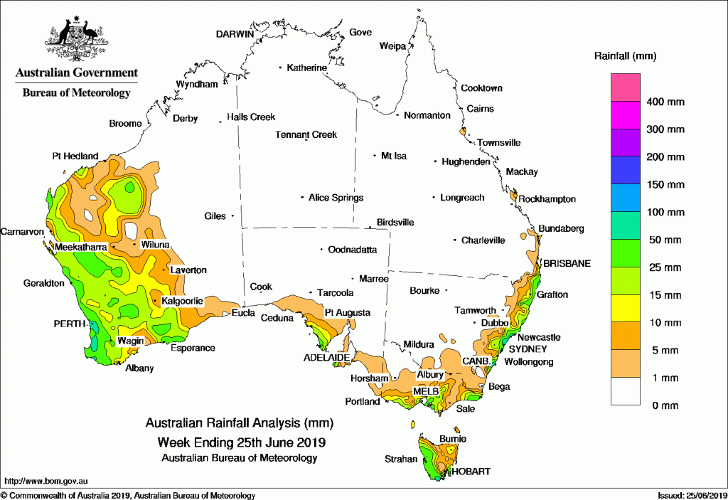
Past seven days: At the start of the week, a cold front and associated cloud band with embedded thunderstorms moved through southeast Australia, and produced moderate falls in western Tasmania and parts of southern Victoria. Widespread light falls extended across remaining parts of Tasmania, central to north-eastern Victoria, and south-eastern South Australia.
A weak low pressure system and associated trough moved north from the Great Australian Bight to the South Australia coast mid-week, and brought moderate falls to the Eyre Peninsula in South Australia. A trough brushed southern Tasmania and produced a few showers and moderate falls in the state’s south. In Western Australia, a surface trough and upper level disturbance brought showers and moderate falls to inland parts of the Pilbara and Gascoyne districts, with light falls extending into parts of the Goldfields District.
From mid-week onwards, a pair of cold fronts tracked across southwest Western Australia. The first strong cold front and pre-frontal trough produced an extensive rain band and brought moderate to locally heavy falls to much of the south-west coast of Western Australia, and as the system moved eastwards, produced further moderate rainfall totals across much of the South West Land Division and Gascoyne District. The second cold front moved quickly across the far south-west of the State, and produced further falls to these regions.
A high pressure system over south-east Australia directed moist, south-easterly winds onto the east coast of New South Wales. Thunderstorms and showers developed along the east coast of New South Wales and in far south-east Queensland in the last days of the week, with locally moderate to heavy falls along the Illawarra coast in New South Wales.
Rainfall totals in excess of 100 mm were recorded in isolated parts of the Illawarra coast of New South Wales. The highest weekly total was 146 mm at Jervis Bay in New South Wales.
Rainfall totals in excess of 50 mm were recorded along the south-west coast of Western Australia, parts of western Tasmania, and in pockets of the central and south-east coasts of New South Wales.
Rainfall totals between 10 mm and 50 mm were recorded across large parts of the west of Western Australia, about the Eyre Peninsula and Kangaroo Island in South Australia, southern and eastern Victoria, western and southern Tasmania, far southeast Queensland and much of the east coast of New South Wales.
Little or no rainfall was recorded in remaining areas of Western Australia, the Northern Territory, Queensland excluding the far south-east coast, most of South Australia away from the south coast, central to western New South Wales, and north-western Victoria.
Highest weekly totals
New South Wales and Australian Capital Territory
146 mm Jervis Bay
109 mm Jervis Bay (Point Perpendicular),Wyong (Mount Elliot)
Victoria
51 mm Cape Schanck
50 mm Rosebud (Country Club)
49 mm Point Hicks (Lighthouse)
Queensland
43 mm Cape Moreton Lighthouse
32 mm Fraser Island Eurong
26 mm CoolangattaSpringbrook Road
Western Australia
82 mm Bungendore
80 mm Burekup
77 mm Karragullen North
South Australia
48 mm Cape Borda
32 mm Mount Hope (Fairview)
29 mm Coffin Bay (Point Avoid)
Tasmania
65 mm Port Arthur (Stewarts Bay)
59 mm Zeehan
58 mm Scotts Peak Dam
Northern Territory
1 mm Conways
Rainfall outlook:
![]()
HAVE YOUR SAY