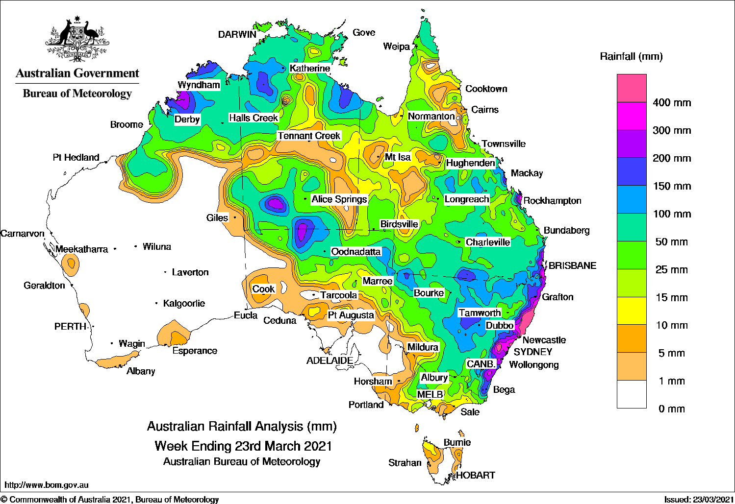
WIDESPREAD moderate rainfall in the northern tropics and eastern mainland, while a slow-moving coastal trough and a developing low pressure system brought persistent heavy rainfall along the Hunter and Mid North Coast in New South Wales.
Past seven days: At the start of the week, a surface trough across the inland north and east of the country produced moderate rainfall in the west Kimberley, the northern Top End and the Carpentaria district in the Northern Territory, the Gulf Country, Cape York Peninsula, central and southern Queensland, and inland northern parts of New South Wales. An isolated, extremely heavy daily rainfall total of 550 mm was recorded at Byfield Childs Road in the Capricornia District in Queensland. A high pressure system over the Tasman Sea directed easterly winds with showers along the New South Wales coast.
A tropical low developed to the west of the Kimberley on the 18th in the vicinity of a trough extending from the northern Gulf of Carpentaria to the Indian Ocean. Showers and thunderstorms with moderate falls were reported in the eastern Pilbara and the Kimberley in Western Australia, the Top End in the Northern Territory, and the far north of Queensland.
In the meantime, a trough developed near the north coast of New South Wales and produced moderate rainfall along the state’s coast, with locally heavier falls over 100 mm recorded in the Mid North Coast District. The trough over inland Queensland and western New South Wales brought showers to the north-west to central coast of Queensland, and northern and central New South Wales.
During the middle of the week, the tropical low remained off the north-west of Western Australia, while the coastal trough in New South Wales deepened and expanded north along the south-east Queensland coast and down to the south coast of New South Wales. Moderate rainfall continued in the Pilbara and Kimberley, and the Top End in the Northern Territory, and also along the east coast of Australia. Heavy daily falls over 100 mm were recorded over several days in the Mid North Coast in New South Wales.
In the last part of the week, the tropical low weakened and moved south-east across the west Kimberley coast. A trough and associated cloudband extended from the low to southern parts of the Northern Territory, south-western Queensland, and the country’s south-east. A low pressure system developed over inland northern New South Wales and moved across the state’s central districts towards the east coast, while the coastal trough remained near-stationary. Multiple flood warnings were issued for coastal rivers from the mid-north coast to south of Sydney, with major flooding occurring along the Hawkesbury Nepean River Valley (HNV) at North Richmond. Widespread moderate rainfall was recorded in the southern Northern Territory, northern South Australia, central to southern and south-east Queensland, much of New South Wales, and far north-east and central Victoria. Locally heavier falls over 100 mm was recorded in northern South Australia, southern Queensland and northern New South Wales.
Rainfall totals in excess of 400 mm were reported along the coastal areas and Central Tablelands in New South Wales, and a number of locations in Queensland’s central and south-east coast districts. Locations in the Hunter and Mid North Coast districts in New South Wales received over 600 mm of rainfall, including the highest weekly total of 991 mm at Bellwood in the Mid North Coast, which has exceeded the long-term autumn rainfall average less than one month into the season.
Rainfall totals between 200 mm and 400 mm were recorded in areas along the east coast, central and inland southern Queensland, and in the north and along eastern New South Wales. Small areas in the west Kimberley in Western Australia and north-west Top End in the Northern Territory also recorded similar totals.
Rainfall totals between 50 mm and 200 mm were recorded across the Kimberley and eastern Pilbara; in the northern half and south-western parts of the Northern Territory; in the far north of the Cape York Peninsula, and areas across eastern and southern Queensland; most of the New South Wales except the south-west; northern parts of the South Australia, and northern Victoria.
Rainfall totals between 10 mm and 50 mm were recorded across most of the Northern Territory, Queensland, the north-eastern half of South Australia, the eastern half of Victoria, and north-western Tasmania.
Highest weekly totals
New South Wales and Australian Capital Territory
922 mm Bellwood (Nambucca Heads)
889 mm Comboyne (Public School)
800 mm Yarras (Mount Seaview)
Victoria
52 mm Tongala
48 mm Kyabram
47 mm Grampians (Mount William)Bendigo AirportMaryborough
Queensland
878 mm Byfield Childs Road
393 mm Samuel Hill Aero
318 mm Mt Tamborine Fern St
Western Australia
226 mm Windjana Gorge
222 mm Truscott
219 mm Cygnet Bay
South Australia
128 mm Mount Dare
100 mm Tieyon
65 mm Todmorden
Tasmania
10 mm Gray (Dalmayne Rd)
8 mm Sheffield School Farm
4 mm Upper Esk (South Esk River), Flinders Island AirportMemana (Babel Farm)
Northern Territory
208 mm Bradshaw – Angallari Valley
192 mm Merlin Mine
170 mm Sunshine Bore
Rainfall outlook
HAVE YOUR SAY