A SERIES of low pressure systems and cold fronts that moved across the southern half of Australia through the week brought moderate falls to vast areas of the southern states.
The rain in the south-west of Western Australia continued a wet spell in the region that has extended over two weeks.
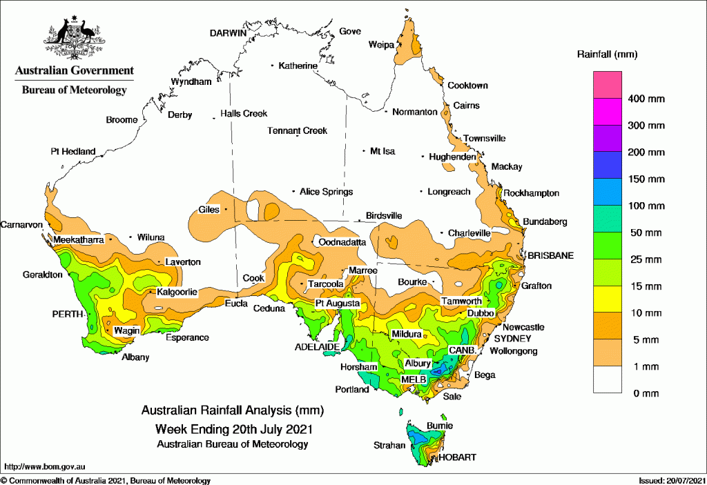
Past seven days: For the week to 20 July 2021 rainfall was recorded in most of the South West Land Division (SWLD), the south-east Gascoyne and Central West districts, and adjacent parts of Goldfields in Western Australia; central and southern South Australia and most of Victoria away from the far east. Rainfall was also recorded in southern, central and eastern parts of New South Wales away from the coast; most of Tasmania away from the south-east; and the inland south-east and coastal areas of the Wide Bay and Burnett District in Queensland.
At the start of the week, a trough extended across South Australia and south-western parts of the Northern Territory, associated with a slow-moving low pressure system in the Great Australian Bight. Rainfall was mostly light over the south-west of the Northern Territory, much of South Australia and Victoria, south-west New South Wales, and northern and western Tasmania. Moderate falls were recorded in the North West Pastoral and Flinders districts in South Australia and north-west Victoria.
In the west, a weak cold front and a trough, also connected to the low in the Bight, tracked across the south-west of Western Australia, resulting in a continuation of the wet spell in the region (now extending to two weeks).
As the trough tracked through south-east and eastern Australia, it was followed by several fast-moving troughs passing across the south-east of the country. Moderate rainfall was recorded in coastal areas in South Australia; northern Tasmania; areas in south-west, central and north-east Victoria; the inland south-east and north-east of New South Wales; and along the southern border of Queensland.
During the middle part of the week, a strong cold front moved across southern South Australia and the south-east states, while the weakening low pressure system tracked across Tasmania. Widespread moderate rainfall was recorded in south-eastern South Australia, including the Flinders, Mid North, Mount Lofty Ranges and South East districts; the west, north-east and west Gippsland in Victoria, inland eastern New South Wales from the Snowy Mountains to the Central Tablelands districts; and in the north and west of Tasmania. Light rainfall was reported in the south coastal areas of Western Australia, the west coast of South Australia, central Victoria, south-west New South Wales, and south-east Queensland.
In the last part of the week, another strong cold front moved from the Bight to southern South Australia, Victoria and Tasmania, and produced further moderate falls in southern South Australia, in the far south-west of Victoria, and in western Tasmania.
In the west, a cut-off low developed off the west coast of Western Australia, and cloud extended from the north-west over the west and south of the state. Moderate rainfall was recorded in the Central West District, northern parts of the Central Wheat Belt, and adjacent Goldfields in Western Australia. The state’s south-west recorded mainly light rainfall.
Rainfall totals in excess of 100 mm were reported in spots in the Yorke Peninsula, and Mount Lofty Ranges in South Australia; the North East District, and an elevated spot in the South West District in Victoria; and spots in the Snowy Mountains and Northern Tablelands in New South Wales. Weekly totals over 100 mm were also recorded in the north-west of Tasmania, and Mount Read had the highest total of 171.4 mm.
Rainfall totals in excess of 50 mm were reported in small areas in the south-west of Western Australia; southern South Australia including Kangaroo Island, Adelaide Metropolitan, Mount Lofty Ranges, and the south-east of the state; and the far south-west and northern-east of Victoria. Similar totals were recorded across inland south-east New South Wales and Australian Capital Territory, and most of the north and west of Tasmania.
Rainfall totals between 10 mm and 50 mm were recorded in the south-east Gascoyne, Central West districts, most of the SWLD, and adjacent Goldfields areas in Western Australia; and in the North West Pastoral, West Coast and Flinders districts in South Australia and the state’s south from the Eyre Peninsula eastward. Similar totals were recorded across most of Victoria away from the far east, most of south, central and eastern New South Wales away from the coast, most of Tasmania away from the south-east; and in the south-east inland and coastal parts of the Wide Bay and Burnett District in Queensland.
Highest weekly totals list and map
New South Wales and Australian Capital Territory
136 mm Perisher Valley Aws
107 mm Glen Innes Airport Aws
93 mm Thredbo Village
Victoria
126 mm Hunters Hill
125 mm Grampians (Mount William)
119 mm Whitlands (Burder’S Lane)
Queensland
27 mm Leslie Dam
25 mm Connolly Dam Alert
24 mm Multiple locations
Western Australia
75 mm Walpole Forestry
67 mm Bickley
64 mm North Walpole
South Australia
124 mm Piccadilly (Woodhouse)
119 mm Lenswood, Minlaton Aero
Tasmania
171 mm Mount Read
124 mm Jackeys Marsh
119 mm Quamby Bluff
Northern Territory
8 mm Curtin Springs
1.6 mm Yulara Airport
1.1 mm Uluru Rangers


HAVE YOUR SAY