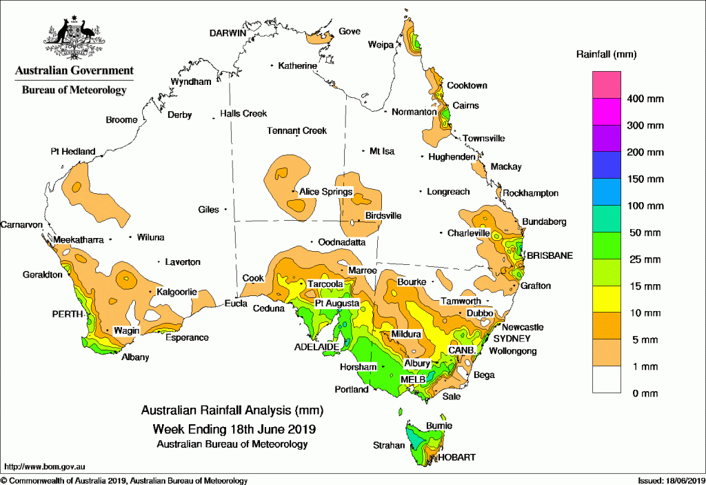
Past seven days: An extensive rain band associated with the passage of a sequence of cold fronts and pre-frontal troughs crossed southern Australia during the first half of the week, followed by westerly winds with embedded fronts during the rest of the week. Moderate falls were produced over agricultural districts of South Australia, much of Victoria and Tasmania, and parts of southern New South Wales and the Western Slopes at the start of the week, with light falls across much of the remainder of Victoria and western Tasmania continuing into mid-week.
Light falls were recorded throughout much of the week along the west coast and south-west of Western Australia in a persistent westerly air stream.
Onshore flow across the east coast of northern Queensland led to periods of light to locally moderate falls throughout the week.
Scattered light falls continued over coastal southern Australia during the last part of the week, while a low pressure centre developing on a surface trough offshore of the east coast contributed to moderate to locally heavy falls in the Illawarra in New South Wales and across south-east Queensland.
Rainfall totals in excess of 50 mm were recorded in west coast Tasmania, elevated parts of Victoria’s Alpine region and Central Highlands, parts of South Australia’s Mount Lofty Ranges, and a small area of New South Wales’ Central Coast. Higher weekly totals approaching or exceeding 100 mm were observed in a number of individual locations, including in the Sydney Metropolitan region, the peaks of the Victorian Alps, about Mount Lofty, in West Coast Tasmania, and in Queensland’s Moreton South Coast region. The highest weekly total was 116 mm at Mount Read in West Coast Tasmania.
Rainfall totals between 10 mm and 50 mm were recorded along the west coast and south-west of Western Australia and part of the south coast around Esperance; across agricultural districts of South Australia and as far west as Ceduna; across most of Victoria except East Gippsland and parts of the northern border; most of Tasmania except parts of the southeast and east coast; about the South West Slopes and eastern Riverina in New South Wales, extending into parts of central New South Wales and north of the ACT to take in the coastal margin of the Hunter, Metropolitan, and Illawarra. Weekly totals between 10 mm and 50 mm were also observed in south-east Queensland and the adjacent north-eastern tip of New South Wales, and some parts of the east coast of Cape York Peninsula and the North Tropical Coast.
Some pockets of the southern Northern Territory and south-east Queensland received falls in excess of 5 mm for the week.
Little or no rainfall was recorded in most of the Northern Territory, most of Western Australia away from the west and south coast, Queensland away from the south-east and east coast, northern and parts of far south-eastern New South Wales, and northern and western South Australia.
Highest weekly totals
New South Wales and Australian Capital Territory
109 mm Randwick (Randwick St)
107 mm Dover Heights (Portland St)
97 mm Rose Bay (Royal Sydney Golf Club)
Victoria
102 mm Falls Creek (Rocky Valley)
101 mm Mount Buller
85 mm Falls Creek
Queensland
92 mm Caloundra Airport
85 mm Landsborough
56 mm Cowley Beach (Defence)
Western Australia
49 mm Cowaramup
47 mm Pemberton
44 mm Lancelin
South Australia
100 mm Heathfield Works Depot
95 mm Aldgate
90 mm Mount Lofty
Tasmania
116 mm Mount Read
91 mm Lake Margaret Dam
86 mm Queenstown (South Queenstown)
Northern Territory
5 mm MaryvaleAlcan Minesite
4 mm Territory Grape Farm


HAVE YOUR SAY