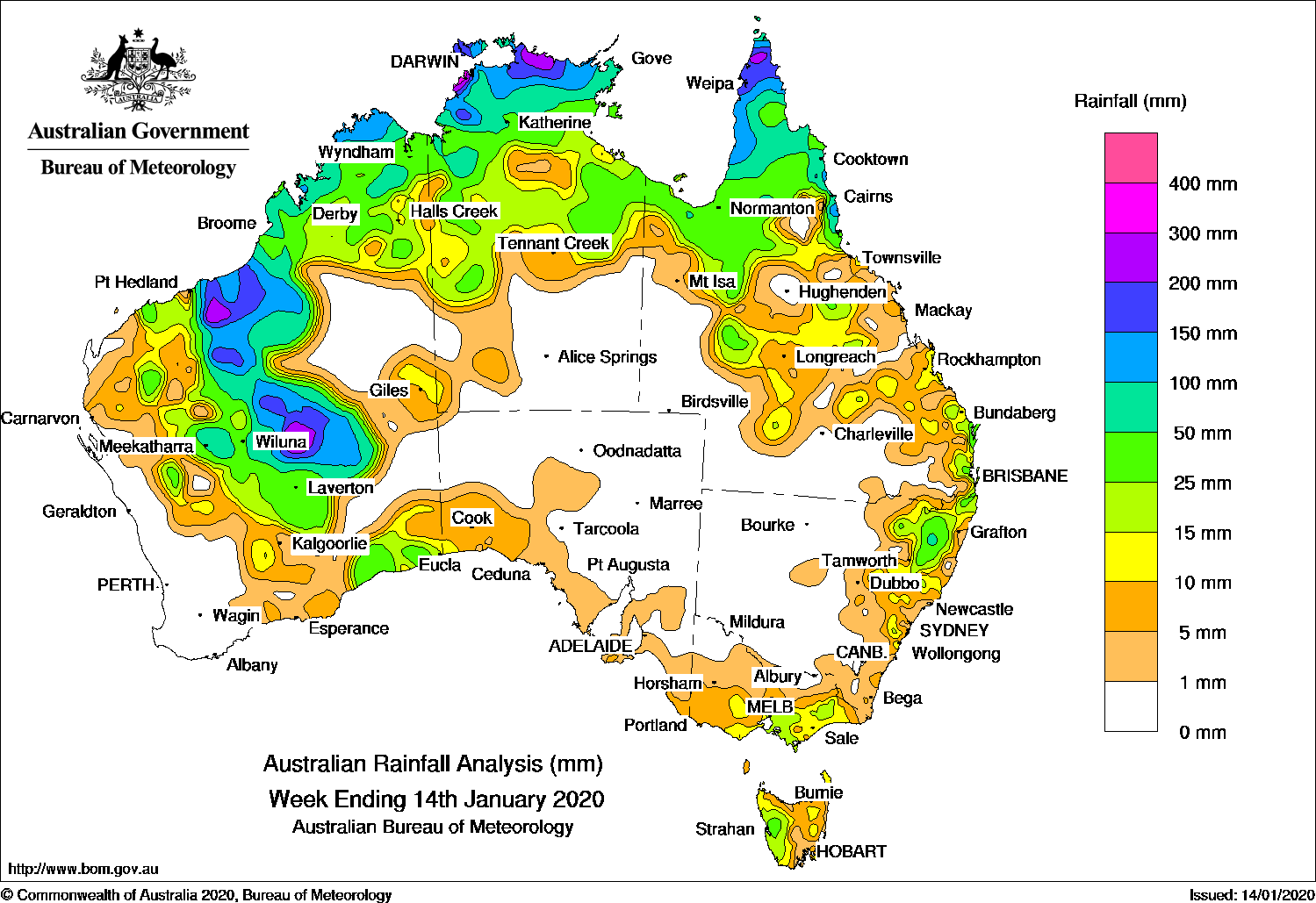
EX-TROPICAL cyclone Blake has brought heavy falls to the Pilbara and interior of Western Australia, while tropical cyclone Claudia produced moderate to heavy rainfall in the Top End and north Kimberley coast.
Past seven days: In the first half of the week, after crossing the south-west Kimberley coast, tropical cyclone Blake soon weakened and moved through the inland east Pilbara as an ex-tropical cyclone, and brought moderate to locally heavy falls to the west Kimberley and east Pilbara. As ex-tropical cyclone Blake moved south into the western Interior of Western Australia then dissipated, the system produced moderate to heavy falls over parts of the Pilbara, interior, Gascoyne, Goldfields and south-east districts of Western Australia.
To the north-east of the Northern Territory, a slow-moving tropical low pressure system embedded on the monsoon trough moved west-south-west and intensified over the coastal Top End of the Northern Territory. Moderate to heavy falls were recorded over the Top End in the Northern Territory and the north Kimberly coast in Western Australia. Dum In Mirrie Airstrip, located at a northwest offshore island in the northern Territory, recorded the Territory’s highest daily rainfall on record at 562 mm on 11 January. The tropical low moved westwards, intensified, and was named tropical cyclone Claudia just before midnight on 12 January 2020, while remaining offshore, north of the Kimberley coast in Western Australia. Showers and thunderstorms with moderate to locally heavy falls were also reported across the Cape York Peninsula and the north tropical coast of Queensland from moist onshore flow.
From the middle of the week, a mid-level cloudband extended from the remnants of ex-tropical cyclone Blake and across much of the Interior of Western Australia, South Australia, Victoria and Tasmania, associated with the passage of a surface trough and cold front. Moderate falls were reported in parts of southern Victoria and western Tasmania, and widespread light falls were recorded in southern South Australia, much of the southern half of Victoria and eastern Tasmania. The trough moved east through New South Wales, bringing some light to moderate rainfall to the northeast of that State. Another broad trough through inland Queensland triggered thunderstorms and showers, with moderate falls recorded in some areas in a line from the northwest to southeast of Queensland.
A weak low pressure system in the inland Pilbara in Western Australia produced moderate rainfall in that area, and in the eastern Gascoyne. Though Claudia later intensified into a severe tropical cyclone off the northwest Pilbara coast, it brought mainly light falls along the northwest Western Australia coast.
Rainfall totals in excess of 150 mm were recorded in areas from the south-west Kimberley coast, and east Pilbara to western parts of the southern interior district in Western Australia; also across the coastal Top End and the far north of Cape York Peninsula. The highest weekly total was 630 mm at Dum In Mirrie Airstrip in the Northern Territory.
Rainfall totals in excess of 100 mm were recorded in the northern Kimberley, along the east Pilbara and down to central Western Australia; along the coastal Top End and Darwin – Daly District in the Northern Territory, and the far northern Cape York Peninsula.
Rainfall totals in excess of 50 mm were recorded across much of northern Australia coast from Broome in Western Australia to Innisfail along the north tropical coast of Queensland. Similar totals were recorded across much of the eastern Pilbara and central Western Australia.
Rainfall totals between 10 mm and 50 mm were recorded in northern and central Western Australia, as well as the State’s south-east; areas south of the Top End in the Northern Territory; in parts of northern and eastern Queensland; areas of southern Victoria, and western Tasmania; north-eastern parts, the Central Tablelands and Illawarra districts in New South Wales
Little or no rainfall was reported near the west coast of Western Australia, most of South Australia away from the southern coast, far northern Victoria; central to western New South Wales, the southern half of the Northern Territory, and western Queensland.
Highest weekly totals
New South Wales and Australian Capital Territory
88 mm Guyra (Gowan Brae)
80 mm Guyra (Box Point)
58 mm Deepwater Post Office
Victoria
27 mm Ferny Creek
25 mm Main Ridge, Scoresby Research Institute
Queensland
269 mm Lockhart River Airport
216 mm Southwell Station
197 mm Weipa Aero
Western Australia
244 mm Marble Bar
226 mm Prenti Downs
197 mm Wongawol
South Australia
9 mm Mount Gambier Aero
8 mm Cook
7 mm Multiple locations
Tasmania
40 mm Mount Read
35 mm Lake Margaret Dam
33 mm Lake Margaret Power Station
Northern Territory
630 mm Dum In Mirrie Airstrip
546 mm Wagait Beach
270 mm Warruwi Airport
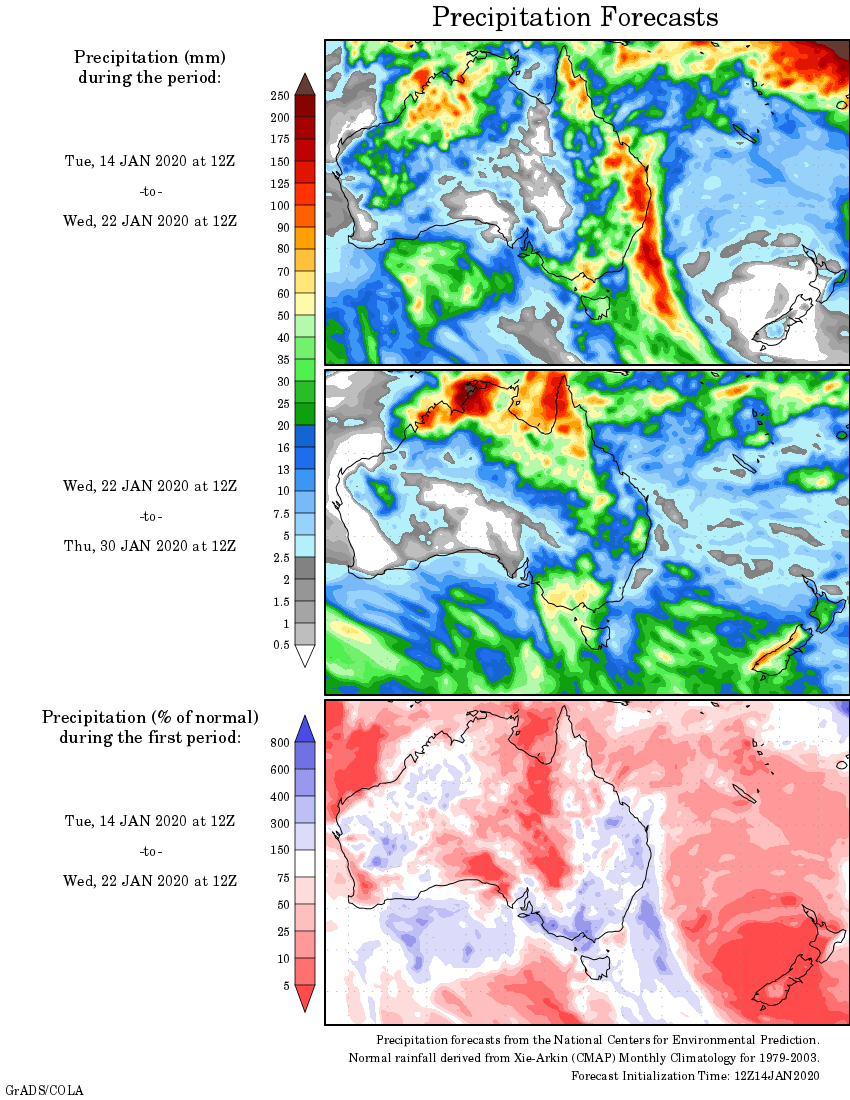
Rainfall outlook


My first conjecture is about whether HAARP (High Frequency Active Auroral Research Program) is to blame for this weather destruction. Have our fantasised “friends'” ruined the weather perhaps forever?
Is there any point in saying anything? As the ice melts, we are still hearing ‘happened before …10,000 years ago….20 million years ago’…evasion. The point is, what are we doing now to save us from our gross overpopulation and what is happening irrespective of the ’cause’?
We have one ‘would-be emperor’ recently featured on Landline who has bored enough water to increase stock from 8000 to 40,000 and is still after more, a Central West dairy (for one) which uses so much water its neighbours bores are failing…and in utter ignorance as is so common is irrigating in daylight presumably to reduce burning. Change in agriculture is of the essence but…let’s just whistle Dixie.
This is the ‘all about me time. What plans are there for the reduction of water use?…Do you have any idea how long it takes to refill aquifers and the artesian basin? No, well good idea to find out and start regulating I’d say,.wouldn’t you?