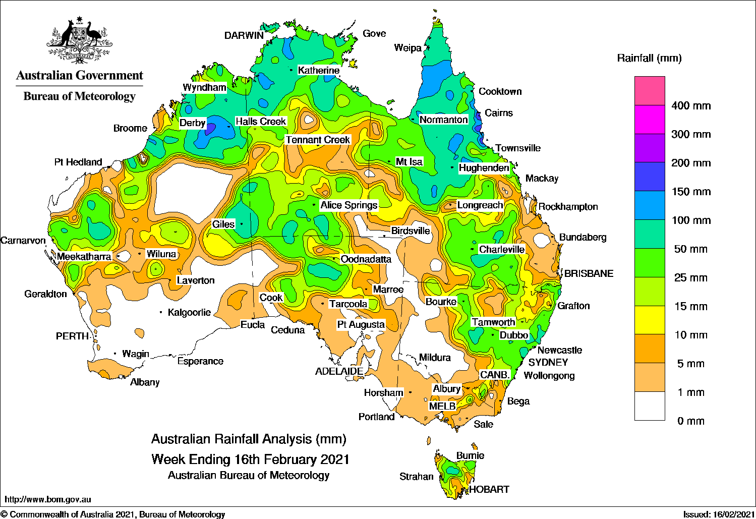
TROPICAL lows and surface troughs brought moderate falls to northern Australia, while a cold front and pre-frontal trough generated moderate falls in parts of Central Australia and south-east Australia.
Past seven days: At the beginning of the week, surface troughs extended across northern Australia, with an embedded low pressure system over the east Kimberley in Western Australia. Showers and thunderstorms generated moderate falls over the Kimberley, in the north-west and central parts of the Northern Territory, and the Cape York Peninsula and north tropical coast of Queensland. In the south, a cold front brushed the south-west coast of Western Australia, with light falls recorded.
The low pressure system in the Kimberley moved across inland north-west Western Australia to the west Pilbara, with a trough extending eastwards to the southern Northern Territory and South Australia. In the east, a high pressure ridge directed onshore flow along the Australian east coast. Widespread thunderstorms and showers developed from the Cape York Peninsula and north tropical coast, and through central to southern inland Queensland; also about the Gulf Country. Isolated thunderstorms generated moderate falls in the Interior District of Western Australia and agricultural districts in South Australia. Light falls were reported across most of Victoria and moderate falls were recorded in northern Tasmania.
In the middle of the week, the cold front tracked across south-eastern South Australia, Victoria and Tasmania, while the pre-frontal trough moved east through central and south-eastern parts of the country, and southern Queensland. An extensive cloudband stretched from the Gascoyne in Western Australia to the Tasman Sea. Moderate falls were recorded across the southern half of the Northern Territory, northern parts of South Australia, western and southern inland Queensland, and from north-west to south-east New South Wales. Thunderstorm activity continued across the Top End, Gulf Country and the Cape York Peninsula associated with the surface trough across northern Australia.
In the last part of the week, a high pressure system moved into the southern Tasman Sea with moist onshore flow producing moderate falls along the New South Wales coast. Thunderstorms and showers were mostly confined to northern Australia, with moderate falls reported in the Kimberley and interior of Western Australia, parts of the Top End and most of the northern half of Queensland.
Rainfall totals in excess of 150 mm were reported in southern parts of the Kimberley and areas of the north tropical coast of Queensland, including the highest weekly total of 259 mm at Ingham Composite.
Rainfall totals in excess of 100 mm were reported in the inland southern Kimberley in Western Australia, spots in the Top End of the Northern Territory, parts of the Cape York Peninsula and north tropical coast of Queensland.
Rainfall totals between 50 mm and 100 mm were recorded in the Gascoyne, Southern Interior and Kimberley districts in Western Australia; spots in northern South Australia, in the Top End and southern parts of the Northern Territory; northern and southern inland parts of Queensland; in western and central coast areas of New South Wales, and in north-west Tasmania.
Rainfall totals between 10 mm and 50 mm were recorded across large parts of the northern two-thirds of Western Australia; most of the Northern Territory, northern and central parts of South Australia; central to eastern New South Wales excluding the far south-east coast, and in the Snowy Mountains; north-eastern Victoria, and most of Tasmania.
Weekly rainfall totals map
Highest weekly totals
New South Wales and Australian Capital Territory
139 mm Careys Peak (Barrington Tops)
104 mm Wollombi (St Johns Church)
103 mm Barrington Tops (Mount Barring
Victoria
34 mm Falls Creek
29 mm Mount Hotham, Falls Creek (Rocky Valley)
Queensland
259 mm Ingham Composite
254 mm Bambaroo
248 mm Victoria Sugar Mill
Western Australia
217 mm Mount Krauss
151 mm Mount Winifred
147 mm Ruby Plains
South Australia
142 mm Ernabella (Pukatja)
60 mm Mount Barry Station
45 mm Coober Pedy Airport
Tasmania
73 mm Quamby Bluff, Jackeys Marsh
68 mm Meander (Meander River)
Northern Territory
160 mm Bulman
158 mm Bradshaw – Angallari Valley (D
130 mm Mount Bundey North (Defence)
Rainfall outlook
HAVE YOUR SAY