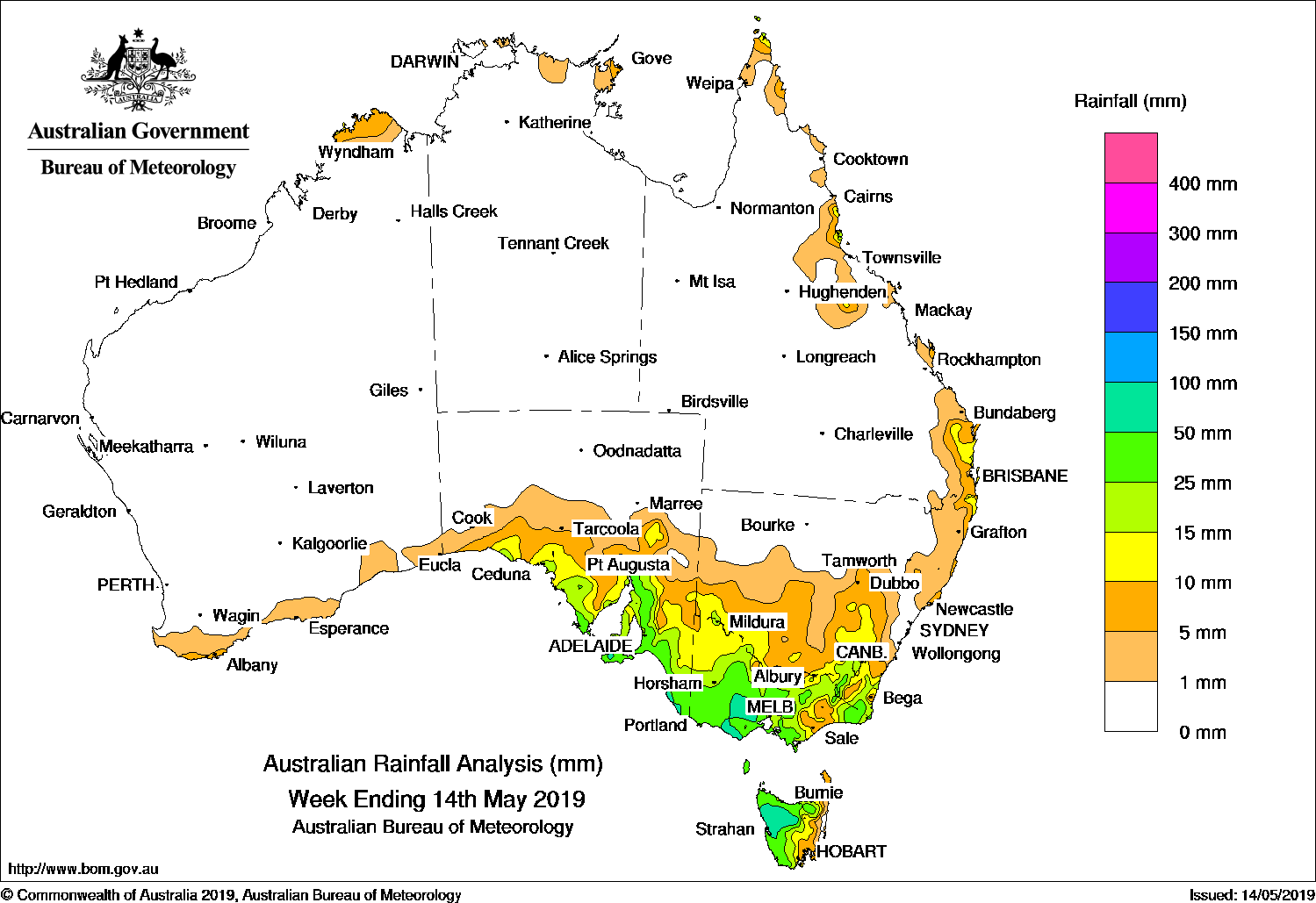
A COLD front brought light to moderate falls to southern parts of South Australia at the start of the week, while a vigorous cold front and a complex low pressure system mid-week produced moderate to locally heavy falls to parts of south-eastern Australia, including Tasmania.
Past seven days: At the start of the week, a thick cloud band associated with a cold front moved through southeast Australia, producing moderate falls in south-eastern South Australia, south-western and central Victoria, and light falls in northern Tasmania, northeastern Victoria, and into elevated areas of south-eastern New South Wales. Further west, another cold front extended through the Great Australian Bight, and moved eastwards towards south-east Australia. As the front extended into south-eastern parts of South Australia to Tasmania, a band of mid-level cloud with isolated thunderstorms brought moderate falls along the coast of South Australia and to the south-eastern quarter of that State.
The vigorous cold front continued eastwards in the middle of the week. A cold south-west to westerly flow, and embedded thunderstorms, produced moderate to locally heavy falls from western to central Victoria, southwestern New South Wales and across northern Tasmania. A complex area of low pressure associated with the cold front developed over northern Victoria, and triggered further light to moderate falls in central and eastern Victoria and south-eastern New South Wales. Widespread light falls were reported over much of the southern half of New South Wales and western Tasmania. As the systems moved offshore, the tip of the cold front and a surface trough tracked across south-eastern Queensland and north-eastern New South Wales, and brought showers and mainly light falls to the area.
During the week, moist onshore flow brought showers and light falls to parts of the Kimberley in Western Australia, the Top End in the Northern Territory, and coastal parts of northern Queensland. Two tropical cyclones were active in the Australian region during the week, but had no impact on the mainland. Tropical cyclone Lili developed to the north of the Top End in the Northern Territory and tropical cyclone Ann formed in the Coral Sea at the end of the week, and tracked eastwards towards the coast as a category 1 system.
Rainfall totals in excess of 100 mm were recorded in small areas of Tasmania, including the highest weekly total of 134 mm at Mount Read.
Rainfall totals in excess of 50 mm were recorded in parts of Kangaroo Island and the far southeast of South Australia, southern central, central west, and Otways in Victoria, and in the northwest of Tasmania.
Rainfall totals between 10 mm and 50 mm were recorded in southern South Australia, nearly all the remainder of Victoria, the remainder of Tasmania except the east coast, areas of southern and south-eastern New South Wales, the far north-east of New South Wales and south-eastern Queensland, and small areas of the north tropical Queensland coast.
Little or no rainfall was recorded in most of Western Australia, the Northern Territory, the northern half of South Australia, most of the northern half and parts of the east coast of New South Wales, and most of Queensland except isolated parts of the east coast of that State.
Highest weekly totals
New South Wales and Australian Capital Territory
34 mm Nimmitabel (Cottesloe)
32 mm Newcastle University
30 mm Nimmitabel Wastewater TreatmenBombala (Therry Street)
Victoria
87 mm Meredith (Darra)
86 mm Meredith
82 mm Pyrenees (Ben Nevis)
Queensland
25 mm Daintree Village
23 mm Macknade Sugar Mill
22 mm Innisfail
Western Australia
10 mm Troughton Island
8 mm Truscott, Cherry Tree
South Australia
74 mm Ashton
63 mm Mount Compass
58 mm Aldgate
Tasmania
134 mm Mount Read
95 mm Lake Margaret Power Station
89 mm Mount Barrow (South Barrow)
Northern Territory
12 mm Gove Airport
4 mm Maningrida Airport
2 mm Black Point
Rainfall outlook:
HAVE YOUR SAY