A SERIES of cold fronts moved across southern Australia through the week, bringing moderate falls to southern Western Australia and lighter falls to the southern states.
In the middle of the week, a trough extended across inland Queensland to northern New South Wales, producing moderate rainfall to southern parts of Queensland and north-eastern NSW.
Rain cleared from most of eastern Australia by the end of the week.
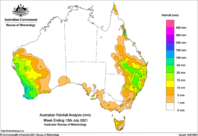
Past seven days: For the week to 13 July 2021, rainfall was recorded in most of the South West Land Division (SWLD), the Gascoyne and Central West districts in Western Australia; Kangaroo Island and the Lower Eyre Peninsula coast in South Australia; small areas in the west and north-east of Victoria; areas in the Western and Central Plateau districts in Tasmania; the north-west and central coast in New South Wales; and southern parts of Queensland away from the south-west, the state’s North Tropical Coast and far northeast of Cape York Peninsula.
At the start of the week, a cold front moved across south-west and southern Western Australia, and an associated low pressure system located in the south of Western Australia tracked across the Great Australian Bight. Moderate rainfall was recorded in the south-west, and mostly light rainfall was recorded in the south coast of Western Australia.
In the east, moist onshore flow associated with a high pressure ridge to produce thunderstorms and showers over the Queensland North Tropical Coast.
At the middle of the week, a trough extended across inland Queensland to northern New South Wales, and produced moderate rainfall to southern parts of Queensland and north-eastern New South Wales. Light rainfall was recorded in the central regions of both states. A weak low pressure system formed near the north-east coast of New South Wales and soon developed to a complex low in the western Tasman Sea, with onshore flow producing moderate rainfall along the central coast in New South Wales, with light falls in eastern parts of the state and far south-east of Queensland.
In the west, a strong cold front and a pre-frontal trough moved through the west and south of Western Australia, with the associated low pressure system was located off the state’s south-west coast. Widespread moderate rainfall was recorded in most of the SWLD, with heavier daily totals of 30 mm to 60 mm recorded in and around the Perth Metropolitan area, and south-west coast. Flash flooding was reported around Perth suburbs.
At the end of the week, rainfall was clearing from most of eastern Australia, while the weakening low pressure system in the eastern Great Australian Bight directed westerly flow with mostly light falls over south-western South Australia, southern Victoria and northern and western Tasmania.
In the west, another strong cold front across the south-west and southern parts of Western Australia, and a pre-frontal trough and associated cloudband extending from the north-west. A strong low pressure system, connected to the front, tracked across the south-west of the state. Widespread moderate rainfall totals were recorded in the Gascoyne, along the west coast and far south-west of Western Australia. with light falls in the northern and eastern SWLD and the adjacent Goldfields District.
Rainfall totals in excess of 100 mm were reported in areas from the Perth hills down to the forest regions of the South West District in Western Australia. An isolated spot in the North Tropical Coast in Queensland also recorded a weekly rainfall over 100 mm. The highest weekly rainfall total was 149 mm at Jarradale in the Darling Scarp in Western Australia.
Rainfall totals in excess of 50 mm were reported in western parts of the SWLD in Western Australia and small areas in the central coast of New South Wales.
Rainfall totals between 10 mm and 50 mm were recorded in much of the Gascoyne and Central West districts, and most of the SWLD in Western Australia. Similar totals were recorded in southern Queensland away from the south-west, the state’s North Tropical Coast District and in the far north-east Cape York Peninsula; in the north-east and central coast of New South Wales; small areas in the west and north-east of Victoria; areas in the Western and Central Plateau districts in Tasmania; Kangaroo Island and the Lower Eyre Peninsula coast in South Australia.
Highest weekly totals
New South Wales and Australian Capital Territory
97 mm Nelson Bay (Nelson Head)
65 mm Crawford River (Crawford)
61 mm Smiths Lake (Patsys Flat Road)
Victoria
23 mm Grampians (Mount William)
11 mm Wilsons Promontory Lighthouse, Monbulk (Spring Road), Mount Buller
Queensland
117 mm Cowley Beach (Defence)
79 mm Innisfail Aerodrome
68 mm Tully Sugar Mill
Western Australia
149 mm Jarrahdale
148 mm Bungendore
142 mm Bickley
South Australia
23 mm Cape Borda
22 mm Parndana (Turkey Lane)
21 mm Parndana Cfs Aws
Tasmania
25 mm King Island Airport
20 mm Railton (Dowbiggin Street)
19 mm Barrington Post Office
Northern Territory
0.4 mm Gove Airport
![]()
HAVE YOUR SAY