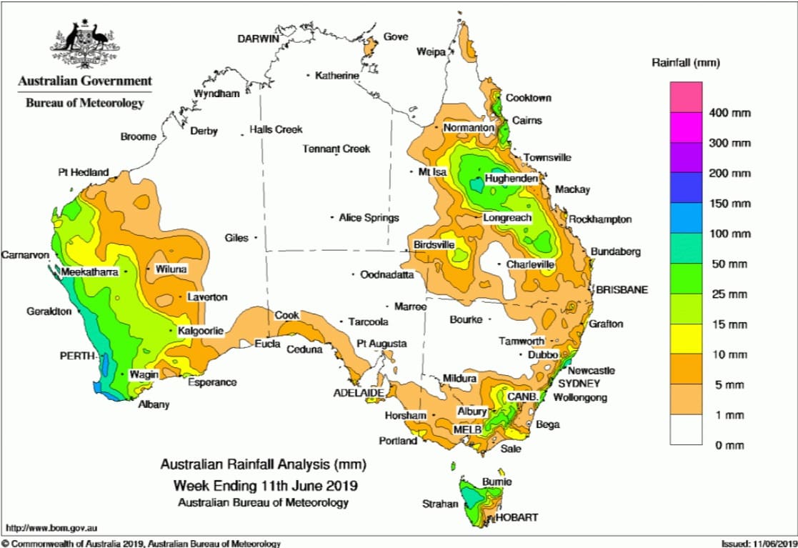
AN upper-level trough produced moderate falls in Queensland’s northern and central interior, while a series of strong cold fronts produced moderate falls in south-west Western Australia.
Past seven days: At the start of the week, a complex low pressure system off the New South Wales coast generated thunderstorms and showers, and brought moderate falls along the central to south-east coast of New South Wales and south into East Gippsland in Victoria. A cold front tracked across Tasmania, with the westerly air stream bringing moderate falls to western parts of that State.
By the middle of the week, an upper-level trough and associated cloud band brought showers and rain across much of central, eastern, and southern Queensland, with isolated heavier falls in the southern tropics and central interior of Queensland. The trough and associated moderate rainfall moved into southern and central eastern Queensland the following day.
In the west, a large rain band associated with a strong cold front tracked over south-west Western Australia and generated widespread moderate falls along the south-west coast of Western Australia, and parts of the western Pilbara, the Gascoyne and Goldfields districts. Another cold front quickly followed, with the vigorous south-westerly flow producing further moderate falls in parts of the western Pilbara and along the south-west coast and adjacent inland districts. Widespread light falls were reported across large parts in the west of Western Australia. The cold front continued to track eastwards, producing mainly light falls in southern South Australia, most of Victoria and Tasmania. Moderate falls were reported in the north-east of Victoria, and in northern and western Tasmania.
At the end of the week, another cold front crossed south-west Western Australia, delivering further moderate falls along the southwest coast of the State.
Rainfall totals in excess of 100 mm were recorded in parts of the central coast of New South Wales and the south-west coast of Western Australia. The highest weekly total was 172 mm at Bickley in Western Australia.
Rainfall totals in excess of 50 mm were recorded along the south-west coast of Western Australia, northwestern and an area of north-eastern Tasmania, parts of the central coast of New South Wales, and areas in the north tropical coast and northern interior of Queensland.
Rainfall totals between 10 mm and 50 mm were recorded in areas of the western Pilbara, Gascoyne, Goldfields and south-west coast, as well as adjacent inland districts of Western Australia; small parts of south-eastern South Australia and in the south-west, north-east and small areas of far eastern Victoria. Similar totals were recorded across most of Tasmania except the south-east; along the east coast of New South Wales; the north tropical coast, northern and central interiors and south-west of Queensland.Little or no rainfall was recorded in remaining parts of Western Australia, the Northern Territory, the far north and west of Queensland, central to western New South Wales, north-western Victoria, and most of South Australia except along the southern coast.
Highest weekly totals
New South Wales and Australian Capital Territory
128 mm Nelson Bay (Nelson Head)
125 mm Bungwahl
92 mm Smiths Lake (Patsys Flat Road)
Victoria
62 mm Falls Creek
41 mm Mount Buller
32 mm Koetong
Queensland
77 mm Tully Sugar Mill
71 mm Babinda Post Office
68 mm Trafalgar Station
Western Australia
172 mm Bickley
154 mm Witchcliffe
153 mm Margaret River
South Australia
17 mm Parndana (Turkey Lane)
15 mm Parndana CFS AWS
13 mm Multiple locations
Tasmania
148 mm Mount Read
75 mm Queenstown (South Queenstown)
65 mm Loongana (Serendipity)
Northern Territory
4 mm Alcan Minesite
3 mm Gove Airport
0.4 mm Groote Eylandt Airport
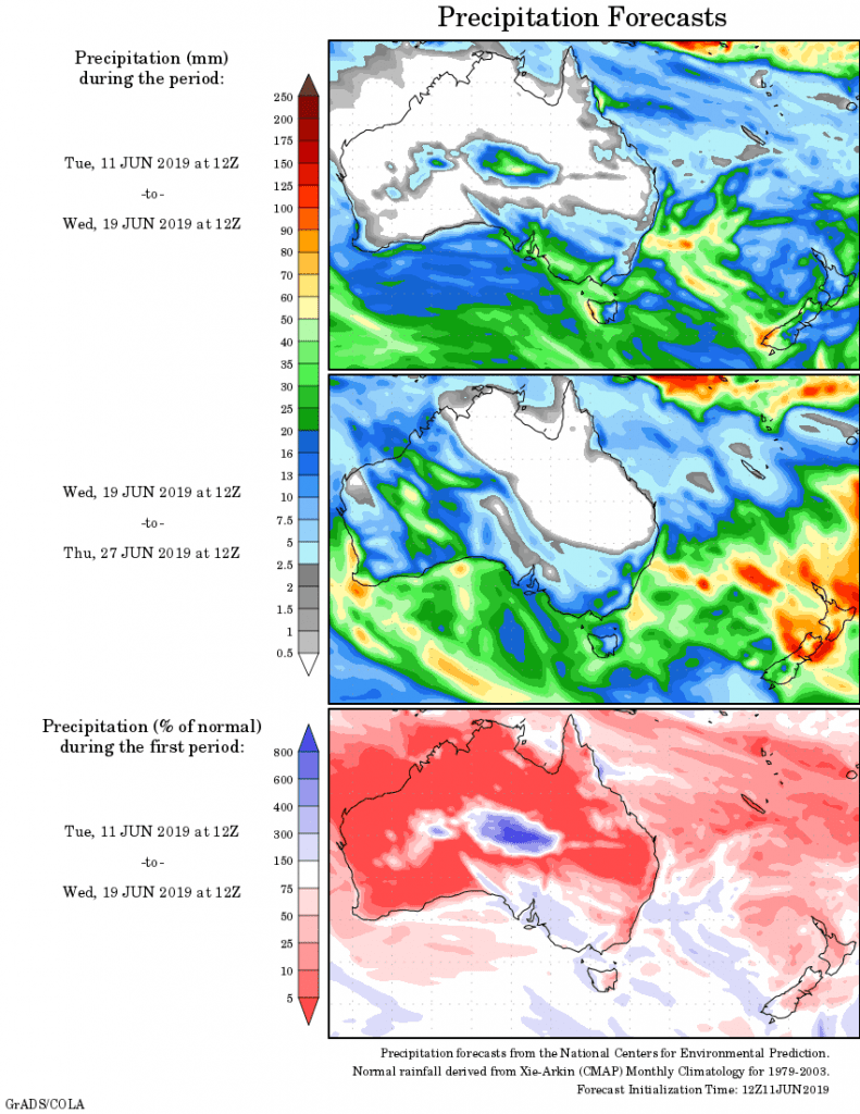
Rainfall outlook:


HAVE YOUR SAY