For today’s 14-day rainfall outlook – scroll to bottom of article
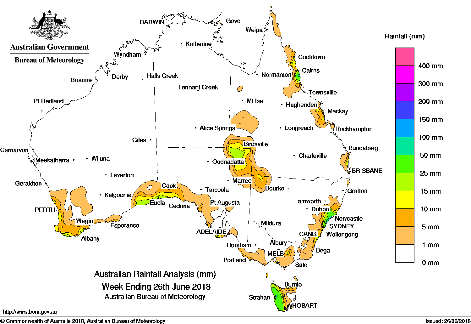
COLD fronts generated light falls along the southern coast of Australia and moderate falls in western Tasmania. A trough produced showers and moderate falls from the central to southeastern coast of New South Wales. The highest weekly total was 105 mm at Careys Peak (Barrington Tops) in New South Wales.
Past seven days: At the start of the week, a surface trough located near the New South Wales coast produced showers and moderate falls from the central to southeast coastal districts of New South Wales. A weak cold front tracked across southern Australia, with mainly light falls recorded along exposed regions of the southwest and southern coasts of Western Australia and South Australia.
Another weak cold front tracked across the Great Australian Bight during the middle of the week. The cold front tracked across southern Victoria before the system directed a cool west to southwesterly airflow across Tasmania, with moderate falls recorded in western Tasmania following the passage of the front.
From the middle of the week, an easterly trough formed to the west of the Great Dividing Range while a firm ridge extended along the Queensland coast, resulting in an onshore, southeasterly flow. Moderate falls were recorded along the north tropical Queensland coast for the remainder of the week. Thunderstorms formed along the surface trough extending over western Queensland at the end of the week, with moderate falls reported in northeastern South Australia and southwestern Queensland.
Rainfall totals in excess of 50 mm were recorded in an area of the central coast of New South Wales, and an area in western Tasmania. The highest weekly total was 105 mm at Careys Peak (Barrington Tops) in New South Wales.
Rainfall totals between 25 mm and 50 mm were recorded in the north tropical Queensland coast, and the central coast district of New South Wales, and in western Tasmania.
Rainfall totals between 10 mm and 25 mm were recorded along the southwest and southern coasts of Western Australia; the southwest coast of South Australia; isolated spots in the northeast, east and south coast of Victoria; and in an area from the central to southeastern coast of New South Wales. Similar totals were also recorded in southwestern Queensland and northeastern South Australia, and along exposed parts of Queensland’s east coast.
Little or no rainfall was recorded in Western Australia, South Australia and Victoria away from their southern coasts; the Northern Territory; most of Queensland except the north tropical coast; eastern Tasmania, and New South Wales excluding the central to southeast coast.
Highest weekly totals
New South Wales and Australian Capital Territory
105 mm Careys Peak (Barrington Tops)
91 mm Norah Head AWS
76 mm Swansea (Catherine St)
Victoria
36 mm Howitt Plains (High Ridge), Mount Wellington
18 mm Cape Schanck
Queensland
67 mm Bingil Bay
66 mm Innisfail
45 mm Greenhaven
Western Australia
33 mm Windy Harbour
26 mm Garden Island
23 mm Margaret River
South Australia
21 mm Neptune Island
16 mm Robe
15 mm Flinders Chase (Rocky River)Parndana (Turkey Lane)
Tasmania
54 mm Zeehan
53 mm Queenstown (South Queenstown)
48 mm Scotts Peak Dam
Northern Territory
2 mm Alcan Minesite
0.2 mm Gove AirportCentre Island
More weekly rainfall totals:
- NSW/ACT totals click here
- Vic totals click here
- Qld totals click here
- WA totals click here
- SA totals click here
- Tas totals click here
- NT totals click here
Source: BOM
Rainfall outlook:
HAVE YOUR SAY