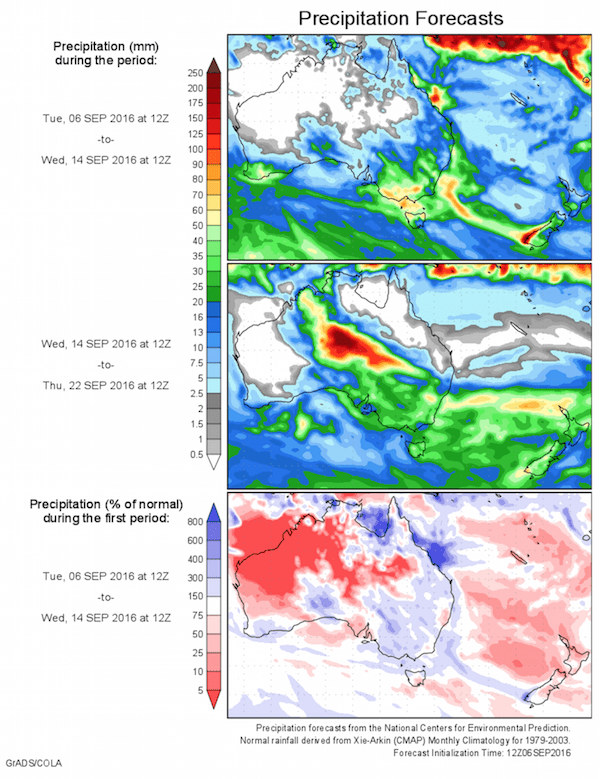
Today’s 14-day rainfall outlook – scroll to bottom of article
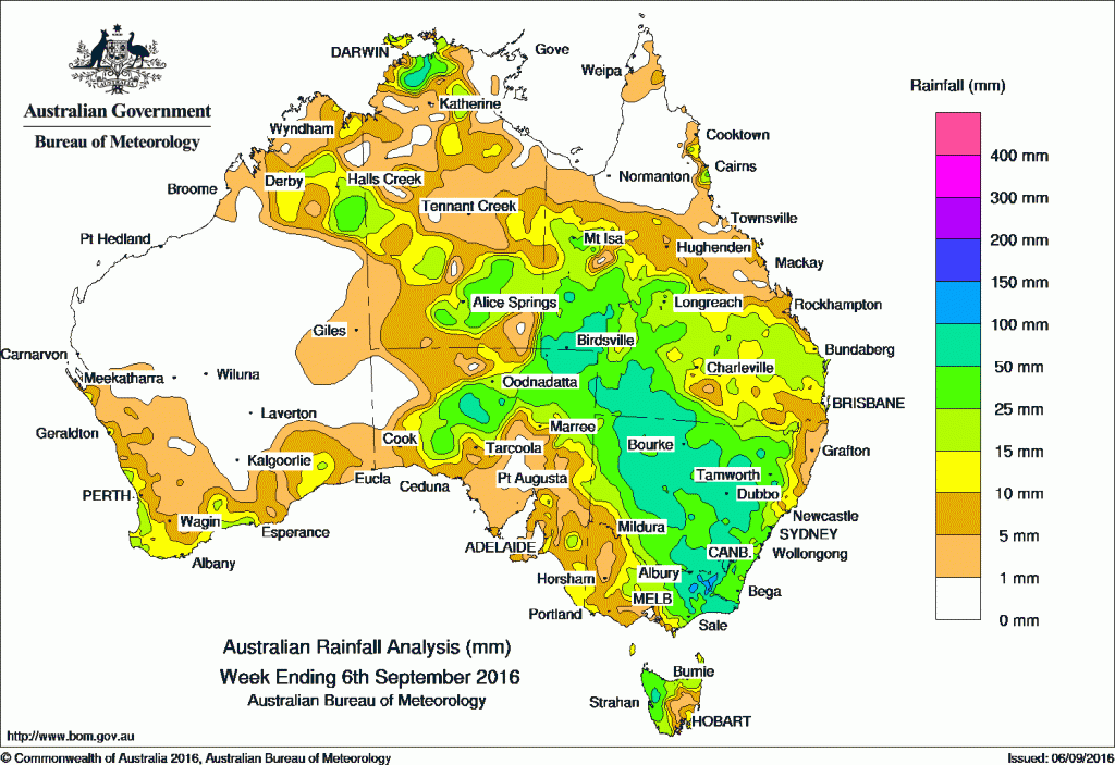
Early Spring rainfall was received in large parts of the country with best falls from the Kimberley and throughout much of the Northern Territory to most of Queensland, New South Wales, Victoria, Tasmania, also central and northeastern parts of South Australia.
Rain over the past week: At the start of the week, a weakening northwest cloudband moved east through the Kimberley, the Northern Territory and into the southeast of the continent. Light to moderate rainfall totals were recorded in western New South Wales, Victoria, Tasmania, southern parts of the Northern Territory and the Kimberley district of Western Australia. A weak cold front and a pre-frontal trough moved over the west and south of Western Australia producing a low to middle level cloudband. Generally light falls were recorded across the South West Land Division, with moderate falls about the Eucla and South East Coastal districts.
Moderate to locally heavy falls were reported in pastoral districts of northern South Australia, southwest Queensland, northwest New South Wales and eastern parts of the Northern Territory during the middle of the week as a trough with multiple low pressure centres tracked across the interior of the continent. The low pressure system deepened over western New South Wales as it tracked southeast across the State.
Moderate rainfall totals were recorded across southern Queensland, most of New South Wales, and eastern Victoria before the system tracked off the east coast of Victoria in the last part of the week. A weak cold front tracked across the southeast of Australia producing light falls in southeast South Australia, southern parts of New South Wales, most of Victoria and parts of western and eastern Tasmania. Isolated thunderstorms formed over the east Kimberley and the Top End at the end of the weak, with isolated heavy rainfall totals in the Darwin–Daly region.
100mm plus: Elevated parts of the Victorian Alps and the Snowy Mountains in New South Wales, and through parts of central New South Wales. The highest weekly total was 155 mm at Thredbo Village in New South Wales.
50mm-100mm: The northwest and northeast pastoral districts of South Australia, East Gippsland and northeastern Victoria, a small area in western Tasmania; also across large parts of central and northwest New South Wales. Similar totals were recorded in far southern and southwest Queensland and in parts of the Top End around the Darwin–Daly region.
10mm- 50mm: The southwest and southern coasts, and in the Kimberley region of Western Australia; throughout northern, central and southern parts of the Northern Territory, across most of the southern half of Queensland and its north tropical coast. Similar totals were recorded in most of New South Wales except the northeast coast and far southwest, central and eastern Victoria, northern and western Tasmania, and in central and southeast areas of South Australia.
Little to no rain: The remaining parts of Western Australia away from the southwest and southern coasts, and away from the Kimberley, parts of western and central southern South Australia, and areas of the Mallee, Wimmera and southwest of Victoria.
Highest totals:
New South Wales and Australian Capital Territory
155 mm Thredbo Village
126 mm Perisher Valley AWS
120 mm Thredbo AWS
Victoria
124 mm Falls Creek (Rocky Valley)
104 mm Hunters Hill
103 mm Falls Creek
Queensland
69 mm Rocky
68 mm Eulo
64 mm Hungerford
Western Australia
36 mm Kununurra Aero
33 mm Marion Downs
32 mm Sturt Creek
South Australia
64 mm Coober Pedy Airport
58 mm Coober Pedy
57 mm Kalamurina
Tasmania
98 mm Mount Read
66 mm Lake Margaret Power Station
56 mm Queenstown (South Queenstown)
Northern Territory
76 mm Ban Ban Springs
65 mm Point Stuart
47 mm Jabiru Airport
More weekly rainfall totals:
- NSW/ACT totals click here
- Vic totals click here
- Qld totals click here
- WA totals click here
- SA totals click here
- Tas totals click here
- NT totals click here
Source: BOM


HAVE YOUR SAY