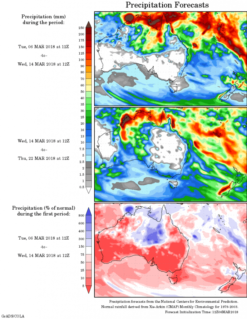
For today’s 14-day rainfall outlook – scroll to bottom of article
Broad low pressure troughs extended across northern Australia, generating thunderstorms and moderate falls.
A deep low pressure system over Queensland’s northwest produced moderate to heavy rainfall in northern Queensland, with record high rainfall at some locations.
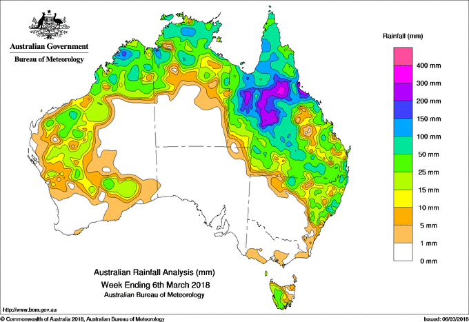
Past seven days: At the beginning of the week, a broad area of low pressure extended across northern Australia, producing thunderstorms and moderate rainfall totals over the Kimberley, Top End, and the north and central coasts of Queensland. A low pressure centre embedded on the surface trough deepened to the west of Townsville, with heavy rainfall accompanying the passage of the low as it drifted slowly west towards the northern interior of Queensland.
A cold front tracked across Tasmania, bringing light to moderate falls in the State’s west at the start of the week. A surface to middle level trough located over the west of the continent produced isolated thunderstorms across Western Australia during the first part of the week, with moderate falls recorded over the eastern Gascoyne and Goldfields districts. Showers also resulted over southeast Western Australia around mid-week.
By the middle of the week, the low over Queensland had deepened and tracked into the State’s northwestern interior. Heavy rainfall continued, generating falls exceeding 100 mm in the northwest, with moderate falls reported across much of western Queensland.
As the low pressure central lingered in the northwest during the remainder of the week, a deep trough extended southwards through central to southern Queensland. The associated cloudband produced rain and storms, resulting in widespread moderate to heavy falls across northwestern, central and southern parts of the State. Moderate falls extended into southeastern Queensland and across much of northeastern New South Wales towards the end of the week. Showers and storms also persisted over the most of Australia’s northern tropics during the latter part of the week.
The highest weekly total was 391 mm at Carsland in northwest Queensland.
Rainfall totals exceeding 200 mm were recorded in the northwest, northern interior and northern tropical coast of Queensland.
Rainfall totals exceeding 100 mm were recorded in across much of Queensland’s north tropical coast, northern interior and Gulf Country, pockets of the Top End of the Northern Territory, and a pocket of the northwestern Kimberley in Western Australia.
Rainfall totals between 50 mm to 100 mm were recorded in the northern Kimberley and pockets of the Pilbara in Western Australia, areas in the north of the Northern Territory, most of northern and central western Queensland, extending down to areas of the State’s southern interior and southeast, and parts of northern and northeastern New South Wales.
Rainfall totals between 10 mm to 50 mm were recorded across the remainder of the Kimberley, the Pilbara, Gascoyne and Goldfields districts of Western Australia, remaining parts of the north of the Northern Territory, remaining parts of Queensland and the northeastern quarter of New South Wales, and western to central Tasmania.
Little or no rainfall was recorded in the southwest and central inland of Western Australia, the southern half of the Northern Territory, South Australia, Victoria, eastern Tasmania, and western, central and southern New South Wales.
Highest weekly totals
New South Wales and Australian Capital Territory
184 mm Careys Peak (Barrington Tops)
146 mm Yarras (Mount Seaview)
137 mm Mullumbimby (Fairview Farm)
Victoria
8 mm Toolangi
6 mm Jindivick
5 mm Multiple locations
Queensland
391 mm Carsland
367 mm Yabulu Qld Nickel
336 mm Rollingstone
Western Australia
117 mm Doongan
108 mm Drysdale River Station
98 mm Yulmbu,
South Australia
1 mm Parawa (Sharon)
0.6 mm Yankalilla, Nangwarry Forestry Sa Depot, Nairne
Tasmania
82 mm Tim Shea (Summit)
59 mm Mount Read
50 mm Longley (River Bend Road)
Northern Territory
226 mm Maningrida Airport
155 mm Kangaroo Flats
151 mm Upper Adelaide River


HAVE YOUR SAY