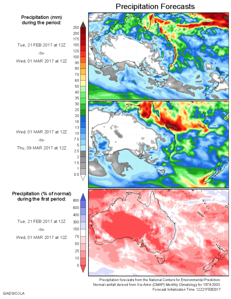
Today’s 14-day rainfall outlook – scroll to bottom of article
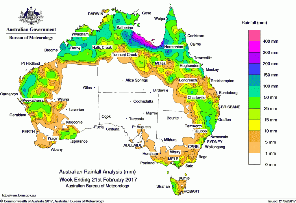
An active monsoon trough produced moderate to heavy falls across northern Australia during the week.
Past seven days: At the start of the week, the monsoon trough extended from a weak tropical low in the Kimberley in Western Australia, across the Northern Territory to another tropical low near the Gulf of Carpentaria. Extensive areas of rain and thunderstorm activity developed over the tropics. A surface trough over the interior of Queensland combined with an upper level disturbance and produced moderate falls in central and northern Queensland.
Another surface trough extended from a low in the northwest through central parts of Western Australia, and produced thunderstorms and showers in the Pilbara, Gascoyne and northern Goldfields districts in Western Australia.
The tropical low in the Gulf of Carpentaria intensified into tropical cyclone Alfred. The tropical cyclone tracked slowly southwards and remained slow-moving, while producing moderate to heavy falls in the Gulf Country. The system weakened in the southern Gulf of Carpentaria between Borroloola and the Queensland–Northern Territory border. The highest weekly total was 921 mm at Sweers Island in the Gulf of Carpentaria.
At the middle to end of the week, a trough extended from central Australia to southeast New South Wales, and moved slowly eastwards. Thunderstorms and showers produced moderate falls in northeastern New South Wales and southeastern Queensland. A cold front and a low pressure system produced light to moderate falls in southeastern South Australia, southern Victoria and western Tasmania.
Rainfall totals between 100 mm and 200 mm were recorded in areas of the western Gascoyne, Pilbara, and Kimberley districts in Western Australia; parts of the central Top End, the Gulf Country and in the north tropical coast of Queensland. Weekly totals in excess of 400 mm were recorded in the south Gulf of Carpentaria as a result of Alfred. The highest weekly total was 921 mm at Sweers Island in Queensland.
Rainfall totals between 50 mm and 100 mm were recorded across much of the Kimberley, and western parts of the Pilbara and Gascoyne in Western Australia; much of the Top End in the Northern Territory; parts of Cape York Peninsula, and pockets of central, southern and eastern Queensland, and northeastern New South Wales. A small part of western Tasmania recorded similar totals.
Rainfall totals between 10 mm and 50 mm were recorded in much of the Gascoyne, Pilbara, Goldfields and Kimberley districts in Western Australia, the northern half of the Northern Territory, northern and eastern Queensland, eastern and northeastern New South Wales, southern Victoria and western Tasmania.
Little or no rainfall was recorded in eastern and southern Western Australia, South Australia, eastern Tasmania, northern and northwestern Victoria, western New South Wales, western Queensland and the southern half of the Northern Territory.
Highest weekly totals
New South Wales and Australian Capital Territory
171 mm Yarras (Mount Seaview)
132 mm Mona Vale Golf Club
105 mm Mooral Creek (The Den)
Victoria
147 mm Willow Grove (Blue Rock Reserv
61 mm Ferny Creek
58 mm Monbulk (Spring Road)
Queensland
921 mm Sweers Island
514 mm Mornington Island Airport
350 mm Burketown Post Office
Western Australia
180 mm Charnley River
179 mm West Roebuck
146 mm Yulmbu
South Australia
17 mm Parawa (Sharon)
11 mm Parawa (Second Valley Forest A
10 mm Mount Gambier Aero
Tasmania
79 mm Mount Read
71 mm Strahan (Andrew Street)
56 mm Strahan Aerodrome
Northern Territory
545 mm Centre Island
392 mm Bing Bong Port
341 mm Borroloola Airport
More weekly rainfall totals:
- NSW/ACT totals click here
- Vic totals click here
- Qld totals click here
- WA totals click here
- SA totals click here
- Tas totals click here
- NT totals click here
Source: BOM


HAVE YOUR SAY