For today’s 14-day rainfall outlook – scroll to bottom of article
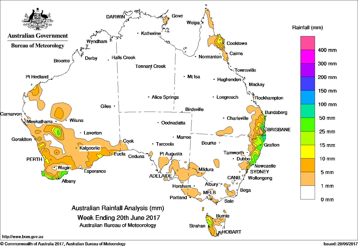
Low pressure troughs and an associated cloudband produced moderate rainfall in coastal areas of Western Australia, while moist onshore flow produced moderate rainfall in coastal areas of Queensland and New South Wales.
Past seven days: At the start of the week, a moist onshore flow in the wake of an eastward moving offshore low produced moderate rainfall in coastal areas of Queensland’s north tropical and southeast, and the far northeast of New South Wales. A trough near the west coast and associated cloudband, combining with a trough from the northwest coast, moved through western and southern Western Australia at the beginning of the week, producing light to moderate rainfall in west Pilbara coastal areas, inland Gascoyne, and the southwestern quadrant of Western Australia.
By mid-week, the cloudband over Western Australia had moved east and dissipated over the southeast of the continent, producing only light rainfall in the southeast South Australia, and northwest and southern Victoria.
During the second half of the week, a trough located off the New South Wales coast and moved slowly eastward, with an associated low pressure system which developed once well offshore. Rainfall was recorded on the north coast of New South Wales and far southeast Queensland, followed by moderate falls on the central coast of New South Wales.
Two weak cold fronts brushed Tasmania during the week producing rainfall over the western parts of the State. A weak cold front approached southwest Western Australia at the end of the week, bringing light to moderate fall in the south coast.
Rainfall totals between 50 mm and 100 mm were recorded in a few locations in the south coast of Western Australia, and small areas in the central and north coast in New South Wales, and southeastern Queensland. Totals exceed 100 mm in isolated spots in the far north coast of New South Wales and the tip of the southeast Queensland. The highest weekly rainfall total of 247 mm was recorded at Point Lookout on Stradbroke Island in Queensland.
Rainfall totals between 10 mm and 50 mm surrounded higher falls along the central and north coast in New South Wales and southeast Queensland, as well as the Cape York’s east coast around Cooktown. The northwest Tasmania, and several areas in Western Australia including the west Pilbara coast, inland Gascoyne, west coast and south coast also recorded between 10 mm and 50 mm rainfall.
Little or no rainfall was recorded in most of the northern half and central Western Australia, most of South Australia, the Northern Territory, most of Queensland away from the southeast and north tropical coast, most of New South Wales away from the central and north coast, most of Victoria, and eastern Tasmania.
Highest weekly totals
New South Wales and Australian Capital Territory
115 mm Ballina Airport Aws
111 mm Green Pigeon (Morning View)
109 mm Careys Peak (Barrington Tops)
Victoria
9 mm Cheltenham Kingston Centre
8 mm Beech Forest
Queensland
247 mm Point Lookout
105 mm Redland (Alexandra Hills)
97 mm Godwin Beach
Western Australia
65 mm Cape Leeuwin
60 mm Walpole
59 mm Walpole Forestry
South Australia
7 mm Nuriootpa Pirsa, Barossa Valley (Duckponds Creek, Tanunda)
Tasmania
55 mm Lake Margaret Power Station
48 mm Mount Read
25 mm Zeehan (West Coast Pioneers Mu
Northern Territory
4 mm Nhulunbuy
1.6 mm Alcan Minesite
0.6 mm Gove Airport
More weekly rainfall totals:
- NSW/ACT totals click here
- Vic totals click here
- Qld totals click here
- WA totals click here
- SA totals click here
- Tas totals click here
- NT totals click here
Source: BOM
HAVE YOUR SAY