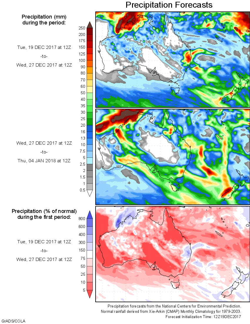
For today’s 14-day rainfall outlook – scroll to bottom of article
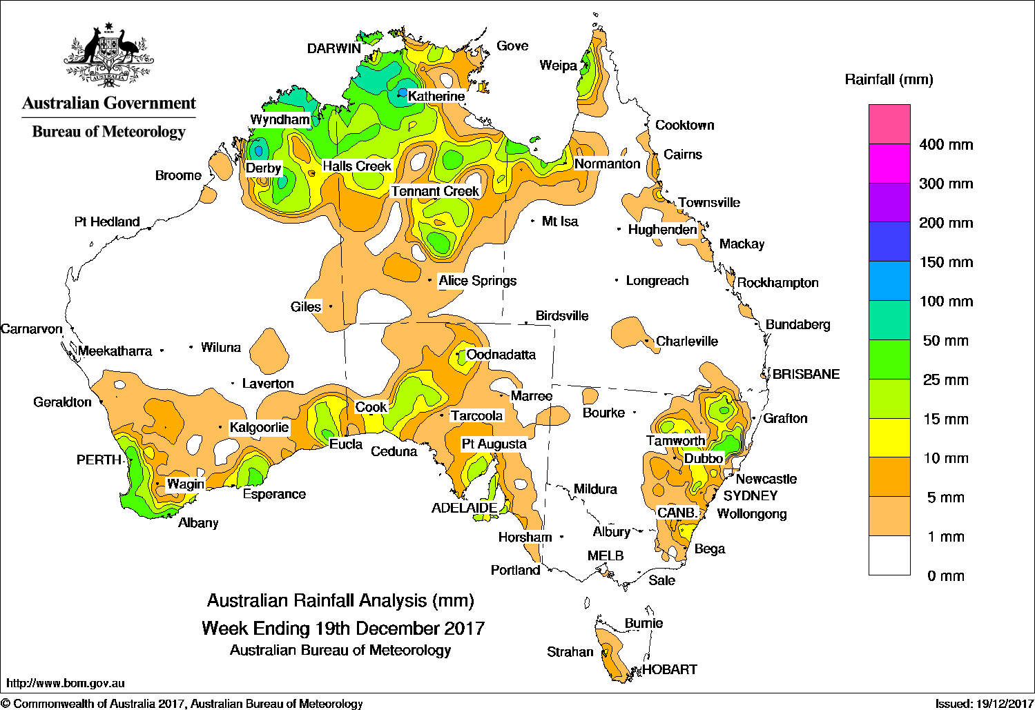
Persistent thunderstorms produced moderate to locally heavy falls for the Kimberley in Western Australia and the northwest Top End in the Northern Territory. A cold front and associated low produced light to moderate falls in the southwest Western Australia.
Past seven days: At the beginning of the week, thunderstorms produced moderate falls in the tropical north about the Gulf Country, the Top End and central parts of the Northern Territory and northern Kimberley. A broad low pressure trough extending from Western Australia to central parts of the Northern Territory and South Australia, ahead of a cold front, moved across eastern parts of the Great Australian Bight, with the embedded thunderstorms producing moderate falls along the southeastern coastline of Western Australia and central parts of South Australia.
During the middle of the week, thunderstorms and showers formed in the vicinity of a surface trough extending across northern Australia. Widespread moderate falls were recorded in the northern Kimberley in Western Australia, throughout most of the Northern Territory and in parts of far northern Queensland. A surface trough extending through inland Queensland and New South Wales also produced thunderstorms with moderate falls recorded in parts of eastern New South Wales and far southern Queensland.
In the latter part of the week, a cold front and associated complex low pressure system tracked across southwest and southern Western Australia. Thunderstorms formed near the low and along the pre-frontal surface trough, and brought moderate falls to the South West Land Division, the southern coasts of Western Australia, and northern and southeastern South Australia. Isolated thunderstorms with moderate falls also reported in the northeast New South Wales.
Rainfall totals in excess of 100 mm were recorded in small parts of the Kimberley in Western Australia, and the northwestern Top End in the Northern Territory, including the highest weekly total of 235 mm at Nitmiluk Rangers in the Darwin–Daly District.
Rainfall totals between 50 mm and 100 mm were recorded in areas surrounding higher falls in the same areas of the northern Kimberley District in Western Australia, and much of the Darwin–Daly District in the Top End in the Northern Territory.
Rainfall totals between 10 mm and 50 mm were recorded in remaining parts of the Kimberley, in the southwest, and along the southern coast of Western Australia; in southwest, southeast and northwest agricultural districts of South Australia; much of the Northern Territory away from the south; far northern Queensland; and parts of eastern New South Wales.
Little or no rainfall was recorded in remaining parts of Western Australia; southern parts of the Northern Territory; northwest and northeast South Australia; most of Tasmania; Victoria; western New South Wales; and most of Queensland except in the far north.
Highest weekly totals
New South Wales and Australian Capital Territory
91 mm Nundle (Head Of The Peel)
80 mm Yarrowitch (Rushbrook)
73 mm Wollomombi (Wollomombi River)
Victoria
2 mm Dellicknora (Tellicura)
1.8 mm Traralgon Creek At Koornalla
1 mm Patyah (Booroopki)
Queensland
56 mm Weipa Aero
48 mm Donors Hill Station
43 mm Weipa Eastern Ave
Western Australia
95 mm Windjana Gorge
88 mm Kalumburu
79 mm Mount Krauss
South Australia
36 mm Parawa (Sharon)
34 mm Parawa
30 mm Curramulka North
Tasmania
11 mm Mount Read
10 mm Lake Margaret Dam
9 mm Strahan (Andrew Street)
Northern Territory
235 mm Nitmiluk Rangers
203 mm Nitmiluk Ridge
127 mm West Waterhouse
More weekly rainfall totals:
- NSW/ACT totals click here
- Vic totals click here
- Qld totals click here
- WA totals click here
- SA totals click here
- Tas totals click here
- NT totals click here
Source: BOM


HAVE YOUR SAY