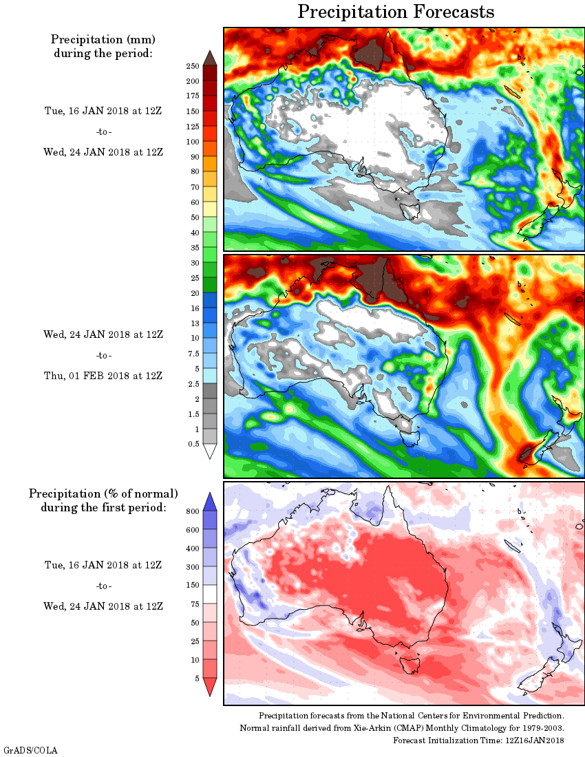
For today’s 14-day rainfall outlook – scroll to bottom of article
Tropical cyclone Joyce made landfall on the north Pilbara coast, producing heavy falls. Thunderstorms and showers produced moderate falls in southeastern Australia.
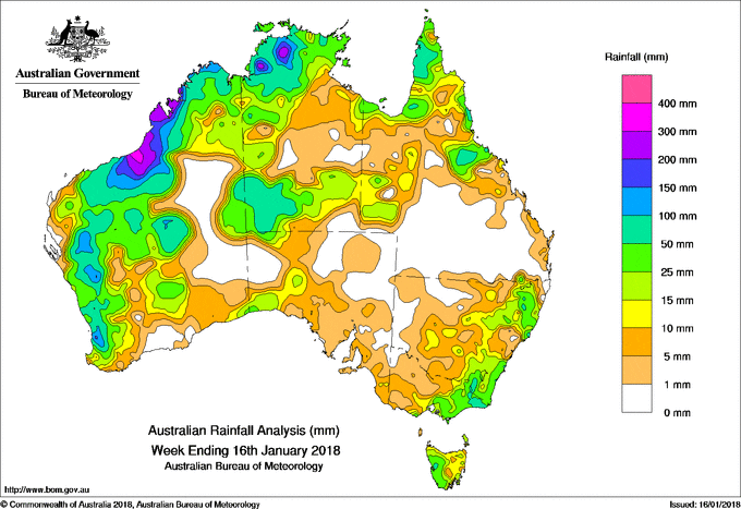
The highest weekly total was 310 mm at Wallal Downs, in the southern Kimberley of Western Australia.
Past seven days: At the start of the week, the monsoon trough over the Australian northwest coast and a developing tropical low near the west Kimberley in Western Australia produced extensive thunderstorms in the Top End of the Northern Territory and the Kimberley coast, with tropical moisture streaming southeast into South Australia. A surface trough and upper level disturbance in southwest Western Australia produced an active cloudband with isolated, embedded showers and thunderstorms. Moderate rainfall totals were recorded over southern Western Australia and western parts of South Australia. In the east, a surface trough moving across southeastern Australia produced thunderstorms with light to moderate fall in eastern New South Wales and Tasmania.
The tropical low developed into a tropical cyclone on 11 January, named tropical cyclone Joyce. The system tracked southwards and made landfall in the far west Kimberley coast near Wallal the next day. Tropical cyclone Joyce soon weakened to a tropical low and moved southwest through the Pilbara and northern Gascoyne. Heavy rainfall with localised very heavy falls was recorded along the system’s passage about the western Kimberley, Pilbara and Gascoyne, with moderate falls recorded across much of northern Australia and central Australia, while a series of surface troughs delivered moderate falls across southern Western Australia and South Australia, also. Widespread light to moderate falls were also recorded in southeastern Australia, including Tasmania during the middle of the week.
From the latter part of the week, ex-tropical cyclone Joyce tracked south parallel to the west coast of Western Australia. The system brought widespread moderate to heavy falls from the northwest to the southwest of Western Australia Heavy rainfall with daily totals in excess of 100 mm around the Perth area saw some January daily rainfall records at the end of the week. An extensive surface trough across the tropical north also produced thunderstorms with moderate rainfall to the northern and central Western Australia, the western Top End in Northern Territory, and the Cape York and tropical north coast of Queensland.
Rainfall totals exceeding 100 mm were recorded in parts of the northwestern Top End in the Northern Territory, and along the Kimberley and Gascoyne coasts and adjacent inland districts; also in areas of the southwest coast of Western Australia. The highest weekly total was 310 mm at Wallal Downs in Western Australia.
Rainfall totals between 50 mm and 100 mm were recorded in areas of northern and eastern Queensland, in areas of eastern New South Wales, far eastern Victoria, and in the southwest and northwest of the Northern Territory. Similar totals were recorded in the Kimberley, Pilbara, parts of the Gascoyne, central interior, and along the southwest coast of Western Australia surrounding heavier falls.
Rainfall totals between 10 mm and 50 mm were recorded in northern, western and southwestern parts of Western Australia, southwest and northwest South Australia, central and eastern Victoria, much of the eastern half of New South Wales. Similar totals were recorded in southern, western and northwestern parts of the Northern Territory, and northwestern and northern Queensland.
Little or no rainfall was recorded in eastern inland parts of Western Australia, northeastern South Australia, northwestern Victoria, western New South Wales, southern Queensland and some eastern parts of the Northern Territory.
Highest weekly totals
New South Wales and Australian Capital Territory
94 mm Thredbo Aws
92 mm Perisher Valley Aws
91 mm Forster – Tuncurry Marine Resc
Victoria
72 mm Cabbage Tree Creek
71 mm Point Hicks (Lighthouse)
67 mm Falls Creek (Rocky Valley)
Queensland
139 mm Cairns Aero
95 mm Mt Sophia
82 mm Charters Towers Airport
Western Australia
310 mm Wallal Downs
302 mm Kimbolton
266 mm Mandora
South Australia
22 mm Nullarbor
16 mm Tarcoola (Mobella), Padthaway South
Tasmania
62 mm Mount Read
49 mm Queenstown (South Queenstown)
42 mm St Helens Aerodrome
Northern Territory
247 mm Wandie Creek
210 mm Mount Bundey South (Defence)
205 mm Fish River
More weekly rainfall totals:
- NSW/ACT totals click here
- Vic totals click here
- Qld totals click here
- WA totals click here
- SA totals click here
- Tas totals click here
- NT totals click here
Source: BOM


HAVE YOUR SAY