For today’s 14-day rainfall outlook – scroll to bottom of article
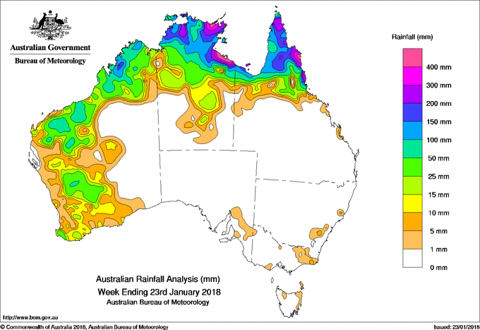
An active monsoon trough produced moderate to heavy rainfall in far northern Australia during the week. Surface and upper level troughs brought moderate falls to the western half of Western Australia.
The highest weekly total was 630 mm at Bing Bong Port in the Top End of the Northern Territory
Past seven days: At the start of the week, a surface trough near coastal Western Australia, which connected to low pressure systems over inland Pilbara and in the southwest, generated showers and thunderstorms in the western parts of the State. Mostly moderate rainfall totals were reported throughout the week in the Pilbara, Gascoyne and Goldfields districts, and the South West Land Division in Western Australia as the surface trough persisted in the west.
During the week, the monsoon trough aligned with the northwest coast of Western Australia, extending across the Top End of the Northern Territory to the Gulf of Carpentaria. Thunderstorms and showers developed near and along the monsoon trough throughout the week, and produced moderate to heavy falls in the Kimberley in Western Australia, the Top End and central parts of the Northern Territory, the Gulf Country and the Cape York Peninsula.
At the end of the week, light falls from isolated showers were recorded in small parts of southeastern Australia as a low pressure trough extended from central to southeast Australia. In the north, a weak tropical low pressure system developed over the Carpentaria District in the Northern Territory, produced locally heavy falls in the western Gulf Country.
Rainfall totals exceeding 100 mm were recorded about the Kimberley coast, across much of the northern Top End of the Northern Territory and Gulf Country, and the Cape York Peninsula in Queensland. Some areas about the north and east coasts reported rainfall totals in excess of 300 mm, including the highest weekly total of 630 mm at Bing Bong Port in the Northern Territory.
Rainfall totals between 50 mm and 100 mm were recorded in the southern tropics of north Queensland; the southern Top End of the Northern Territory; the western Kimberley; and western parts of the Pilbara and Goldfields districts in Western Australia.
Rainfall totals between 10 mm and 50 mm were recorded across remaining areas of the western half of Western Australia, through the central interior of the Northern Territory and areas of northwestern Queensland.
Little or no rainfall was recorded across remaining parts of Australia away from the western half of Western Australia, and away from northern Australia.
Highest weekly totals
New South Wales and Australian Capital Territory
21 mm Mount George (Manning River)
20 mm Faulconbridge (Great Western), Ginninderra (Charnwood)
Victoria
27 mm Snowy River
17 mm Cann River
7 mm Ensay
Queensland
518 mm Hazelmere
422 mm Cooktown Airport
351 mm Daintree Village
Western Australia
130 mm Napier Downs
128 mm Windjana Gorge
126 mm Kalumburu
South Australia
23 mm Crafers (Mt Lofty)
9 mm Mount Mary, Longwood
Tasmania
5 mm Gray (Dalmayne Rd), Swansea (Francis Street)
4 mm Memana (Babel Farm)
Northern Territory
630 mm Bing Bong Port
605 mm Centre Island
500 mm Ngayawili
More weekly rainfall totals:
- NSW/ACT totals click here
- Vic totals click here
- Qld totals click here
- WA totals click here
- SA totals click here
- Tas totals click here
- NT totals click here
Source: BOM


HAVE YOUR SAY