For today’s 14-day rainfall outlook – scroll to bottom of article
Surface troughs and embedded low pressure systems brought moderate falls to southeastern Australia, while an extensive cloudband produced moderate falls through central parts of the Northern Territory, and western, central and southern Queensland.
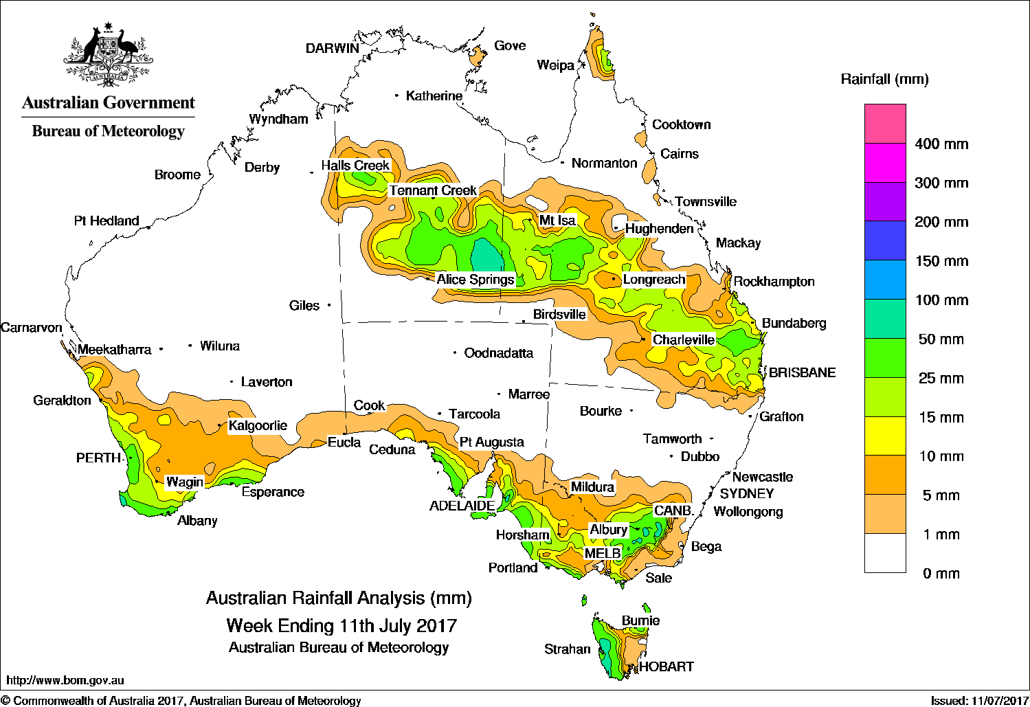
Past seven days: At the start of the week, a surface trough extended from the southern coast of South Australia to Tasmania. Embedded low pressure systems on the surface trough located south of Mount Gambier in South Australia and southwest of Tasmania produced moderate falls in southern South Australia, parts of northwest Victoria, southeastern New South Wales and western Tasmania. Widespread light falls were reported across large areas of Tasmania; also western and central Victoria. A complex area of low pressure developed south of Tasmania, and directed further moderate falls onto the State’s west coast. A surface trough located through inland Queensland produced showers with light to moderate falls recorded in southeast Queensland at the start and end of the week.
In the north, a slow-moving surface trough extended from the Top End in the Northern Territory, then from the northwest to the southeast of Queensland. A sequence of broad upper troughs moved through southern Queensland, which led to bands of showers and patchy rain. Moderate falls were recorded in a band from the northwest, though central districts and into southeastern Queensland in the middle of the week.
In the last part of the week, a surface trough produced a cloudband, with rain and thunderstorms generating moderate falls to the central interior of the Northern Territory. Showers produced moderate falls in the far northern tip of the Cape York Peninsula.
Throughout the week, a series of cold fronts and surface troughs continued to track across southern Australia, resulting in widespread, light falls reported across much of the South West Land Division in Western Australia, southern South Australia, western and central Victoria and southeastern New South Wales.
Rainfall totals in excess of 100 mm were recorded in isolated pockets of western Tasmania, a small areas of the Victorian Alps and the south coast of Western Australia.
Rainfall totals between 50 mm and 100 mm were recorded in southwest Western Australia, southeastern parts of the Northern Territory, in an area of the Snowy Mountains in New South Wales, parts of the Victorian Alps and along the west coast of Tasmania.
Rainfall totals between 10 mm and 50 mm were recorded in southwest and along the southern coast of Western Australia, southern and southeastern South Australia, parts of western, central and northeastern Victoria, southeastern New South Wales and in northern and western Tasmania. Similar totals were recorded through central parts of the Northern Territory, western, central and southeastern Queensland.
Little or no rainfall was recorded in remaining parts of Western Australia, in the north and south of the Northern Territory, much of northern and southwestern Queensland, and most of New South Wales away from the southeast. Similarly, little or no rainfall was recorded in eastern Victoria, southeastern Tasmania, and remaining parts of South Australia away from the southern coast.
Highest weekly totals
New South Wales and Australian Capital Territory
86 mm Cabramurra AWS
52 mm Thredbo Village
48 mm Albury Airport AWS
Victoria
102 mm Mount Buller
75 mm Falls Creek (Rocky Valley)
64 mm Hunters Hill
Queensland
43 mm Proston Post Office
38 mm Leyburn Post Office
35 mm Monogorilby, Ellangowan
Western Australia
106 mm Margaret River
77 mm Witchcliffe
66 mm Jindong
South Australia
89 mm Uraidla
85 mm Aldgate
80 mm Heathfield Works Depot
Tasmania
135 mm Mount Read
99 mm Lake Margaret Power Station
68 mm Zeehan
Northern Territory
53 mm Jervois
38 mm Marqua
36 mm Mount Skinner
More weekly rainfall totals:
- NSW/ACT totals click here
- Vic totals click here
- Qld totals click here
- WA totals click here
- SA totals click here
- Tas totals click here
- NT totals click here
Source: BOM
HAVE YOUR SAY