For today’s 14-day rainfall outlook – scroll to bottom of article
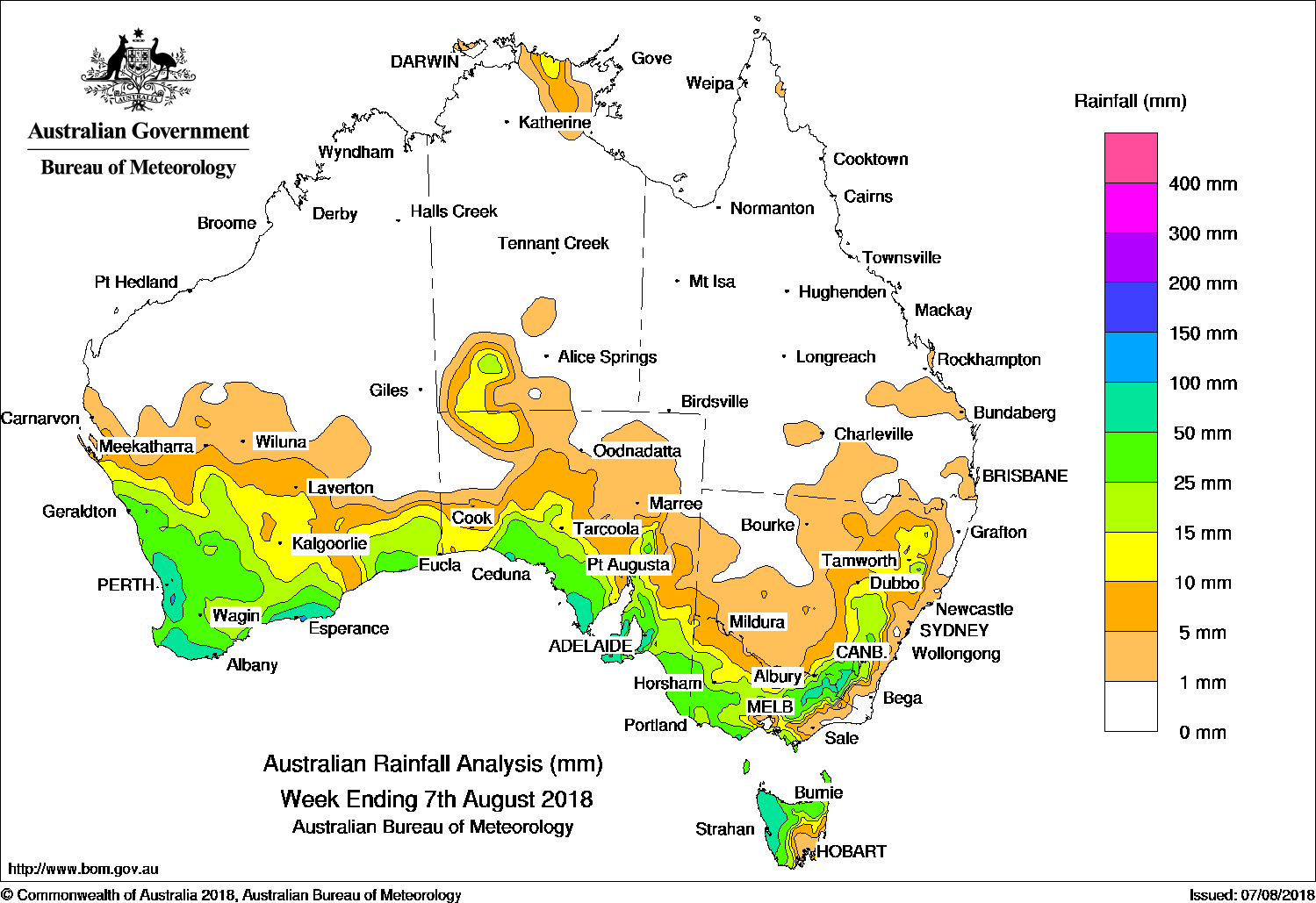
Thunderstorms produced moderate falls in western, central and northeastern Victoria, elevated areas of the Snowy Mountains in New South Wales, and in northwest Tasmania, while another cold front moved north over the South West Land Division, bringing cold southwest to southerly winds in the wake of the front and further moderate falls to the South West Land Division and the southern coast of Western Australia.
Past seven days: At the start of the week, a cold front extending to a low pressure system over Tasmania tracked across far southeast Australia, generating a cloudband and isolated thunderstorms with moderate falls reported in western and northern Tasmania, and widespread light falls across most of Victoria and southeastern South Australia.
In the west, a strong cold front tracked through western and southern Western Australia with a significant cold southwesterly airstream in its wake. Moderate falls were reported along the west and south coasts extending across the South West Land Division and southeast Gascoyne; also in southwest South Australia. The vigorous cold front and the associated pre-frontal trough tracked across South Australia and southern parts of the Northern Territory. Thunderstorms produced moderate falls along the southern coast and agricultural districts of South Australia, and southern parts of the Northern Territory.
By the middle of the week, the strong frontal system continued its track across central New South Wales, Victoria and Tasmania. Thunderstorms produced moderate falls in western, central and northeastern Victoria, elevated areas of the Snowy Mountains in New South Wales, and in northwest Tasmania.
During the last part of the week, another cold front moved north over the South West Land Division, bringing cold southwest to southerly winds in the wake of the front and further moderate falls to the South West Land Division and the southern coast of Western Australia. As this front tracked eastwards, moderate falls were recorded along the southern coast of South Australia, about southern central Victoria and northwestern Tasmania.
The cold front and trough then tracked over New South Wales and the eastern seaboard while a complex low pressure system was located near Tasmania. The associated cloudband with embedded thunderstorms and gusty westerly winds brought moderate falls to parts of southeastern South Australia, southern and northeastern Victoria, and western Tasmania. Moderate falls were also recorded in elevated areas of the Snowy Mountains and in the North West Slopes and Central Tablelands between Inverell and Scone in New South Wales. Light falls were recorded through the parts of eastern New South Wales away from the coast. Thunderstorms developed over the far northern Top End at the end of the week, generating isolated moderate falls.
Rainfall totals in excess of 100 mm were recorded in small areas in the southwest of Western Australia, the Mount Lofty Ranges in South Australia and an area in northwest Tasmania. The highest weekly total was 129 mm at Dwellingup in Western Australia.
Rainfall totals exceeding 50 mm were recorded in coastal parts of the South West Land Division in Western Australia; the Eyre and Yorke Peninsulas as well as Kangaroo Island in South Australia; elevated areas in the Victoria Alps and the Snowy Mountains in New South Wales, and western Tasmania.
Rainfall totals between 10 mm and 50 mm were recorded in remaining areas of the South West Land Division extending into the southern Gascoyne, Goldfields and Eucla districts of Western Australia; an area in the southwest of the Northern Territory; southern South Australia; most of Victoria except the far east and northwest; northern and western Tasmania, and a strip of eastern inland New South Wales.
Little or no rainfall was recorded in remaining parts of Western Australia, most of the Northern Territory, Queensland, much of western, northern and east coast New South Wales; northwestern and eastern Victoria and southeastern Tasmania.
Highest weekly totals
New South Wales and Australian Capital Territory
99 mm Perisher Valley AWS
95 mm Thredbo Village
57 mm Cabramurra AWS
Victoria
89 mm Wilsons Promontory Lighthouse
88 mm Mount Buller
69 mm Lorne (Mount Cowley)
Queensland
10 mm Lady Elliot Island
5 mm Multiple locations
Western Australia
129 mm Dwellingup
127 mm Bickley
120 mm Gidgegannup
South Australia
121 mm Lenswood
116 mm Uraidla
108 mm Uraidla (Sutton Creek)
Tasmania
80 mm Mount Read
77 mm Strahan (Andrew Street)
66 mm Savage River Mine
Northern Territory
14 mm Maningrida Airport
9 mm Uluru Rangers, Watarrka
More weekly rainfall totals:
- NSW/ACT totals click here
- Vic totals click here
- Qld totals click here
- WA totals click here
- SA totals click here
- Tas totals click here
- NT totals click here
Source: BOM
Rainfall outlook:
HAVE YOUR SAY