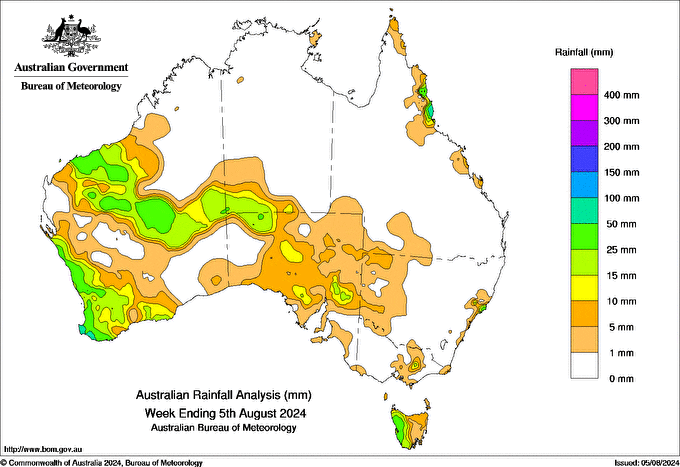
A LOW pressure trough resulted in showers over Western Australia’s South West Land Division, then a strong cold front late on 31 July brought more showers, damaging wind gusts and thunderstorms to the area.
Moist easterly airflow brought showers to Queensland’s North Tropical Coast and eastern Cape York Peninsula.
Unseasonal rain fell in parts of Western Australia’s north and the interior of the mainland late in the week as a trough that developed north-west of Australia brought moisture from the warm Indian Ocean.
A cold front on 3 August resulted in showers for southern South Australia and Tasmania.
Most of Australia recorded little to no rain during the week.
Parts of Western Australia, western Tasmania, the far south-west of the Northern Territory, north-western and pockets of eastern South Australia, and areas of coastal northern Queensland recorded rainfall totals greater than 10 mm during the week. Some of these areas recorded weekly totals between 25 and 50 mm. Weekly totals greater than 50 mm were recorded in the far south-west of Western Australia and coastal areas of Queensland’s north.
The highest weekly total (at a bureau gauge) was 108.6 mm at Tully Sugar Mill in Queensland. The highest daily rainfall during the week (at a Bureau gauge) was 52.6 mm at Jindong, Western Australia, in 24 hours to 9 am on 1 August.


HAVE YOUR SAY