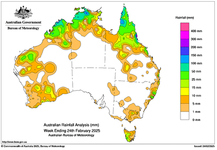
TROPICAL lows, 21U and 22U, brought several days of high rainfall and isolated storms to north-western regions of the Northern Territory’s Top End, northern Western Australia and northern Queensland.
They were declared as Tropical Cyclone Bianca and Tropical Cyclone Alfred respectively on 23 February.
Cold fronts and associated troughs brought scattered showers and storms, some severe, to parts of the southern interior of Western Australia, isolated southern regions of South Australia, Tasmania, central and eastern Victoria and eastern New South Wales.
Weekly rainfall totals of 25-50mm were recorded in parts of northern Australia, isolated regions of the New South Wales and central and southern Queensland coasts.
Weekly rainfall totals of 50-100mm were recorded in parts of northern Queensland, western Tasmania, north-western regions of the Northern Territory and north-western parts of the Kimberley district of Western Australia.
Weekly rainfall totals greater than 100mm were recorded across areas in Queensland including the Cape York Peninsula and the north tropical coast; and in isolated regions of the Northern Territory’s Top End and the West Australian Kimberly district.
The highest weekly total at a Bureau of Meteorology gauge was 339mm at Innisfail Aerodrome in Queensland (six days of available data).
The highest daily total at a bureau gauge was 189.5mm at Paluma Ivy Cottage in Queensland in the 24 hours to 9am on 18 February.
HAVE YOUR SAY