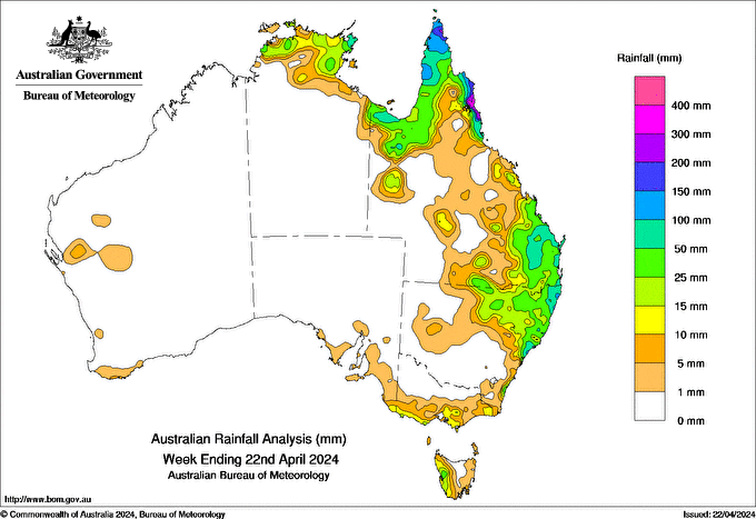
FAR North Queensland and the eastern Top End of the Northern Territory experienced several days of isolated thunderstorms and heavy rainfall, due to easterly flow and a trough with an embedded tropical low extended across Queensland’s northern Peninsula and Gulf of Carpentaria.
Totals for the week exceeded 200 mm along the North Tropical coast, and more than 100 mm in Cape York Peninsula.
Cape Wessel in the Northern Territory, recorded the highest weekly total at 471.4 mm, and the highest daily total of 298.4 mm in the 24 hours to 9 am on 22 April, an April daily record at this station.
Light to moderate rainfall impacted parts of the east coast of New South Wales as an upper level trough extended from central Queensland to northern and eastern parts of New South Wales, with totals generally below 25 mm.
An upper low generated widespread rainfall with local moderate to heavy falls across south-eastern Queensland and north-eastern New South Wales and weekly totals of 15 to100 mm over the area, and many April daily records set in south-east Queensland in the 24 hours to 9 am on 21 April.
A weak cold front brought light showers across Tasmania, south-east South Australia and southern Victoria with weekly rainfall totals generally up to 15 mm.
Away from the north and east, most of Australia recorded no rain.


HAVE YOUR SAY