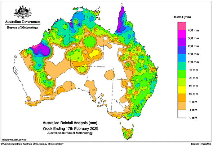
SEVERE Tropical Cyclone Zelia crossed Western Australia’s Pilbara coast as a category 4 system around 12:30pm AWST on 14 February bringing strong winds and heavy rainfall to the Pilbara district.
A monsoon trough and weak tropical low (20U) brought further rainfall to northern Queensland.
A cold front and associated troughs brought scattered showers and storms, some severe, to southern parts of Western Australia, isolated regions of South Australia, Tasmania, eastern New South Wales, and Victoria.
Weekly rainfall totals of 50-100mm were recorded in large parts of northern Australia, regions of south-eastern Queensland, eastern New South Wales and eastern Victoria.
Weekly rainfall totals of 100-200mm were recorded in parts of northern Queensland, isolated northern regions of the Northern Territory, and north-western and pockets of north-eastern Western Australia.
Weekly rainfall totals greater than 200mm were recorded in north-western regions of the Cape York Peninsula, large regions of the Pilbara district and south-western parts of the Kimberley district in Western Australia.
The highest weekly total at a Bureau of Meteorology gauge was 580.4mm at De Grey in the Pilbara district of Western Australia (three days of available data, to 14 February), which included the highest daily total of 261mm in the 24 hours to 9am on 14 February.
HAVE YOUR SAY