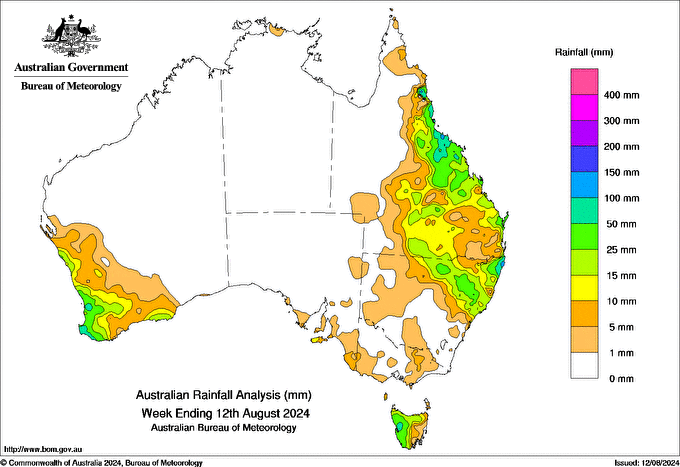
A LOW pressure trough and associated cloud band brought rainfall to north-eastern New South Wales and south-eastern Queensland on 5 August, with daily rainfall totals of 10 to 50 mm in the 24 hours to 9 am on 6 August.
A cold front moved across south-west Western Australia bringing damaging winds and widespread rainfall totals of 15 to 50 mm in the 24 hours to 9 am on 7 August.
At the end of the week, an upper level trough interacting with onshore easterly flow generated widespread showers across coastal areas of Queensland and north-eastern New South Wales, with daily rainfall totals of 15 to 100 mm in the 24 hours to 9 am on 12 August.
Rainfall totals of 25 to 50 mm were recorded across western Tasmania, north-eastern New South Wales, central and northern coastal areas of Queensland, and south-west Western Australia. Elsewhere, there was little to no rain.
Rainfall totals of 50 to 100 mm were recorded in isolated pockets of western Tasmania, the Northern Rivers district of New South Wales, Queensland’s North Tropical Coast and Tablelands district, and south-west Western Australia, with some areas receiving more than 100 mm.
The highest weekly rainfall total (at a Bureau gauge) was 163.2 mm at Rosebank (Repentance Creek), New South Wales.
The highest daily rainfall during the week (at a Bureau gauge) was 157.4 mm at Evans Head RAAF Range AWS, New South Wales, in the 24 hours to 9 am on 12 August.


HAVE YOUR SAY