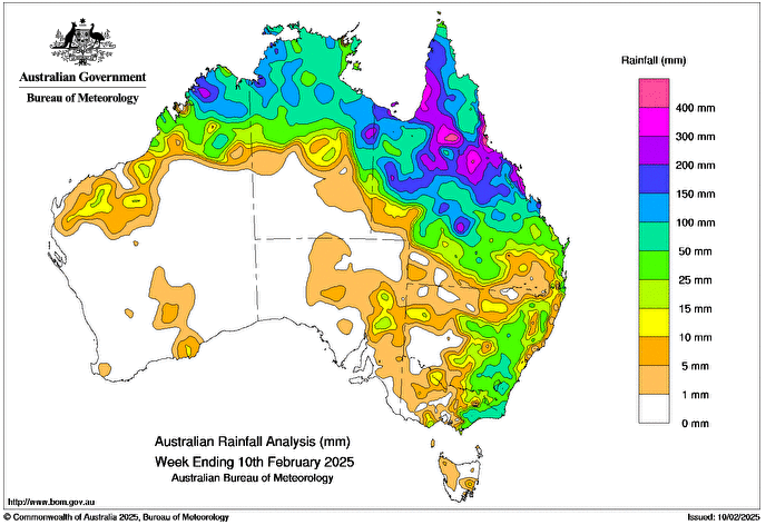
AN active monsoon trough continued to produce heavy widespread rainfall and severe storms over regions of northern Queensland, leading to major flash and riverine flooding.
Cold fronts and associated troughs brought scattered showers and storms, some severe, to southern parts of Western Australia, eastern regions of South Australia and New South Wales, Tasmania, and southern and eastern parts of Victoria.
Weekly rainfall totals of 50-100mm were recorded in large parts of northern Australia, regions of south-eastern New South Wales and eastern Victoria.
Weekly rainfall totals of 100-200mm were recorded in northern and central Queensland, and inisolated northern regions of the Northern Territory and Western Australia.
Weekly rainfall totals greater than 200mm were recorded along Queensland’s east coast between Cairns and St Lawrence, and parts of the Northern Goldfields and Upper Flinders, Gulf Country and North West districts and isolated pockets of the Northern Territory’s Barkly district and the Kimberley district in Western Australia.
The highest weekly total at a Bureau of Meteorology gauge was 769mm at Halifax Alert in Queensland.
The highest daily total at a bureau gauge was 322.2mm at Hamilton Island Airport in Queensland in the 24 hours to 9am on 5 February.
HAVE YOUR SAY