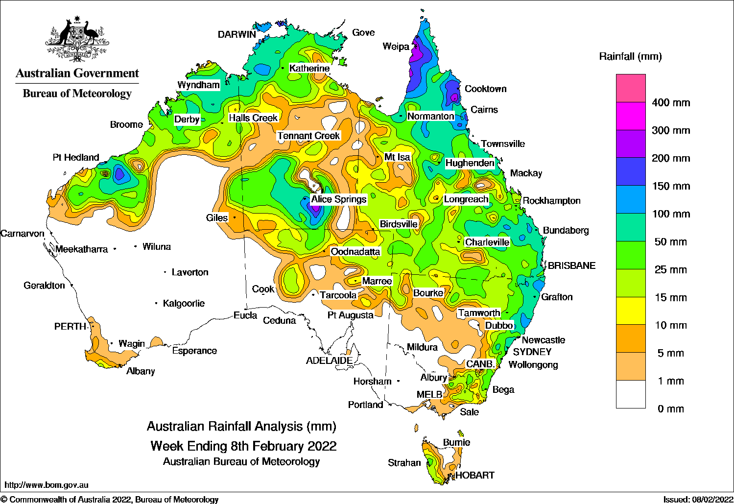
A MONSOONAL trough produced moderate to heavy falls in southern parts of the Northern Territory and northern Queensland, while showers and thunderstorms were recorded in eastern and northern Australia.
Past seven days: At the start of the week, a tropical low pressure system located in the southern Kimberley, and the associated monsoon trough extended across the south of the Northern Territory and inland southern Queensland. A secondary trough extended across northern New South Wales. Moderate rainfall was recorded in the southern half of the Northern Territory. Areas in and around Alice Springs recorded daily falls of 80–120 mm. Thunderstorms and showers developed in northern South Australia, areas of southern, central and northern Queensland, northern and eastern New South Wales and north-east Victoria. Seasonal thunderstorms were reported in the west Kimberley and the Top End in the Northern Territory.
During the first part of the week, the low in the west weakened and moved into waters near the west Kimberley coast. An associated trough moved north and east to the base of theTop End in the Northern Territory and northern Queensland, and connected to a low in the central Tasman Sea. Widespread moderate rainfall was recorded in the Northern Territory, Queensland and north-east New South Wales, with falls contracting to northern and eastern Queensland and coastal New South Wales.
During the second part of of the week, the monsoon trough was mostly located across the Top End in the Northern Territory and the Cape York Peninsula in Queensland. A trough developed inland from the west coast in Western Australia, and connected to a weakening tropical low off the north-west coast. Thunderstorms and showers were recorded in the Pilbara and Kimberley in Western Australia, the Top End in the Northern Territory, and northern Queensland. A cold front moved across the south-west of Western Australia and produced light rainfall in the far south-west, the first falls for over a month.
Rainfall totals in excess of 100 mm were recorded in much of the Cape York Peninsula and the adjacent tablelands and northern Goldfields in Queensland, areas in the southern Northern Territory, areas in the Pilbara and north Kimberley in Western Australia, and small areas on the north and central New South Wales coast. The highest weekly rainfall was 258 mm at Weipa Aero on the west coast of Cape York in Queensland.
Rainfall totals between 50 mm and 100 mm were recorded in the Kimberley and Pilbara districts in Western Australia; most of the northern and western Top End and south of the Northern Territory; the north, central and south-eastern parts of Queensland and coastal north-eastern New South Wales.
Rainfall totals of 10 mm to 50 mm were recorded in northern Western Australia, most of the Northern Territory and Queensland, northern South Australia, northern and eastern New South Wales, north-eastern Victoria and western Tasmania.
Highest weekly totals
New South Wales and Australian Capital Territory
237 mm Bentley (Back Creek)
226 mm Mooral Creek (The Den)
198 mm Careys Peak (Barrington Tops)
Victoria
41 mm Huon (Barkleys Camp)
33 mm Myrtleford (Ovens Research Sta
30 mm Ensay
Queensland
258 mm Weipa Aero
257 mm Southwell Station
253 mm Bingil Bay
Western Australia
162 mm Port Hedland Airport
159 mm Marble Bar
128 mm Kununurra Aero
South Australia
28 mm Gammon Ranges (Moolawatana)
24 mm Todmorden
23 mm TieyonKalamurina
Tasmania
42 mm Mount ReadLake Margaret Dam
37 mm Zeehan (West Coast Pioneers Mu
Northern Territory
194 mm Allambi
174 mm Darwin Hospital
172 mm Leanyer
These rainfall totals are based on real-time rainfall reports, and only limited quality control has been performed on the data. Some station names have been shortened by taking away words such as post office and airport.
HAVE YOUR SAY