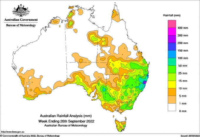
A LOW PRESSURE system developed off the south-eastern Queensland coast on the 22nd of September, with onshore flow bringing locally intense rainfall to coastal areas, mostly over three hours in the evening.
 Weekly totals of 50–100 mm were recorded over the New South Wales northern rivers district and parts of south-eastern Queensland, with higher totals locally in parts of the mid-north coast and the Gold Coast.
Weekly totals of 25–50 mm were recorded for much of inland New South Wales, southern Queensland, the Mallee and Gippsland districts in Victoria, and the Riverland and Murraylands in South Australia.
Weekly totals of 10–25 mm were recorded along the south coast of Western Australia, agricultural districts in South Australia, eastern Tasmania and the far west of Queensland.
The rain across inland New South Wales saw river levels rise along many already flooded rivers, with major flooding recorded along the Narran, Namoi, Macquarie, Lachlan, Narran, Bogan, Gwydir and Culgoa rivers.
The highest weekly total at a Bureau gauge was 392.0 mm at Meldrum (Coolawarrah) (NSW) and the highest daily total was 285.0 mm at Springbrook Road (Qld) in the 24 hours to 9 am on the 23rd.
HAVE YOUR SAY