A COLD front and low pressure system brought widespread rain to the southern half of Australia in the first half of the week.
In the latter part of the week, a pair of cold fronts tracked across south-east Australia, producing damaging to destructive winds and moderate falls over South Australia, Victoria and Tasmania.
At the end of the week, two strong cold fronts moved across south-west Western Australia and produced damaging winds and widespread moderate rainfall.
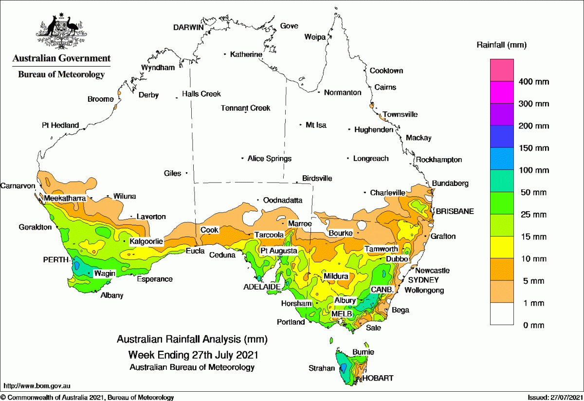
Past seven days: For the week to 27 July 2021, rainfall was recorded in the south-west of Western Australia, southern South Australia, Tasmania, Victoria, New South Wales and south-east Queensland.
At the start of the week, a cold front tracked across south-east Australia and generated moderate falls in southern, north-eastern and eastern Victoria, elevated parts of the Snowy Mountains and Central Tablelands in New South Wales, and western Tasmania. Widespread light falls were recorded across much of central and southern New South Wales and Victoria. In the west, a low pressure system moved over south-west Western Australia, with an associated surface trough extending north-west to the Pilbara coast. Widespread showers and moderate falls were recorded in the southern Gascoyne coast, much of the South West Land Division (SWLD), and adjacent southern Goldfields.
The low moved across the south coast of Western Australia and South Australian coast. Mainly light falls were recorded across southern Western Australia and southern South Australia. As the low tracked across south-east South Australia and into western New South Wales, showers and thunderstorms produced widespread light falls across southern South Australia, northern Victoria, most of New South Wales away from the coast, and north-west Tasmania. The low and the associated surface trough moved eastwards across New South Wales by the middle of the week, and produced moderate falls in south-east Queensland, north-eastern and central New South Wales.
In the last part of the week, a pair of cold fronts tracked across south-east Australia, then Victoria, southern New South Wales, and Tasmania. The passage of the fronts produced damaging to destructive winds, and moderate falls over south-east South Australia, western and north-eastern Victoria, and northern and western Tasmania.
At the end of the week, two strong cold fronts moved across south-west Western Australia and produced damaging winds and widespread moderate rainfall with localised heavier falls to 80 mm in much of the SWLD.
Rainfall totals in excess of 100 mm were recorded in locations along the Perth hills in south-west Western Australia, areas of the Mount Lofty Ranges in South Australia, areas of the Victorian alps and the Snowy Mountains, and western Tasmania. The highest weekly total was 164 mm at Mount Read in western Tasmania.
Rainfall totals in excess of 50 mm were reported in parts of south-west Western Australia, small areas of south-east South Australia, western Tasmania, north-east Victoria and the Snowy Mountains in New South Wales.
Rainfall totals between 10 mm and 50 mm were across the south-west and south of Western Australia, southern South Australia, Tasmania, Victoria, most of New South Wales away from the coast and north-west, and parts of south-east Queensland.
Highest weekly totals list and map
New South Wales and Australian Capital Territory
113 mm Perisher Valley AWS
90 mm Burrinjuck Dam
84 mm Tumut (Simpson Street)
Victoria
120 mm Falls Creek (Rocky Valley)
104 mm Hunters Hill
83 mm Wilsons Promontory Lighthouse
Queensland
27 mm Bell Police
21 mm Macalister
20 mm Springbrook Road
Western Australia
140 mm Mount Solus, Jarrahdale
122 mm Mount William
South Australia
106 mm Uraidla
104 mm Lenswood
94 mm Ashton Piccadilly (Woodhouse)
Tasmania
164 mm Mount Read
135 mm Zeehan (West Coast Pioneers Mu
117 mm Lake Margaret Dam
Northern Territory
0.2 mm Multiple locations
HAVE YOUR SAY